Select units of measurement for the temperature and rainfall tables (metric or imperial).
Average weather, temperature, rainfall, sunshine
The climate of Djibouti is
tropical desert on the coast and at in the lowlands, while it becomes semi-desert in the mountainous areas of the interior.
The
rains are scarce and irregular. There can be periods of drought that last for years, but also rains concentrated in a few days or a few hours, which can cause floods.
The
sea in Djibouti is warm throughout the year, and becomes very warm in summer: the water temperature ranges from 26/27 °C (79/81 °F) in winter to 29/31 °C (84/88 °F) in summer.
Djibouti is a small African country located in the Horn of Africa, halfway between the Equator and the Tropic of Cancer.
The climate in detail
Coast
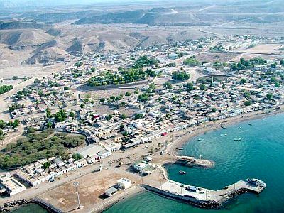
Along the coast, where the capital,
Djibouti City, is located, it's
hot all year round.
In the period that we can call
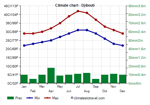
winter, from December to February, the temperature is high, around 29 °C (84 °F) during the day; the sun shines, the rains are rare, and the air is humid, but the sea breeze blows.
Starting from March, the temperature gradually increases, and the heat becomes intense, especially in May, when the daytime temperatures are around 35 °C (95 °F); nights are warm too, and the humidity is still high.
In June, the
summer begins, characterized by intense heat but with lower humidity, especially in June and July, when the wind from the desert, the
Khamsin, often blows, which can also lift dust and sand and therefore reduce visibility.
Summer continues until September with really high temperatures, often exceeding 40 °C (104 °F), while at night, they remain around 30 °C (86 °F). On the coast, the sea breeze can lower the temperature in the afternoon, while increasing moisture. September is perhaps the worst month, since the temperatures remain high, but the atmosphere returns to be quiet and the humidity from the sea makes the
heat oppressive.
In October, the heat continues to be sultry, but the temperatures decrease a bit and become similar to those of May.
In Djibouti City, about 120 millimeters (4.7 inches) of
rain fall per year, a value typical of a desert climate.
However, occasionally there can be heavy rainfall, which can cause flooding, as happened in November 2019, when 155 mm (6.1 in) of rain (more or less, the average value for a whole year) fell in one day. In April 2020, on the other hand, 80 mm (3.1 in) of rain fell in one night, causing a flash flood.
In Djibouti, the sun shines all year round, but especially in spring and autumn.
Interior
In inland areas, where hills and mountains are found, the temperature decreases and rainfall increases with altitude, even exceeding 250 mm (10 in) per year, so much so that the climate becomes
semi-desert.
In fact, these areas, in towns such as Randa, Arta, and Holl-Holl, can receive
some rain from July to September, since they are brushed by the monsoon of the Arabian Sea, as well as some rain in spring, especially in March and April.
Heavy showers can occur from time to time, which can fill the
wadis, the riverbeds that remain dry for most of the year, but can occasionally become streams and overflow, creating landslides and floods, as occurred in November 1994, in April 2004, and in March 2013.
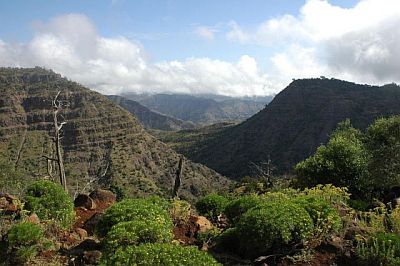
In the south there is even a forest, in the
Day Forest National Park, where there are mountains reaching 1,700 meters (5,600 feet) as well as canyons.
Djibouti's highest mountain is
Moussa Ali, a volcano of 2,201 meters (6,631 feet), located in the north, on the border with Ethiopia and Eritrea.
Ali Sabieh
In
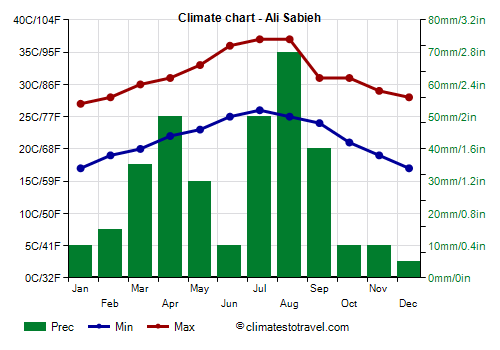
Ali Sabieh, located in the south, at an altitude of 700 meters (2,300 feet), the temperature is a little lower than at sea level, but still remains high.
In Ali Sabieh, rainfall amounts to 335 mm (13 in) per year.
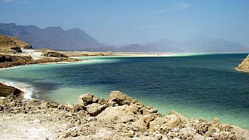
In Djibouti, there is also a
depression, where lake Assal, a salt lake located at 155 meters (510 ft) below sea level, is found. In the west, there is a larger saltwater lake, Lake Abbe.
Tropical cyclones
Every now and then, Djibouti can be affected by tropical cyclones coming from the Arabian Sea, but more rarely and with less intensity than in neighbouring Somalia and Yemen because cyclones tend to weaken when they penetrate inland or enter the Gulf of Aden.
However, the remains of a cyclone can sometimes reach Djibouti, bringing heavy rains that can cause floods, as happened with Tropical Storm 1A in May 1984 and with Cyclone Sagar in May 2018.
Cyclones form from May to December, and are more frequent at the beginning (May-June) and at the end (October-December) of the period.
When to go
The best time to go to Djibouti runs from
December to February, since it's the least hot of the year. November and March are generally acceptable months as well, although a bit hotter. The worst time is the long summer because of the scorching heat.
During the summer, the sea is so warm as to allow long dives along the reef, and swimming is also an effective way to escape the oppressive heat.
What to pack
In
winter: on the coast, bring summer clothes and possibly a light sweatshirt for the evening. When going to the reef, you can bring snorkeling equipment, including water shoes or rubber-soled shoes.
In inland areas, bring light clothes, a sun hat, a desert turban, hiking shoes, sunscreen, and a sweatshirt for the evening. In the mountains, add a sweatshirt and a light jacket for the evening.
It's better for women to avoid shorts and miniskirts.
In
summer: on the coast, bring tropics-friendly, lightweight clothes. When going to the reef, you can bring snorkeling equipment, including water shoes or rubber-soled shoes.
In inland areas, bring lightweight clothes, of natural fabric (cotton or linen), and a desert turban; possibly a light raincoat for the rain showers. In the mountains, add a sweatshirt for the evening.
It's better for women to avoid shorts and miniskirts.
Climate data - Djibouti
| Ali Sabieh (700 meters) |
|---|
|
| Jan | Feb | Mar | Apr | May | Jun | Jul | Aug | Sep | Oct | Nov | Dec |
|---|
| Min temp. | 17 | 19 | 20 | 22 | 23 | 25 | 26 | 25 | 24 | 21 | 19 | 17 |
|---|
| Max temp. | 27 | 28 | 30 | 31 | 33 | 36 | 37 | 37 | 31 | 31 | 29 | 28 |
|---|
| Precip. | 10 | 15 | 35 | 50 | 30 | 10 | 50 | 70 | 40 | 10 | 10 | 5 |
|---|
| Prec. days | 1 | 2 | 2 | 3 | 4 | 4 | 3 | 4 | 4 | 2 | 1 | 1 |
|---|
|
|
|
|
| Djibouti |
|---|
|
| Jan | Feb | Mar | Apr | May | Jun | Jul | Aug | Sep | Oct | Nov | Dec |
|---|
| Min temp. | 22 | 23 | 24 | 25 | 27 | 29 | 31 | 31 | 29 | 26 | 23 | 22 |
|---|
| Max temp. | 29 | 29 | 30 | 32 | 35 | 39 | 42 | 41 | 37 | 33 | 31 | 29 |
|---|
| Precip. | 10 | 5 | 10 | 20 | 10 | 10 | 10 | 10 | 5 | 10 | 10 | 10 |
|---|
| Prec. days | 0 | 0 | 1 | 2 | 3 | 3 | 3 | 4 | 3 | 1 | 1 | 1 |
|---|
|
|
| Sun hours | 8 | 8 | 9 | 9 | 10 | 9 | 8 | 9 | 9 | 10 | 10 | 9 |
|---|
| Sea temp | 26 | 26 | 27 | 28 | 30 | 31 | 30 | 29 | 31 | 30 | 28 | 27 |
|---|