Select units of measurement for the temperature and rainfall tables (metric or imperial).
Average weather, temperature, rainfall, sunshine
The climate of Eritrea is
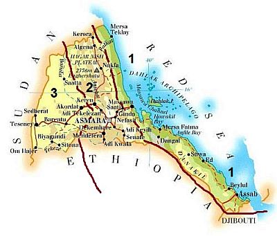
tropical desert on the coast and the eastern plain (zone 1 on the map),
mild semiarid in the mountainous belt (zone 2 on the map), and
tropical semiarid in the south-west (zone 3).
From June to September, the country is influenced by the
southwest monsoon coming from Ethiopia, which brings a bit of rain, especially in the central and southern inland part.
The
sea in Eritrea is warm all year round, with a temperature of 25 °C (77 °F) even in January. In summer, with a temperature of 31/32 °C (88/90 °F) from June to October, the Red Sea becomes one of the warmest seas in the world.

The climate in detail
The coast
Along the coast of the
Red Sea, (zone 1 on the map), the climate is desert and hot all year round.
Massawa

In
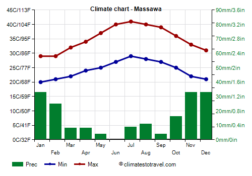
Massawa, winter, from December to March, is hot and sunny: daytime temperatures are around 30 °C (86 °F). Summer, from May to September, is oppressive, with daytime temperatures about 40 °C (104 °F), but with peaks of 45 °C (113 °F), and the humidity of the sea that aggravates the feeling of heat.
From October to April, there can be some rain, usually not abundant, but the sun frequently shines. In summer, some cloud banks can affect this area, and rare rains occur as part of the southwest monsoon. On average, only 180 millimeters (7 inches) of rain fall per year.
On the coast, the sun shines all year round, yet, as mentioned, some cloud banks can pass even in summer.
In the southern part of coast, in
Assab (or Aseb), the climate is similar, but it's even more arid: in an average year, just 60 mm (2.4 in) of rain fall.
In the
Dahlak Archipelago, the summer temperatures are a bit lower than on the coast, but the higher humidity makes the heat unbearable.
In the central inland area, we find the
Danakil Depression, where there are salt lakes and salt mines; here, the weather is scorchingly hot all year round, with temperatures around 40 °C (104 °F) for most of the year, and a little lower in winter.
The mountains
In the
mountainous belt that crosses the central part of Eritrea from north to south (zone 2 on the map), the climate is mild because of the altitude, and it's also moderately rainy, at least in the center-south, while the northern part is desert. The highest peak, Emba Soira, reaches 3,000 meters (9,800 ft) of altitude and is located in the south.
Asmara

In the capital,
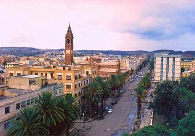
Asmara (or Asmera), the climate is pleasant because it is located at 2,300 meters (7,500 ft) above sea level.
Daytime temperatures are around 22/23 °C (72/73 °F) in winter, they are a little higher from March to June, and then they drop a bit in July and August, which are the only really rainy months. Night temperatures are cool in summer and very cool or even cold in winter.
Throughout the year, about 500 mm (20 in) of rain fall; the rains are almost entirely absent from October to March, a few short showers occur from April to June and again in September, and as mentioned, there are two rainy months, July and August.
The amount of sunshine is great from October to February, good in spring, and low in July and August, when the sky is often cloudy. All in all, the climate in Asmara is good from October to May, and the best months are probably October and November.

Some mountainous areas located north-east of Asmara receive more rain and are therefore greener; in fact, there are even some forests.
The west
In the
western part of Eritrea (zone 3 on the map), the climate is desert in the north and semi-desert or semi-arid in the south, where a bit of rain due to the summer monsoon falls from June to September.
Agordat

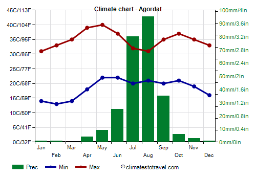
In Agordat (or Ak'ordat), located in the south-central part, at 600 meters (2,000 feet) above sea level, 260 mm (10.2 in) of rain fall per year, concentrated from June to September.
The temperature is high in winter, with more than 30 °C (86 °F) even in January, but nights are quite cool. The temperature becomes
scorching in spring, reaching 39/40 °C (102/104 °F) in April and May, while it decreases with the arrival of the monsoon, but at the cost of an increase in humidity. Between mid-September and November, hot weather returns, although a little less intense than in spring, with highs about 35/37 °C (95/99 °F).
In Agordat, the sun shines regularly in the long dry season, while in summer, the sunshine hours decrease here as well, though less than in Asmara.
In the south-west, the landscape is still arid, but the summer rains are more abundant, so much so that precipitation exceeds 600 mm (23.5 in) per year, allowing for the survival of a greater amount of shrubs and trees.
Tropical cyclones
Every now and then, the extreme south of Eritrea (see Assab) can be affected by a tropical cyclone coming from the Arabian Sea, but more rarely and with less intensity than in Somalia and Yemen because cyclones tend to weaken when they enter the Gulf of Aden.
However, the remains of a cyclone can sometimes arrive here, bringing heavy rains, as happened with Tropical Storm 1A in May 1984 and with Cyclone Sagar in May 2018.
Cyclones form from May to December, and are more frequent at the beginning (May-June) and at the end (October-December) of the period.
When to go
The best time to visit Eritrea runs
from December to February, since it is the least hot and the driest of the year. It must be said that it is still a scorching period in some regions, especially in the Danakil, but also in the entire western part at low altitudes, where, however, the heat is more bearable and nights are cool, especially in December and January (in February, the temperature already starts to increase a little).
What to pack
In
winter. In Massawa, on the Dahlak Islands and the northern coast: bring light clothing, a light sweatshirt for the evening, and possibly a light raincoat or umbrella. When going to the reef, you can bring snorkeling equipment, including water shoes or rubber-soled shoes. In Danakil, loose-fitting, light-colored clothing, light and long shirts and pants of natural fibers (cotton, linen), a desert turban, hiking shoes. In Asmara and the highlands, spring/autumn clothes, a jacket and a sweater for the evening, a sun hat, and sunscreen. In the western inland areas, light clothes, a desert turban, and a sweatshirt and a light jacket for the evening.
In
summer. On the coast, bring tropics-friendly, lightweight clothes. When going to the reef, you can bring snorkeling equipment, including water shoes or rubber-soled shoes. In Danakil, bring loose-fitting, light-colored clothing, light and long shirts and pants of natural fibers (cotton, linen), a desert turban, and hiking shoes. In Asmara and the highlands, spring/autumn clothes, a light jacket and a sweater for the evening, and a raincoat or umbrella. For the western inland areas, light clothes, and a light raincoat.
Climate data - Eritrea
| Agordat (600 meters) |
|---|
|
| Jan | Feb | Mar | Apr | May | Jun | Jul | Aug | Sep | Oct | Nov | Dec |
|---|
| Min temp. | 14 | 13 | 14 | 18 | 22 | 22 | 20 | 21 | 20 | 21 | 19 | 16 |
|---|
| Max temp. | 31 | 33 | 35 | 39 | 40 | 37 | 32 | 31 | 35 | 37 | 35 | 33 |
|---|
| Precip. | 0 | 0 | 0 | 5 | 10 | 25 | 80 | 95 | 35 | 5 | 5 | 0 |
|---|
| Prec. days | 1 | 1 | 1 | 1 | 3 | 4 | 6 | 7 | 4 | 2 | 1 | 1 |
|---|
|
|
| Sun hours | 9 | 10 | 10 | 10 | 10 | 9 | 7 | 8 | 9 | 10 | 10 | 9 |
|---|
|
| Asmara (2,300 meters) |
|---|
|
| Jan | Feb | Mar | Apr | May | Jun | Jul | Aug | Sep | Oct | Nov | Dec |
|---|
| Min temp. | 6 | 7 | 9 | 10 | 11 | 11 | 11 | 11 | 9 | 9 | 8 | 6 |
|---|
| Max temp. | 23 | 24 | 25 | 25 | 25 | 25 | 22 | 22 | 23 | 22 | 22 | 22 |
|---|
| Precip. | 5 | 5 | 15 | 30 | 40 | 40 | 175 | 150 | 25 | 15 | 20 | 5 |
|---|
| Prec. days | 2 | 2 | 3 | 5 | 7 | 6 | 7 | 8 | 5 | 3 | 3 | 3 |
|---|
|
|
| Sun hours | 10 | 10 | 9 | 8 | 8 | 6 | 4 | 4 | 6 | 10 | 10 | 10 |
|---|
|
| Assab |
|---|
|
| Jan | Feb | Mar | Apr | May | Jun | Jul | Aug | Sep | Oct | Nov | Dec |
|---|
| Min temp. | 21 | 22 | 23 | 25 | 27 | 28 | 30 | 30 | 28 | 26 | 24 | 22 |
|---|
| Max temp. | 31 | 32 | 34 | 36 | 37 | 38 | 41 | 41 | 38 | 36 | 34 | 32 |
|---|
| Precip. | 5 | 5 | 0 | 5 | 0 | 0 | 5 | 5 | 0 | 0 | 5 | 5 |
|---|
| Prec. days | 1 | 1 | 0 | 0 | 0 | 0 | 1 | 0 | 0 | 0 | 0 | 0 |
|---|
|
|
| Sun hours | 9 | 9 | 9 | 9 | 10 | 9 | 8 | 8 | 9 | 10 | 9 | 9 |
|---|
| Sea temp | 26 | 26 | 26 | 28 | 30 | 31 | 31 | 31 | 32 | 31 | 28 | 26 |
|---|
| Keren (1,600 meters) |
|---|
|
| Jan | Feb | Mar | Apr | May | Jun | Jul | Aug | Sep | Oct | Nov | Dec |
|---|
| Min temp. | 13 | 14 | 15 | 16 | 18 | 19 | 17 | 17 | 16 | 14 | 14 | 13 |
|---|
| Max temp. | 26 | 27 | 29 | 30 | 32 | 30 | 26 | 24 | 27 | 28 | 27 | 25 |
|---|
| Precip. | 5 | 5 | 5 | 15 | 25 | 30 | 110 | 110 | 30 | 10 | 10 | 5 |
|---|
| Prec. days | 2 | 2 | 2 | 3 | 4 | 5 | 6 | 7 | 4 | 3 | 2 | 2 |
|---|
|
|
|
|
| Keren |
|---|
|
| Jan | Feb | Mar | Apr | May | Jun | Jul | Aug | Sep | Oct | Nov | Dec |
|---|
| Min temp. | 21 | 21 | 23 | 25 | 26 | 28 | 29 | 29 | 27 | 25 | 23 | 21 |
|---|
| Max temp. | 31 | 32 | 34 | 36 | 37 | 39 | 39 | 39 | 37 | 36 | 34 | 32 |
|---|
| Precip. | 10 | 10 | 10 | 10 | 5 | 0 | 15 | 15 | 5 | 5 | 10 | 15 |
|---|
| Prec. days | 1 | 1 | 1 | 0 | 1 | 1 | 2 | 3 | 2 | 1 | 0 | 1 |
|---|
|
|
|
| Sea temp | 26 | 26 | 26 | 28 | 30 | 31 | 31 | 32 | 32 | 31 | 28 | 26 |
|---|
| Massawa |
|---|
|
| Jan | Feb | Mar | Apr | May | Jun | Jul | Aug | Sep | Oct | Nov | Dec |
|---|
| Min temp. | 19 | 19 | 20 | 22 | 24 | 26 | 28 | 28 | 26 | 23 | 21 | 20 |
|---|
| Max temp. | 29 | 29 | 32 | 34 | 37 | 40 | 41 | 40 | 39 | 36 | 33 | 30 |
|---|
| Precip. | 35 | 25 | 10 | 10 | 5 | 0 | 10 | 10 | 5 | 15 | 35 | 35 |
|---|
| Prec. days | 3 | 2 | 2 | 1 | 1 | 0 | 0 | 0 | 0 | 2 | 1 | 3 |
|---|
|
|
| Sun hours | 8 | 7 | 8 | 9 | 10 | 9 | 8 | 9 | 9 | 9 | 10 | 8 |
|---|
| Sea temp | 26 | 26 | 27 | 28 | 30 | 31 | 32 | 32 | 32 | 31 | 29 | 27 |
|---|
| Teseney (590 meters) |
|---|
|
| Jan | Feb | Mar | Apr | May | Jun | Jul | Aug | Sep | Oct | Nov | Dec |
|---|
| Min temp. | 16 | 17 | 19 | 22 | 25 | 24 | 23 | 22 | 22 | 23 | 20 | 17 |
|---|
| Max temp. | 33 | 35 | 38 | 40 | 40 | 39 | 35 | 34 | 36 | 37 | 36 | 34 |
|---|
| Precip. | 0 | 0 | 0 | 5 | 15 | 40 | 110 | 110 | 50 | 10 | 0 | 0 |
|---|
| Prec. days | 0 | 0 | 0 | 1 | 3 | 5 | 8 | 9 | 5 | 2 | 0 | 0 |
|---|
|
|
|
|
See also the
temperatures month by month