Select units of measurement for the temperature and rainfall tables (metric or imperial).
Average weather, temperature, rainfall, sunshine
In the Republic of Congo, an African country crossed by the Equator, the climate is
equatorial (hot and humid all year round, with no real dry season) in the north, and
tropical (hot and humid, with a dry and cooler season in winter) in the center and south.
In the north, the
temperatures are high throughout the year, and the air is muggy, even though the altitude of a few hundred meters makes it a little more bearable than if it was at sea level. In the center-south, the temperature decreases from June to September, especially along the coast, where it becomes a bit cool during the day, and on the hills of the Plateaux Department, when it becomes a bit cool at night.
The amount of
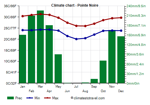
rainfall ranges from 1,500 to 2,000 millimeters (60 to 79 inches) per year in the north, while in the south it drops below 1,500 mm (60 in), and reaches a low of 1,200 mm (47 in) on the coast. In the center and south, the dry season, which corresponds to the winter of the southern hemisphere, runs from June to August in the center, from June to September in the south (see Brazzaville), and from mid-May to mid-October on the coast (see Pointe-Noire).
The amount of
sunshine is not excellent throughout Congo, and it does not get better in the austral winter, even in the center-south where it is the dry season. On the other hand, in the period from October to April, between one rain shower and another, the sun comes out.
The climate in detail
The north
In the
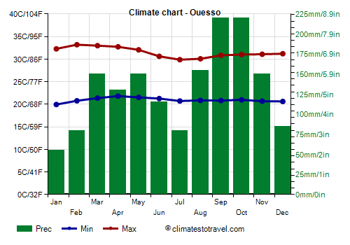
north (see Ouésso,
Impfondo), temperatures are stable during the year, however, they slightly decrease in July and August, even though we are north of the equator.
Ouésso

In
Ouésso, located in the north, at 350 meters (1,150 ft) of altitude, highs reach 33 °C (91.5 °F) in February and March, while they drop to 30 °C (86 °F) in July and August.
Although, as mentioned, there is no real dry season in the north, there are
two rainier periods due to the zenith passages of the sun (that is, when it shines directly overhead in the sky at mid-day) and two relatively dry periods, that is, December to February and June to August. In addition, the more you go to the north, the more evident is the first dry period (the one that goes from December to February) because we are moving away from the equator and entering the area where the rainfall regime is typical of the Northern Hemisphere (ie with a dry winter).
The result is that the rainfall in the north is better distributed, so the area is covered by
forest, while the central and southern areas are covered by savanna.
In the north, the sun does not shine very often. However, it can be seen a little more often in the hotter period, from January to May, and less often in the cooler period, in July and August.
Center-south
As mentioned, in the center-south, which is located south of the equator, and especially on the coast, the temperature decreases from June to September. This happens because of a cool sea current that arrives in winter, the
Benguela Current.
Pointe-Noire

In
Pointe-Noire, located on the coast, daytime temperatures drop to 26 °C (79 °F) in July and August.
On the coast, there is a clear dry season due to the aforementioned Benguela Current, which almost completely inhibits rain cloud formation.
On the coast, the sun does not shine often even in the dry season, since the current generates fogs and low clouds, which reduce sunshine.
The
sea is warm enough for swimming from October to May, while it gets a little cool, but remains after all acceptable, in July and August, when it drops to 22 °C (72 °F).
Brazzaville

In the capital,
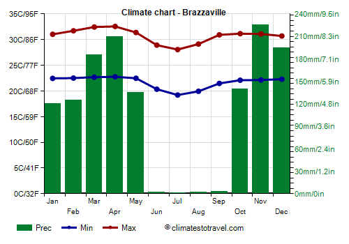
Brazzaville, which is situated at 320 meters (1,050 feet) above sea level, in the south-east, along the Congo River, which gives its name to the country, daytime temperatures are about 31 °C (88 °F) from September to January, they go up to 32/33 °C (90/91 °F) from February to April, and then they drop to around 28/29 °C (82/84 °F) from June to August. At night, it can be cool from June to August, while during the day it can be very hot for most of the year, but especially from mid-August to October, i.e. at the end of the dry season and before the rains begin.
In Brazzaville too, the sun does not shine very often, also, there is no big difference between the different periods of the year.
In Brazzaville, rainfall amounts to 1,500 mm (59 in) per year, with two maxima in March-April and November-December, while it practically never rains from June to August.
North of Brazzaville, on the Koukouya Plateau, it rains more than in the capital, around 1,800/2,000 mm (70/80 in) per year, with two maxima in March-April and October-November.

When to go
The best time to visit the Republic of Congo runs from
June to August, since it is the coolest and the driest, except in the north, where it rains even during this period. However, even though it's not too hot, moisture is high and the sky is cloudy even in the center and south, where it's the dry season. Remember that nights can be cool on the plateau, and on the coast the weather can get a little cool as well, at least for a beach holiday, also because of the lack of sunshine.
In August, at the end of the dry season, the animals of the savanna gather in the few remaining waterholes or along the rivers, so they are easier to spot.
What to pack
All year round, bring light clothes of natural fibers, a light sweatshirt for the evening, an umbrella or a light raincoat for showers during the rainy season. From June to September, you can add a sweatshirt or sweater and a light jacket, especially in the south and along the coast.
Climate data - Congo
| Brazzaville (320 meters) |
|---|
|
| Jan | Feb | Mar | Apr | May | Jun | Jul | Aug | Sep | Oct | Nov | Dec |
|---|
| Min temp. | 23 | 22 | 23 | 23 | 23 | 21 | 20 | 20 | 22 | 22 | 22 | 22 |
|---|
| Max temp. | 31 | 32 | 32 | 33 | 31 | 29 | 28 | 29 | 31 | 31 | 31 | 31 |
|---|
| Precip. | 160 | 135 | 190 | 170 | 130 | 10 | 5 | 10 | 45 | 165 | 265 | 215 |
|---|
| Prec. days | 10 | 8 | 11 | 12 | 8 | 1 | 0 | 0 | 4 | 9 | 14 | 12 |
|---|
| Humidity | 79% | 78% | 76% | 77% | 80% | 79% | 76% | 71% | 69% | 75% | 79% | 81% |
|---|
| Day length | 12 | 12 | 12 | 12 | 12 | 12 | 12 | 12 | 12 | 12 | 12 | 12 |
|---|
| Sun hours | 4 | 5 | 5 | 5 | 4 | 4 | 4 | 5 | 4 | 4 | 5 | 4 |
|---|
|
| Djambala (790 meters) |
|---|
|
| Jan | Feb | Mar | Apr | May | Jun | Jul | Aug | Sep | Oct | Nov | Dec |
|---|
| Min temp. | 19 | 20 | 19 | 20 | 19 | 19 | 18 | 18 | 19 | 19 | 19 | 19 |
|---|
| Max temp. | 29 | 29 | 30 | 30 | 29 | 28 | 28 | 28 | 28 | 28 | 28 | 28 |
|---|
| Precip. | 210 | 190 | 265 | 250 | 200 | 25 | 10 | 35 | 145 | 275 | 265 | 245 |
|---|
| Prec. days | 17 | 15 | 19 | 19 | 15 | 3 | 1 | 4 | 11 | 20 | 21 | 19 |
|---|
|
|
| Sun hours | 5 | 5 | 5 | 5 | 5 | 6 | 5 | 5 | 4 | 4 | 4 | 4 |
|---|
|
| Dolisie (320 meters) |
|---|
|
| Jan | Feb | Mar | Apr | May | Jun | Jul | Aug | Sep | Oct | Nov | Dec |
|---|
| Min temp. | 22 | 22 | 22 | 22 | 22 | 20 | 19 | 19 | 21 | 22 | 22 | 22 |
|---|
| Max temp. | 31 | 32 | 32 | 32 | 31 | 28 | 27 | 27 | 28 | 30 | 30 | 30 |
|---|
| Precip. | 120 | 170 | 210 | 200 | 95 | 0 | 0 | 0 | 10 | 70 | 210 | 170 |
|---|
| Prec. days | 9 | 10 | 9 | 9 | 6 | 0 | 0 | 0 | 0 | 5 | 12 | 10 |
|---|
| Humidity | 78% | 77% | 77% | 78% | 79% | 78% | 75% | 74% | 74% | 74% | 79% | 81% |
|---|
| Day length | 12 | 12 | 12 | 12 | 12 | 12 | 12 | 12 | 12 | 12 | 12 | 12 |
|---|
|
|
| Impfondo (350 meters) |
|---|
|
| Jan | Feb | Mar | Apr | May | Jun | Jul | Aug | Sep | Oct | Nov | Dec |
|---|
| Min temp. | 21 | 22 | 23 | 23 | 23 | 22 | 22 | 22 | 22 | 22 | 22 | 22 |
|---|
| Max temp. | 32 | 33 | 33 | 32 | 32 | 31 | 30 | 30 | 31 | 31 | 31 | 31 |
|---|
| Precip. | 70 | 90 | 165 | 170 | 175 | 160 | 145 | 170 | 180 | 210 | 180 | 80 |
|---|
| Prec. days | 5 | 6 | 9 | 11 | 11 | 11 | 11 | 13 | 14 | 16 | 13 | 4 |
|---|
| Humidity | 74% | 73% | 76% | 78% | 79% | 82% | 83% | 83% | 83% | 82% | 83% | 80% |
|---|
| Day length | 12 | 12 | 12 | 12 | 12 | 12 | 12 | 12 | 12 | 12 | 12 | 12 |
|---|
|
|
| Mouyondzi (510 meters) |
|---|
|
| Jan | Feb | Mar | Apr | May | Jun | Jul | Aug | Sep | Oct | Nov | Dec |
|---|
| Min temp. | 21 | 21 | 21 | 21 | 20 | 19 | 18 | 18 | 19 | 21 | 21 | 21 |
|---|
| Max temp. | 30 | 30 | 32 | 31 | 30 | 27 | 27 | 27 | 29 | 30 | 30 | 30 |
|---|
| Precip. | 165 | 225 | 180 | 210 | 150 | 10 | 5 | 10 | 30 | 165 | 245 | 205 |
|---|
|
|
|
|
|
| Ouesso (350 meters) |
|---|
|
| Jan | Feb | Mar | Apr | May | Jun | Jul | Aug | Sep | Oct | Nov | Dec |
|---|
| Min temp. | 20 | 21 | 21 | 22 | 22 | 21 | 21 | 21 | 21 | 21 | 21 | 21 |
|---|
| Max temp. | 32 | 33 | 33 | 33 | 32 | 31 | 30 | 30 | 31 | 31 | 31 | 31 |
|---|
| Precip. | 55 | 80 | 150 | 130 | 150 | 115 | 80 | 155 | 220 | 220 | 150 | 85 |
|---|
| Prec. days | 4 | 5 | 9 | 8 | 11 | 9 | 6 | 10 | 13 | 14 | 11 | 6 |
|---|
| Humidity | 72% | 72% | 75% | 75% | 78% | 81% | 82% | 81% | 81% | 80% | 81% | 79% |
|---|
| Day length | 12 | 12 | 12 | 12 | 12 | 12 | 12 | 12 | 12 | 12 | 12 | 12 |
|---|
| Sun hours | 5 | 6 | 5 | 6 | 6 | 5 | 4 | 4 | 4 | 5 | 5 | 5 |
|---|
|
| Pointe Noire |
|---|
|
| Jan | Feb | Mar | Apr | May | Jun | Jul | Aug | Sep | Oct | Nov | Dec |
|---|
| Min temp. | 24 | 24 | 24 | 24 | 24 | 21 | 20 | 20 | 22 | 24 | 24 | 24 |
|---|
| Max temp. | 30 | 31 | 31 | 31 | 30 | 27 | 26 | 26 | 27 | 29 | 29 | 30 |
|---|
| Precip. | 150 | 210 | 225 | 180 | 90 | 0 | 0 | 0 | 15 | 70 | 165 | 145 |
|---|
| Prec. days | 10 | 10 | 12 | 11 | 5 | 0 | 0 | 1 | 4 | 10 | 12 | 9 |
|---|
| Humidity | 84% | 83% | 82% | 83% | 85% | 84% | 83% | 83% | 83% | 84% | 84% | 86% |
|---|
| Day length | 12 | 12 | 12 | 12 | 12 | 12 | 12 | 12 | 12 | 12 | 12 | 12 |
|---|
| Sun hours | 5 | 5 | 5 | 5 | 4 | 4 | 4 | 4 | 2 | 3 | 4 | 5 |
|---|
| Sea temp | 28 | 29 | 29 | 28 | 26 | 24 | 22 | 22 | 24 | 26 | 27 | 27 |
|---|
See also the
temperatures month by month