Select units of measurement for the temperature and rainfall tables (metric or imperial).
Average weather, temperature, rainfall, sunshine hours
In much of Castile-La Mancha, the climate is
slightly continental, with quite cold winters and hot, sunny summers. The difference in temperature between night and day is often noticeable. The rains are scarce, however, they are a little more frequent in spring and autumn. In areas below 600 meters (2,000 feet), where the temperature is slightly higher, the climate can be defined as continentalized Mediterranean.
The Autonomous Community, the third largest in Spain after Castile and León and Andalusia, occupies the central-eastern part of the Iberian Peninsula, and is largely occupied by the
Meseta central, the Spanish plateau.
To the north-west it borders the small Community of Madrid, which belongs to the same geographical region.
However, there are also
mountain ranges, which surround the region: to the north-west the Central System, to the north-east the Iberian Mountains, to the south-west the Sierra Morena (whose highest peak is Bañuela, 1,332 meters or 4,370 feet high), and to the south-east the northernmost spurs of the Betic Cordillera. The highest peak in Castile-La Mancha is the Pico del Lobo, 2,273 meters (7,457 ft) high, which belongs to the Central System. There is also a mountain range located within the region, the Toledo Mountains, which reach 1,448 meters (4,751 ft) in the Pico Rocigalgo (the Pico Villuercas is even higher but is located in Extremadura).
Precipitation is quite scarce, as the region has no access to the sea and is far from the Atlantic Ocean. In the main cities, it varies between 350 and 500 millimeters (12 and 20 inches) per year. If we add to this that the summer is very hot, we understand why the landscape is semi-arid.
In the mountains, however, precipitation is more abundant, and in winter, it falls in the form of snow, especially at higher altitudes.

Some important
rivers of the Iberian Peninsula flow in Castile-La Mancha. The north is part of the Tagus drainage basin (the river passes through Toledo and Talavera de la Reina), in the center we find the Guadiana (which passes a few kilometers from
Ciudad Real) and the Júcar (which passes through Cuenca and
Albacete), while in the south we find more restricted areas occupied by the Guadalquivir and Segura rivers.
Continentalized Mediterranean climate
As mentioned, below 600 meters (2,000 feet), the climate can be defined as continentalized Mediterranean, with a particularly hot summer and fairly scarce winter rains.
 Toledo
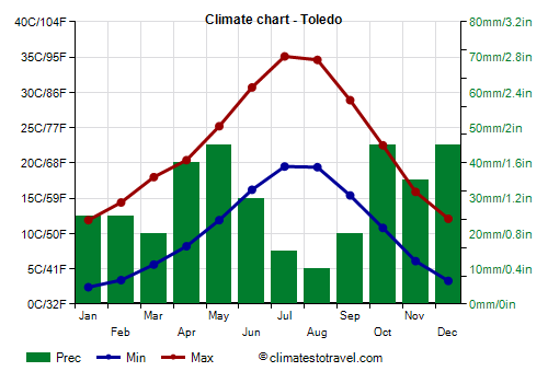
, the de facto capital of the region, is located at 515 meters (1,700 ft) above sea level. The average highs in July and August are 35 °C (95 °F), and the heat record is 44 °C (111 °F). Here are the average temperatures.
Toledo - Average temperatures (1991-2020) |
| Month | Min | Max | Mean |
|---|
| January | 2.4 | 11.9 | 7.2 |
|---|
| February | 3.4 | 14.4 | 8.9 |
|---|
| March | 5.6 | 18 | 11.8 |
|---|
| April | 8.2 | 20.4 | 14.3 |
|---|
| May | 11.9 | 25.2 | 18.6 |
|---|
| June | 16.2 | 30.7 | 23.4 |
|---|
| July | 19.5 | 35.1 | 27.3 |
|---|
| August | 19.4 | 34.6 | 27 |
|---|
| September | 15.4 | 28.9 | 22.2 |
|---|
| October | 10.8 | 22.5 | 16.6 |
|---|
| November | 6.1 | 15.9 | 11 |
|---|
| December | 3.3 | 12.1 | 7.7 |
|---|
| Year | 10.2 | 22.5 | 16.35 |
|---|
In Toledo, rainfall is scarce, as it amounts to just 350 mm (12 in) per year. In January and February, only 25 mm (1 in) of rain fall per month.
Toledo - Average precipitation| Month | Days |
|---|
| January | 25 | 5 |
|---|
| February | 25 | 5 |
|---|
| March | 20 | 4 |
|---|
| April | 40 | 7 |
|---|
| May | 45 | 7 |
|---|
| June | 30 | 4 |
|---|
| July | 15 | 1 |
|---|
| August | 10 | 2 |
|---|
| September | 20 | 3 |
|---|
| October | 45 | 6 |
|---|
| November | 35 | 6 |
|---|
| December | 45 | 7 |
|---|
| Year | 350 | 56 |
|---|
Castile-La Mancha is a sunny region. In Toledo, there are 2,900 hours of sunshine per year.
Toledo - Sunshine hours| Month | Average | Total |
|---|
| January | 5 | 150 |
|---|
| February | 6 | 170 |
|---|
| March | 7.5 | 230 |
|---|
| April | 8.5 | 250 |
|---|
| May | 9 | 285 |
|---|
| June | 11 | 335 |
|---|
| July | 12.5 | 380 |
|---|
| August | 11.5 | 350 |
|---|
| September | 8.5 | 260 |
|---|
| October | 7 | 210 |
|---|
| November | 5 | 155 |
|---|
| December | 4 | 125 |
|---|
| Year | 8 | 2910 |
|---|
The lowest altitude is reached in the western part of Castile-La Mancha, in the valley of the Tagus river. The city of Talavera de la Reina is located at 370 meters (1,200 ft), but further west, on the border with Extremadura, it drops below 300 meters (985 ft).
Continental climate
Above 600 meters (2,000 ft), and especially in the north-east of the region, the climate becomes colder, and can be defined as slightly continental.

In
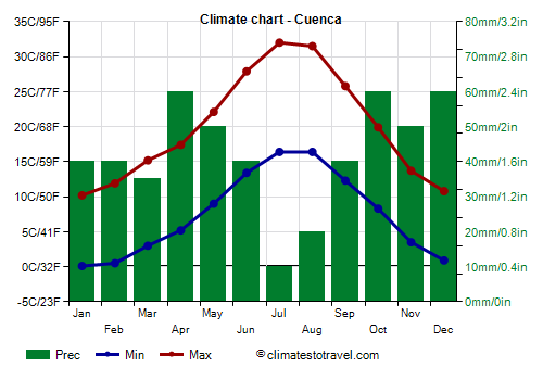
Cuenca, at an altitude of 950 meters (3,115 ft), winter is quite cold, but above all, there can sometimes be snow and frost. The cold record is -18 °C (-0.5 °F). Here too, however, the summer is hot and sunny, although less so than in Toledo and in the lower lands.
Cuenca - Average temperatures (1991-2020) |
| Month | Min | Max | Mean |
|---|
| January | 0.1 | 10.2 | 5.1 |
|---|
| February | 0.5 | 11.9 | 6.2 |
|---|
| March | 3 | 15.2 | 9.1 |
|---|
| April | 5.2 | 17.4 | 11.3 |
|---|
| May | 9 | 22.1 | 15.6 |
|---|
| June | 13.4 | 27.9 | 20.6 |
|---|
| July | 16.4 | 32 | 24.2 |
|---|
| August | 16.4 | 31.5 | 24 |
|---|
| September | 12.3 | 25.8 | 19 |
|---|
| October | 8.3 | 19.9 | 14.1 |
|---|
| November | 3.5 | 13.7 | 8.6 |
|---|
| December | 0.9 | 10.8 | 5.9 |
|---|
| Year | 7.5 | 19.9 | 13.65 |
|---|

Above 1,000 meters (3,300 ft), temperatures are even lower, and even in summer, at night it gets cool, and sometimes even cold. In the north-east of Castile-La Mancha we find an area particularly exposed to cold waves, so much so that together with the south-western part of
Aragon it is part of the so-called "frost triangle". Here, during cold spells, the temperature can drop below -20 °C (-4 °F).
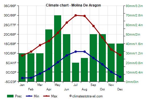
Here are the average temperatures in
Molina de Aragón, a town located at 1,065 meters (3,500 ft) above sea level.
Molina De Aragon - Average temperatures (1991-2020) |
| Month | Min | Max | Mean |
|---|
| January | -3 | 8.8 | 2.9 |
|---|
| February | -2.9 | 10.9 | 4 |
|---|
| March | -0.7 | 14.3 | 6.8 |
|---|
| April | 1.8 | 16.5 | 9.2 |
|---|
| May | 5.3 | 20.8 | 13 |
|---|
| June | 8.9 | 26.2 | 17.6 |
|---|
| July | 10.9 | 30 | 20.4 |
|---|
| August | 10.9 | 29.7 | 20.3 |
|---|
| September | 7.5 | 24.4 | 16 |
|---|
| October | 4.2 | 18.4 | 11.3 |
|---|
| November | 0.2 | 12 | 6.1 |
|---|
| December | -2.4 | 9.1 | 3.4 |
|---|
| Year | 3.4 | 18.5 | 10.9 |
|---|
Best Time
To visit Castile-La Mancha you can choose the month of May and the period from mid-September to mid-October. Those who can stand the heat can also choose summer, but must be ready to go around the cities with scorching heat.
At the higher altitudes, above 1,000 meters (3,300 ft) and in the mountains, you can choose the period from June to September. While it is true that sometimes it can be very hot, in other circumstances, at night it can be cool or even cold, so it is advisable to bring a sweatshirt or a sweater and a light jacket for the evening, and maybe a pair of gloves and a wool hat, which take up little space and can be useful on colder nights.
See also the
temperatures by month.