Select units of measurement for the temperature and rainfall tables (metric or imperial).
Average weather, temperature, rainfall, sunshine
The climate of Kiribati is
tropical, hot all year round, with considerable differences in rainfall.
In fact, the islands are scattered in the middle of the Pacific Ocean around the Equator, and span a vast area, of 4,000 kilometers (2,500 miles) from west to east, and in the central and eastern part, a strange phenomenon occurs: the islands located along the Equator receive a
cool sea current from the east, which even arrives from South America, and is able to make
the climate more arid.
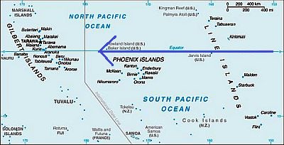 Cool current on the Kiribati Islands
The climate in detail
Gilbert Islands
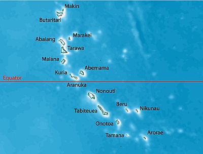 Gilbert Islands
In the west, the
Gilbert Islands (formerly Kingsmill), from which the name of the entire archipelago is derived, have an
equatorial climate, rainy throughout the year, with a rainier season from December to April and a relatively less rainy season from May to November.
Banaba Island (or Ocean Island), located apart from the others in the south-west, has a similar climate.
The rains range from 2,500 mm (98 inches) per year in the northernmost atolls (see Makin, Butaritari) to 1,500 mm (59 in) in the southern ones (see Tamana, Arorae).
South Tarawa

In the capital,
South Tarawa, in the central part of the group, at 1 degree north latitude, the daytime temperature is very stable, around 31 °C (88 °F) throughout the year.
Given the enormous distance from the continents, the records do not differ much from the averages. It never gets cold at night, and the temperature never drops below 20 °C (68 °F). On the hottest days of the year, the temperature typically reaches 33 °C (91.5 °F).
In South Tarawa, 2,000 millimeters (78 inches) of rain fall per year, with a maximum in March and a minimum in November.
The sea is warm all year round as well.
Phoenix Islands
In the central area, the
Phoenix Islands (or Rawaki), almost completely uninhabited, are more arid.
Kanton

In the only inhabited atoll, Kanton, also called Canton or Abariringa, just 500 mm (20 in) of rain fall per year, with little rainfall from October to February and moderate rainfall in the rest of the year.
Here too, however, temperatures are extremely stable throughout the year.
Line Islands
In the east, the
Line Islands, or Equatorial Sporades, almost in the middle of the Pacific Ocean, are very extended in latitude, approximately 2,000 km (1,200 mi) from the northwest to the southeast, from 5 degrees north latitude to 11 degrees south latitude).
On these islands, the amount of rainfall varies depending on the area. The
central islands, despite being near the Equator, are
semi-arid because they are affected by the cool current we mentioned above. For example, precipitation amounts to only 450 mm (17.5 in) per year on Malden Island, just south of the Equator, where it exceeds 100 mm (4 in) per month only in April and May.
The
northern islands, on the other hand, are
rainy because they lie within the Intertropical Convergence Zone. For example, rainfall amounts to 1,000 mm (40 in) per year on Christmas Island, just north of the Equator.
The rains are much more abundant to the north, on
Fanning Island (or Tabuaeran), which has a lush vegetation, and receives 2,100 mm (83 in) of rain per year. Here, however, rainfall drops below 100 mm (4 in) between September and November, but it's also acceptable in August, with 115 mm (4.5 in) of rain. More to the northwest,
Washington Island (or Teraina) is even rainier.
Continuing northwest along the line where these islands are located, we find two US-owned atolls, Palmyra and Kingman Reef, which still have an equatorial climate, hot and rainy all year round.
On the
southernmost islands (Vostok, Caroline, and Flint), at 10-11 degrees south latitude, the rains are at an intermediate level, in fact, they receive slightly more than 1,500 mm (60 in) of rain per year.
Christmas Island

On the Line Islands too, for instance in Christmas Island (or Kiritimati), temperatures are very stable.
On Christmas Island, which as mentioned is found just north of the Equator, there is a rainy period from January to July, although the rains are normally not very abundant, if not maybe in March and April.
On these eastern islands, the sea is warm all year round, even though it's just cooler than in the western ones, in fact, the water temperature is around 27/28 °C (81/82 °F).

El Niño
So far, we have talked about the average temperature and rainfall, but it must be said that the Kiribati Islands are strongly influenced by the phenomenon known as
El Niño, as well as its opposite,
La Niña.
With
El Niño, the eastern current that carries relatively cold water from South America slows down, so the climate becomes warmer and rainier than normal. On the other hand, with
La Niña, the eastern current becomes even more intense, so the climate becomes cooler and drier, leading to recurrent
drought, which in these atolls, flat and devoid of streams, can cause major problems.
In Tarawa, just 150 mm (6 in) of rain fell in the driest years, while in the wettest years, more than 4,000 mm (157 in) fell.
Tropical cyclones
Being practically at the Equator, the Kiribatis are outside of the area where
cyclones form. However, being flat islands, they can sometimes receive
anomalous waves, especially if they are combined with high tide, as happened in Tarawa, both with Cyclone Pam in March 2015 and with Cyclone Tia in November 1991 (both were cyclones of the southern hemisphere).
In theory, the southern Line Islands (Vostok, Caroline, and Flint) are located at the edge of the area where they can form, in the period from November to April, although cyclones are rare in this area.
When to go
The best time to visit the Western Kiribati Islands (i.e. the
Gilbert Islands) runs from May to November, and even more from September to November, which is the least rainy period of the year.
Being that they are drier, you can visit the
Phoenix Islands and the
central Line Islands all year round, while in the
southern Line Islands, you can avoid for safety the period from November to April because of the risk of cyclones.
What to pack
All year round, bring tropics-friendly, loose-fitting clothing, a sun hat, a scarf for the breeze, and a light sweatshirt for the evening. You can add a light raincoat or umbrella, especially on the Gilbert Islands.
Climate data - Kiribati
| Christmas Island |
|---|
|
| Jan | Feb | Mar | Apr | May | Jun | Jul | Aug | Sep | Oct | Nov | Dec |
|---|
| Min temp. | 25 | 25 | 25 | 25 | 24 | 24 | 24 | 24 | 24 | 24 | 24 | 24 |
|---|
| Max temp. | 30 | 30 | 31 | 31 | 31 | 31 | 31 | 31 | 31 | 31 | 31 | 31 |
|---|
| Precip. | 115 | 80 | 135 | 170 | 95 | 115 | 95 | 70 | 50 | 35 | 45 | 50 |
|---|
| Prec. days | 16 | 15 | 17 | 14 | 11 | 9 | 9 | 8 | 9 | 9 | 9 | 13 |
|---|
| Humidity | 82% | 82% | 83% | 84% | 81% | 79% | 78% | 78% | 78% | 77% | 79% | 79% |
|---|
| Day length | 12 | 12 | 12 | 12 | 12 | 12 | 12 | 12 | 12 | 12 | 12 | 12 |
|---|
|
|
| Kanton |
|---|
|
| Jan | Feb | Mar | Apr | May | Jun | Jul | Aug | Sep | Oct | Nov | Dec |
|---|
| Min temp. | 25 | 25 | 25 | 25 | 25 | 25 | 25 | 25 | 25 | 25 | 25 | 25 |
|---|
| Max temp. | 31 | 31 | 31 | 31 | 31 | 31 | 31 | 31 | 31 | 31 | 31 | 31 |
|---|
| Precip. | 30 | 25 | 40 | 50 | 65 | 65 | 70 | 65 | 40 | 20 | 15 | 5 |
|---|
|
|
|
|
|
| South Tarawa |
|---|
|
| Jan | Feb | Mar | Apr | May | Jun | Jul | Aug | Sep | Oct | Nov | Dec |
|---|
| Min temp. | 26 | 26 | 25 | 26 | 26 | 26 | 26 | 26 | 26 | 26 | 26 | 26 |
|---|
| Max temp. | 31 | 31 | 31 | 31 | 31 | 31 | 31 | 31 | 32 | 32 | 31 | 31 |
|---|
| Precip. | 225 | 215 | 260 | 220 | 160 | 145 | 145 | 115 | 115 | 115 | 90 | 190 |
|---|
| Prec. days | 12 | 10 | 13 | 13 | 13 | 12 | 12 | 11 | 9 | 8 | 8 | 12 |
|---|
|
|
| Sun hours | 7 | 7 | 7 | 7 | 7 | 7 | 7 | 8 | 8 | 8 | 8 | 6 |
|---|
| Sea temp | 29 | 28 | 28 | 29 | 29 | 29 | 29 | 29 | 29 | 29 | 29 | 29 |
|---|
See also the
temperatures month by month