Select units of measurement for the temperature and rainfall tables (metric or imperial).
Average weather, temperature, rainfall, sunshine hours
Index
Introduction
In Sicily, the largest island in Italy and the Mediterranean with its 25,711 square kilometers (9,927 square miles), the climate is
Mediterranean along the coasts and on the smaller islands, with mild, moderately rainy winters and hot, sunny summers.
In inland areas, on the other hand, the climate is
slightly more continental on the hills, where winters become moderately cold and summers are still hot (and often scorchingly hot), while in mountain areas, it is colder, although at the same altitude, it's certainly not as cold as in the Alps or the Apennines.
In Sicily,
precipitation is not abundant at low altitudes, since it usually ranges from 500 to 600 millimeters (20 to 23.5 inches) per year. Messina is an exception, since it receives 850 mm (33.5 in) per year. The rain pattern in Sicily is Mediterranean, with a maximum in autumn and winter, when thunderstorms are fairly frequent as well, a drop in spring, when there is already little rain, and a minimum in summer, when it rains very rarely. The landscape is often semi-arid, also because of the long summer drought, especially at low altitudes and on the southern slopes.
In the mountains, above 1,000 metres (3,300 feet), precipitation is more abundant and exceeds 1,000 mm (40 in) per year, so as to allow forests to grow.
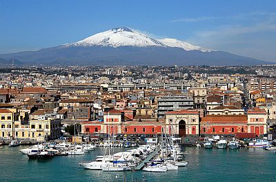
Sicily is a
sunny region. Typically, there are more than 2,600 hours of sunshine per year at low altitudes. The relatively sunniest areas are the west and south coasts.
The island is subject to the
sirocco, the hot wind from Africa, which can raise the temperature to around 20 °C (68 °F) or above in winter and 40 °C (104 °F) in summer. From June to August, during the hottest days with the sirocco, the temperature reached as high as 43 °C (109 °F) in Messina and 44/45 °C (111/113 °F) in Trapani, Palermo and Catania.
Another frequent wind is the fresh
mistral, which blows from the northwest and affects mainly the western part of the island.
In Sicily, winter
cold spells, which come from the Balkan Peninsula, usually only last two or three days, and are typically not intense along the coasts, where cold records are around 0 °C (32 °F), and snowfalls are very rare (occasionally, it can snow in Palermo and Messina, on the north coast, while on the south coast, in practice, it never snows). In the hills of the interior, however,
snow is a little more frequent, while in mountainous areas, above a thousand meters (3,300 feet), it can sometimes be abundant.
An exceptional snowfall occurred on December 31, 2014, when snow occurred in areas where it's almost never seen, such as in Cozzo Spadaro and Pachino, on the southeastern tip of the island.
Let us now have a look at the data of some cities, starting from the coasts.
Coasts and plains
In
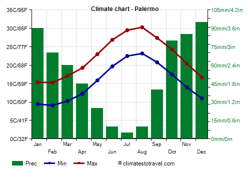
Palermo, the region's capital, overlooking the Southern Tyrrhenian Sea, there are very mild winters and hot summers, like in the rest of the Sicilian coasts. The average temperature ranges from 12 °C (54.5 °F) in February to 27 °C (80.5 °F) in August.
The city is prone to the
scirocco, which is able to increase the temperature by several degrees, but also to the
maestrale, the wind that comes from Sardinia. During the summer, when sunny days prevail, the sea breeze tempers the heat.
Palermo - Average temperatures (1991-2020) |
| Month | Min | Max | Mean |
|---|
| January | 9.5 | 15.4 | 12.4 |
|---|
| February | 9.1 | 15.3 | 12.2 |
|---|
| March | 10.3 | 17.1 | 13.7 |
|---|
| April | 12.3 | 19.3 | 15.8 |
|---|
| May | 15.9 | 23 | 19.4 |
|---|
| June | 19.7 | 26.9 | 23.3 |
|---|
| July | 22.5 | 29.5 | 26 |
|---|
| August | 23.2 | 30.3 | 26.8 |
|---|
| September | 20.8 | 27.4 | 24.1 |
|---|
| October | 17.5 | 24.3 | 20.9 |
|---|
| November | 14 | 20.4 | 17.2 |
|---|
| December | 11 | 16.7 | 13.8 |
|---|
| Year | 15.5 | 22.2 | 18.8 |
|---|
Rainfall amounts to 615 millimeters (24 in) per year, with a maximum in autumn and winter and a minimum in summer, when it almost never rains.
Palermo - Average precipitation| Month | Days |
|---|
| January | 90 | 12 |
|---|
| February | 70 | 9 |
|---|
| March | 60 | 9 |
|---|
| April | 45 | 7 |
|---|
| May | 25 | 4 |
|---|
| June | 10 | 2 |
|---|
| July | 5 | 1 |
|---|
| August | 10 | 1 |
|---|
| September | 40 | 5 |
|---|
| October | 80 | 8 |
|---|
| November | 85 | 10 |
|---|
| December | 95 | 12 |
|---|
| Year | 615 | 80 |
|---|
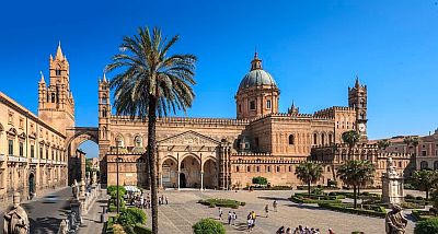
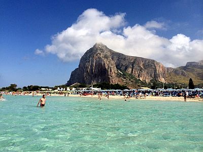
The north-western coastal towns that are located in more exposed areas, from Mondello to Isola delle Femmine, and from Terrasini to San Vito lo Capo, are a bit cooler and windier in summer, in fact, average maximum temperatures in July and August are about 28/29 °C (82/84 °F).
In
Trapani, and in other locations on the west coast (see Marsala and Mazara del Vallo) as well as in the rest of the north noast (see Cefalu, Milazzo), the climate is similar to that of Palermo.
On the
south coast of Sicily, in cities such as Sciacca, Porto Empedocle (near Agrigento), Licata, and
Gela, the climate is similar to that of Palermo and Trapani.
On the north-eastern tip of Sicily, we find
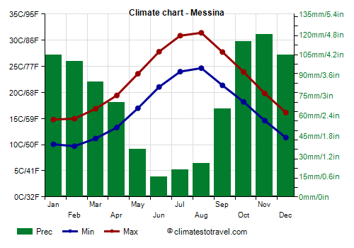
Messina, which has a particularly warm microclimate because it is closed between the strait of the same name and the Peloritani Mountains.
Messina - Average temperatures (1991-2020) |
| Month | Min | Max | Mean |
|---|
| January | 10.1 | 14.8 | 12.4 |
|---|
| February | 9.7 | 15 | 12.4 |
|---|
| March | 11.2 | 16.9 | 14 |
|---|
| April | 13.3 | 19.4 | 16.4 |
|---|
| May | 17 | 23.6 | 20.3 |
|---|
| June | 21 | 27.8 | 24.4 |
|---|
| July | 24 | 30.9 | 27.4 |
|---|
| August | 24.7 | 31.4 | 28 |
|---|
| September | 21.4 | 27.7 | 24.5 |
|---|
| October | 18.2 | 23.9 | 21.1 |
|---|
| November | 14.6 | 19.8 | 17.2 |
|---|
| December | 11.4 | 16.2 | 13.8 |
|---|
| Year | 16.4 | 22.3 | 19.35 |
|---|
For its location, Messina is also particularly rainy compared to other coastal and low-lying areas of Sicily: precipitation amounts to 850 mm (33.5 in) per year, with 100 mm (4 in) or more per month from October to February. However, here too, it rains very rarely in summer.
Messina - Average precipitation| Month | Days |
|---|
| January | 105 | 11 |
|---|
| February | 100 | 10 |
|---|
| March | 85 | 9 |
|---|
| April | 70 | 9 |
|---|
| May | 35 | 4 |
|---|
| June | 15 | 2 |
|---|
| July | 20 | 2 |
|---|
| August | 25 | 3 |
|---|
| September | 65 | 6 |
|---|
| October | 115 | 9 |
|---|
| November | 120 | 11 |
|---|
| December | 105 | 11 |
|---|
| Year | 850 | 87 |
|---|
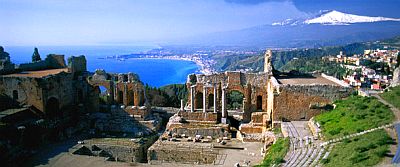
is located on the east coast, halfway between Messina and Catania, 200 meters (650 feet) above sea level, at the foot of a hill of 400 meters (1,300 feet), with panoramic views on the sea and Mount Etna in the background. Around 3 km (2 mi) south of Taormina, we find Giardini-Naxos.
On the east coast of Sicily, we find
Catania, which is located in the
Piana di Catania, the only plain of some importance of the region. Here, the temperature range is slightly higher.
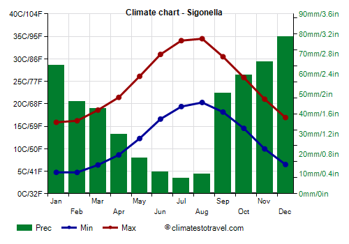
While in Catania, which lies on the coast, the average maximum temperature in July and August is 32 °C (90 °F), the interior of the plain, in summer is the hottest area in Italy, in fact the maximum temperatures in July and August reach 34/34.5 °C (93/94 °F) at Sigonella airport, and locally even 35/36 °C (95/97 °F).
The
highest records are remarkable as well: at Fontanarossa airport, the temperature reached 45 °C (113 °F) in June 1982 and 46 °C (115 °F) in July 1962. In Catenanuova, about 40 kilometers (25 miles) away from the coast and in the province of Enna, it reached as high as 48 °C (118.5 °F), though the weather station is not officially recognized.
Sigonella - Average temperatures (1991-2020) |
| Month | Min | Max | Mean |
|---|
| January | 4.8 | 15.9 | 10.3 |
|---|
| February | 4.8 | 16.2 | 10.5 |
|---|
| March | 6.4 | 18.6 | 12.5 |
|---|
| April | 8.6 | 21.4 | 15 |
|---|
| May | 12.3 | 26.1 | 19.2 |
|---|
| June | 16.6 | 31 | 23.8 |
|---|
| July | 19.4 | 34 | 26.7 |
|---|
| August | 20.3 | 34.5 | 27.4 |
|---|
| September | 18.2 | 30.5 | 24.3 |
|---|
| October | 14.6 | 25.8 | 20.2 |
|---|
| November | 10 | 21 | 15.5 |
|---|
| December | 6.5 | 17 | 11.7 |
|---|
| Year | 11.9 | 24.4 | 18.1 |
|---|
South of Catania, and still on the east coast, we find
Syracuse, where the climate is similar, although the night temperatures are slightly higher.
Sea temperature
The
sea in Sicily is warm enough for swimming from July to September. In June, the sea is still a bit cool, while in October, after the summer, the water temperature is still decent, around 22.5 °C (72.5 °F): on fine days, perhaps when the sirocco blows, locals go to the beach.
Palermo - Sea temperature| Month |
|---|
| January | 15 |
|---|
| February | 14.5 |
|---|
| March | 14.5 |
|---|
| April | 15.5 |
|---|
| May | 18.5 |
|---|
| June | 22 |
|---|
| July | 25.5 |
|---|
| August | 26.5 |
|---|
| September | 25 |
|---|
| October | 22.5 |
|---|
| November | 19.5"> |
|---|
| December | 16.5 |
|---|
| Year | 19.7 |
|---|
Smaller islands
Around Sicily, there are some small archipelagos and smaller islands. Off the western coast, between Trapani and Marsala, we find the
Aegadian Islands, while closer to the coast we find the
Stagnone islands.
On the Tyrrhenian Sea, north of Palermo we find the island of
Ustica, while to the north-east we find the
Aeolian Islands.
To the southwest, in the Strait of Sicily, we find
Pantelleria, and further south the
Pelagie islands:
Lampedusa (the southernmost point of Italy) and Linosa.
These islands have a very mild climate, similar to that of the coasts, but also windy. Rainfall amounts to about 500 mm (20 in) a year, except in the Pelagie Islands, which are drier.
Inland areas
With the exception of the aforementioned plain of Catania, the interior of Sicily is occupied by
hills and mountains.
Here, winter gradually becomes colder with increasing altitude, and above 800 meters (2,600 feet), and sometimes as low as 500 meters (1,600 feet), it can
snow during cold spells. Sometimes,
fog can form.
In summer, on the other hand, a peculiar phenomenon occurs: in the first few hundred meters of altitude, the temperature does not decrease, actually, it can be even higher than on the coasts, since the mild influence of the sea is absent or reduced here, so there are often
very hot days.
Precipitation in this area is generally quite low, around or below 500 mm (20 in) per year, while it increases again at higher altitudes, above 1,000 meters (3,300 feet). As always, however, summer is the driest season.
For example, in
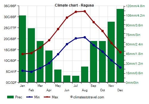
Ragusa, the capital of the southernmost province of Italy, located at 500 meters (1,600 feet) above sea level, the average temperature ranges from 9 °C (48 °F) in January and February to 26.5 °C (79.5 °F) in August.
Ragusa - Average temperatures (1991-2019) |
| Month | Min | Max | Mean |
|---|
| January | 5.4 | 13 | 9.2 |
|---|
| February | 4.9 | 13.4 | 9.2 |
|---|
| March | 6.6 | 16 | 11.3 |
|---|
| April | 8.9 | 19.3 | 14.1 |
|---|
| May | 12.9 | 24.4 | 18.7 |
|---|
| June | 17.6 | 29.7 | 23.6 |
|---|
| July | 20.2 | 32.3 | 26.3 |
|---|
| August | 20.7 | 32.6 | 26.6 |
|---|
| September | 17.1 | 27.6 | 22.3 |
|---|
| October | 14.1 | 23.6 | 18.8 |
|---|
| November | 10.1 | 18 | 14.1 |
|---|
| December | 6.9 | 13.8 | 10.4 |
|---|
| Year | 12.2 | 22 | 17.05 |
|---|
In
Caltanissetta, at 570 meters (1,870 feet) above sea level, the temperatures are very similar to those of Ragusa.
To find lower temperatures also in summer, we have to climb further in altitude.
In
Enna, the highest provincial capital of Italy, located in the center of Sicily and at about 900 meters (3,000 feet) of altitude, fog often forms in autumn and winter, while the heat is generally bearable in summer, althoug the temperature can reach 35/36 °C (95/97 °F) when the sirocco blows. In winter, during cold spells, sometimes it can snow and freeze.
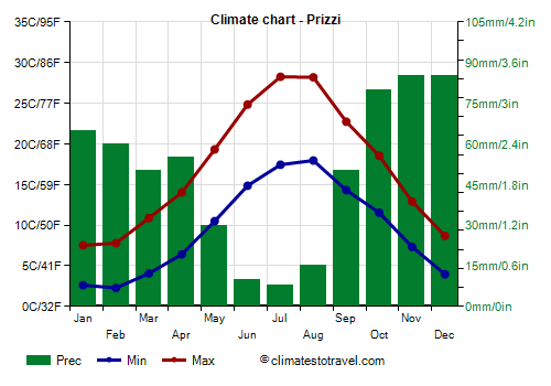
In
Prizzi, located further to the west, at 1,000 meters (3,300 feet) above sea level, the average temperature ranges from 5 °C (41 °F) in January and February to 23 °C (73.5 °F) in July and August.
Prizzi - Average temperatures (1991-2017) |
| Month | Min | Max | Mean |
|---|
| January | 2.6 | 7.5 | 5.1 |
|---|
| February | 2.3 | 7.8 | 5 |
|---|
| March | 4.1 | 10.9 | 7.5 |
|---|
| April | 6.4 | 14 | 10.2 |
|---|
| May | 10.5 | 19.3 | 14.9 |
|---|
| June | 14.9 | 24.8 | 19.8 |
|---|
| July | 17.4 | 28.3 | 22.8 |
|---|
| August | 18 | 28.2 | 23.1 |
|---|
| September | 14.3 | 22.7 | 18.5 |
|---|
| October | 11.5 | 18.5 | 15 |
|---|
| November | 7.3 | 12.9 | 10.1 |
|---|
| December | 4 | 8.7 | 6.3 |
|---|
| Year | 9.5 | 17 | 13.25 |
|---|
On average, 600 mm (23.5 in) of rain fall per year, as usual, with a maximum in autumn and winter and a minimum in summer.
Prizzi - Average precipitation| Month | Days |
|---|
| January | 65 | 10 |
|---|
| February | 60 | 9 |
|---|
| March | 50 | 8 |
|---|
| April | 55 | 8 |
|---|
| May | 30 | 4 |
|---|
| June | 10 | 2 |
|---|
| July | 8 | 1 |
|---|
| August | 15 | 2 |
|---|
| September | 50 | 5 |
|---|
| October | 80 | 8 |
|---|
| November | 85 | 10 |
|---|
| December | 85 | 11 |
|---|
| Year | 600 | 78 |
|---|
Etna and mountains
Most of the mountain ranges exceeding 1,000 meters (3,300 feet) are located in the north and east of the island. In particular, in the north, we find some mountain ranges parallel to the coast: the
Madonie, whose highest peak is Pizzo Carbonara, 1,979 meters (6,493 feet) high, the
Nebrodi, whose highest peak is Mount Soro, 1,847 meters (6,060 feet) high, and, west of Messina, the
Peloritani, which reach 1,374 meters (4,419 ft).
On
Mount Soro, which can also give us an indication of the values found at about 1,850 meters (6,050 ft) on Mount Etna, the average temperature ranges from -0.5 °C (31 °F) in February to 17.5 °C (63.5 °F) in August. In winter, during the most intense cold spells, the temperature can drop to around -10 °C (14 °F), while in summer, during heatwaves, it can reach around 30 °C (86 °F).
Monte Soro - Average temperatures (2003-2020) |
| Month | Min | Max | Mean |
|---|
| January | -2.9 | 3 | 0 |
|---|
| February | -3.9 | 2.7 | -0.6 |
|---|
| March | -1.3 | 5.9 | 2.3 |
|---|
| April | 1.9 | 9.5 | 5.7 |
|---|
| May | 5.3 | 13.7 | 9.5 |
|---|
| June | 9.5 | 18.4 | 14 |
|---|
| July | 11.8 | 21.5 | 16.6 |
|---|
| August | 12.3 | 22.3 | 17.3 |
|---|
| September | 8.9 | 17.1 | 13 |
|---|
| October | 6.4 | 13.8 | 10.1 |
|---|
| November | 2.3 | 8.5 | 5.4 |
|---|
| December | -1.3 | 4.1 | 1.4 |
|---|
| Year | 4.1 | 11.8 | 7.95 |
|---|
The highest mountain in Sicily is
Etna volcano, 3,357 meters (10,921 feet) high and located in the eastern part of the island. The summit, which is located just 25 km (15 mi) away from Catania, in winter (and often also in spring and autumn), is covered with snow.
In the center and south of the region, there are mostly hills and low mountains, which reach about 1,000 meters (3,300 feet) above sea level, with the exception of the Sicani Mountains, about 30 km (18 mi) south of Palermo, which reach 1,613 meters (5,292 ft) in the highest peak, Rocca Busambra.
Best Time
The
best time to visit Sicily for a beach holiday is the summer, from June to August. The sea temperature is comfortable enough from July to September, although in September, which in any case is still a good month (especially in the first half), the first periods of bad weather begin to occur. In June, as mentioned, the sea is still a bit cool, while in May, it is even cold, and sometimes, the air can also be a little cool for sunbathing.
April and May are advisable months for
hiking and visiting cities, while in summer, it can sometimes be too hot to get around with ease. In October, the temperatures are mild or pleasantly warm, but the days are shorter and the weather can be rainy and windy.
See also the
temperatures by month.