Select units of measurement for the temperature and rainfall tables (metric or imperial).
Average weather, temperature, rainfall, sunshine hours

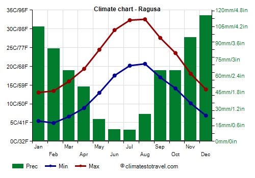
The climate of Ragusa is
Mediterranean, with mild, rainy winters and hot, sunny summers.
The city is the southernmost provincial capital of Italy and is located in the south-east of Sicily, at an altitude ranging between 500 and 600 meters (1,650 and 2,000 feet). The weather station is located at 515 meters (1,700 ft). However, the oldest district, Ragusa Ibla, is 400 at meters (1,300 ft).
To the west we find the cities of Comiso, at an altitude of 200 metres (650 ft), and Vittoria, at 175 metres (575 ft).
The coast, where we find Marina di Ragusa, is about 18 km (12 mi) to the south.
Winter, from December to February, is mild, and is characterized by sunny periods alternating with rainy periods.
Temperatures are a little lower than at sea level, and during cold air irruptions, the cold is felt more. However, the temperature rarely drops below freezing. In February 2008 it dropped to -5 °C (23 °F).
Snow in Ragusa is rare, however, it is less rare than at sea level. Once every few years there may be a snowfall, with an accumulation of a few centimeters (1 in = 2.5 cm), especially in the upper part of the city.
On the coast, snow is even more rare, however, in January 1999 and in December 2014, it snowed even in Marina di Ragusa.
 Summer
, from June to August, is hot and sunny, with very rare rains.
Despite the altitude, it is often hot. Furthermore,
heatwaves of African origin can sometimes occur: in these cases, it is possible for the temperature to reach or exceed 40 °C (104 °F). In August 1999, the temperature reached 43 °C (109.5 °F).
Best Time
To visit Ragusa, you can choose the periods from mid-April to mid-May and from mid-September to mid-October, since in summer it can get very hot. It must be said that in both periods there may be rainy days.
The best months for a
beach holiday on the coast are July and August. In June, the days are longer and the weather is often good, but the sea is still a bit cool. You can still go in September, in fact the sea is still quite warm, but the days get shorter and the first waves of bad weather can occur, especially in the second half of the month.
Ragusa - Climate data
In Ragusa, the
average temperature of the coldest month (February) is of
9.2 °C, that of the warmest month (August) is of
26.6 °C. Here are the average temperatures.
Ragusa - Average temperatures (1991-2019) |
| Month | Min | Max | Mean |
|---|
| January | 5.4 | 13 | 9.2 |
|---|
| February | 4.9 | 13.4 | 9.2 |
|---|
| March | 6.6 | 16 | 11.3 |
|---|
| April | 8.9 | 19.3 | 14.1 |
|---|
| May | 12.9 | 24.4 | 18.7 |
|---|
| June | 17.6 | 29.7 | 23.6 |
|---|
| July | 20.2 | 32.3 | 26.3 |
|---|
| August | 20.7 | 32.6 | 26.6 |
|---|
| September | 17.1 | 27.6 | 22.3 |
|---|
| October | 14.1 | 23.6 | 18.8 |
|---|
| November | 10.1 | 18 | 14.1 |
|---|
| December | 6.9 | 13.8 | 10.4 |
|---|
| Year | 12.2 | 22 | 17.05 |
|---|
amounts to
715 millimeters per year: so, it is at an intermediate level. It ranges from
10.5 millimeters in the driest month (July) to
115 millimeters in the wettest one (December). Here is the average precipitation.
Ragusa - Average precipitation| Month | Days |
|---|
| January | 105 | 11 |
|---|
| February | 85 | 10 |
|---|
| March | 65 | 9 |
|---|
| April | 50 | 9 |
|---|
| May | 20 | 4 |
|---|
| June | 11 | 2 |
|---|
| July | 11 | 2 |
|---|
| August | 25 | 3 |
|---|
| September | 65 | 6 |
|---|
| October | 65 | 9 |
|---|
| November | 95 | 11 |
|---|
| December | 115 | 11 |
|---|
| Year | 715 | 87 |
|---|