Select units of measurement for the temperature and rainfall tables (metric or imperial).
Average weather, temperature, rainfall, sunshine hours
Emilia-Romagna is a region of northern Italy, stretched from west to east, and occupied by the
Po Valley in the central-northern area and by the
Apennines in the southern part. In the east, the region overlooks the
Northern Adriatic Sea. The
Po river flows in the north and marks the border with Lombardy to the west and Veneto to the east.
Romagna occupies the south-eastern part of the region, and reproduces the same characteristics in small, with a coastal, a flat and a mountainous part.
In the plain, the climate is of the
semi-continental type, with cold, humid winters and hot, sultry summers, especially in the central-western part. The eastern area is a little milder, due to the influence of the sea.
On the Apennines, the climate is
temperate humid at intermediate altitudes and cold in the high mountains.
Plain
In
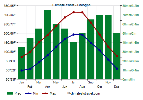
Bologna, the capital, located in the central-eastern part of the region, the average temperature ranges from 3.5 °C (38.5 °F) in January to 25.5 °C (78 °F) in July and August. Here are the average temperatures.
Bologna - Average temperatures (1991-2020) |
| Month | Min | Max | Mean |
|---|
| January | -0.2 | 7.2 | 3.5 |
|---|
| February | 0.7 | 9.9 | 5.3 |
|---|
| March | 4.3 | 15.2 | 9.7 |
|---|
| April | 8.1 | 19.1 | 13.6 |
|---|
| May | 12.7 | 24 | 18.4 |
|---|
| June | 17 | 28.6 | 22.8 |
|---|
| July | 19.3 | 31.5 | 25.4 |
|---|
| August | 19.2 | 31.4 | 25.3 |
|---|
| September | 14.9 | 25.8 | 20.4 |
|---|
| October | 10.8 | 19.3 | 15.1 |
|---|
| November | 5.7 | 12.8 | 9.2 |
|---|
| December | 0.8 | 7.7 | 4.3 |
|---|
| Year | 9.5 | 19.4 | 14.45 |
|---|
in the plains is not abundant, and is slightly more scarce in the eastern and northern part, far from the Apennines, where it amounts to about 650 millimeters (25.5 inches) a year, and more abundant in the western part (v.
Piacenza,
Parma), where it exceeds 700 mm (27.5 in) a year. In general, the rainiest seasons are spring and autumn, while in winter and in summer the rains decrease a little.
Here is the average precipitation in Bologna.
Bologna - Average precipitation| Month | Days |
|---|
| January | 35 | 6 |
|---|
| February | 45 | 6 |
|---|
| March | 55 | 7 |
|---|
| April | 75 | 8 |
|---|
| May | 60 | 8 |
|---|
| June | 55 | 6 |
|---|
| July | 40 | 4 |
|---|
| August | 50 | 5 |
|---|
| September | 65 | 5 |
|---|
| October | 70 | 7 |
|---|
| November | 70 | 6 |
|---|
| December | 50 | 6 |
|---|
| Year | 670 | 75 |
|---|
The seasons
In
winter, from December to February, the western part (see Piacenza, Parma), is more cold, foggy and cloudy, and the wind is often weak or absent. The eastern part (
Ferrara province and Romagna) can instead receive both the sirocco, the warm wind from the south-east, and the bora, the cold wind from the north-east. Traveling along the Aemilian Way (Via Emilia) from north-west to the south-east, the average temperature of January is 2.8 °C (37 °F) to Piacenza, 3.5 °C (38 °F) in Bologna, 4.5 °C (40 °F) in Forlì and 4.7 °C (40.5 °F) in Rimini.
During
cold waves, which are becoming rarer due to global warming, the temperature can drop to -10 °C (14 °F) or even less. In general, the lowest temperatures are recorded in the western provinces (Piacenza and Parma), where cold air stagnates more. In January 1985, the temperature dropped to -15 °C (5 °F) on the Adriatic coast and to -20/-25 °C (-13/-4 °F) in the rest of the plain.
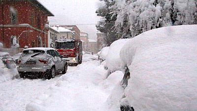
Snow is more frequent in the western part of Emilia-Romagna than in the eastern one, but in the latter, sometimes there can be abundant snowfall, during the most intense cold waves (thanks to a phenomenon similar to the Lake-Effect Snow that occurs in the Great Lakes of North America). In addition, it snows more in the cities located along the Via Emilia, which are close to the Apennines, than in the low plain, where the Po flows.
Traveling along the Via Emilia from north-west to the south-east, on average, more than 40 cm (15.5 inches) per year of snow fall in Piacenza, about 30 cm (12 in) in Parma, Reggio Emilia, Modena and Bologna, about 25 cm (10 in) in Forlì and Cesena, and 20 cm (8 in) in Rimini.
During the great snowfalls of February 1929 and February 2012, more than one meter (39 in) of snow fell in the Romagna plain, especially between Forlì and Cesena.
In
summer, from June to August, Emilia-Romagna is the hottest and driest region in Northern Italy. Sometimes, thunderstorms can burst, but less often than in the part of the Po Valley north of the Po (see Lombardy, Veneto).
The average temperature of July and August ranges from 24/24.5 °C (75/76 °F) on the coast (see
Cervia,
Rimini) to almost 26 °C (79 °F) in the central area (see Reggio Emilia, Modena, Ferrara).
There is often
oppressive heat in the lower Po Valley, far from the sea and the Apennines. The highest temperatures are recorded in the central-western part, at a certain distance from the sea, around Ferrara and in the lower plain of the provinces of Modena and Bologna. In this area, the heat records are slightly higher than 40 °C (104 °F).
In
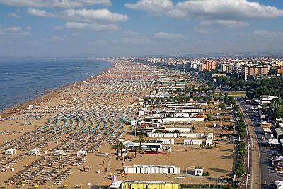
Romagna, on the other hand, the sea breeze makes the heat decidedly more bearable, except in the few days in which the sirocco blows.
The
sea on the Romagna coast is warm enough to swim in from July to September, while in June it is still a little cool.
In winter, the sea temperature drops to 10.5/11 °C (51/52 °F) in February and March, however, being a small and shallow sea, the upper Adriatic can heat up or cool down depending on the weather conditions.
Here is the average sea temperature in Rimini.
Rimini - Sea temperature| Month |
|---|
| January | 12 |
|---|
| February | 10.5 |
|---|
| March | 11 |
|---|
| April | 13.5 |
|---|
| May | 18 |
|---|
| June | 22.5 |
|---|
| July | 25.5 |
|---|
| August | 26 |
|---|
| September | 23.5 |
|---|
| October | 20 |
|---|
| November | 16.5"> |
|---|
| December | 14 |
|---|
| Year | 17.8 |
|---|
Apennines
On the Tuscan-Emilian Apennines, the temperatures decrease with increasing altitude, moreover, precipitation becomes more abundant, and in certain areas it exceeds 1,500 mm (59 in) per year. In winter, abundant
snowfalls may occur, while in the summer, afternoon thunderstorms are more frequent than in the plains. Even the
wind blows more often, and can be strong, especially on the mountain ridge, where mild, humid air can arrive from the Tyrrhenian Sea.
In
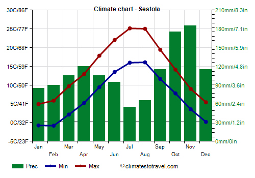
Sestola, located at 1,000 meters (3,300 feet) above sea level in the Modenese Apennines, the average temperature ranges from 2 °C (35.5 °F) in January to 20.5 °C (69 °F) in July and August.
Sestola - Average temperatures (1991-2020) |
| Month | Min | Max | Mean |
|---|
| January | -0.8 | 4.9 | 2.1 |
|---|
| February | -0.8 | 5.9 | 2.5 |
|---|
| March | 2.2 | 9.7 | 5.9 |
|---|
| April | 5.2 | 12.9 | 9.1 |
|---|
| May | 9.4 | 17.8 | 13.6 |
|---|
| June | 13.5 | 22 | 17.8 |
|---|
| July | 16 | 25.1 | 20.6 |
|---|
| August | 16.1 | 25 | 20.5 |
|---|
| September | 11.6 | 19.4 | 15.5 |
|---|
| October | 7.8 | 14.1 | 11 |
|---|
| November | 3.6 | 9 | 6.3 |
|---|
| December | 0.2 | 5.4 | 2.8 |
|---|
| Year | 7 | 14.3 | 10.65 |
|---|
On average, 1,300 mm (51 in) of rain per year fall. In winter, snowfalls can be abundant, and on average, they amount to more than two meters (78.5 in) per year.
Sestola - Average precipitation| Month | Days |
|---|
| January | 85 | 9 |
|---|
| February | 90 | 8 |
|---|
| March | 105 | 9 |
|---|
| April | 120 | 11 |
|---|
| May | 105 | 10 |
|---|
| June | 95 | 8 |
|---|
| July | 55 | 5 |
|---|
| August | 65 | 6 |
|---|
| September | 115 | 8 |
|---|
| October | 175 | 10 |
|---|
| November | 185 | 13 |
|---|
| December | 115 | 10 |
|---|
| Year | 1300 | 106 |
|---|
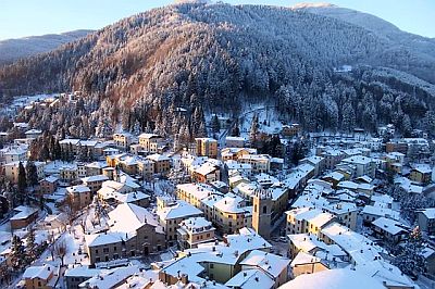
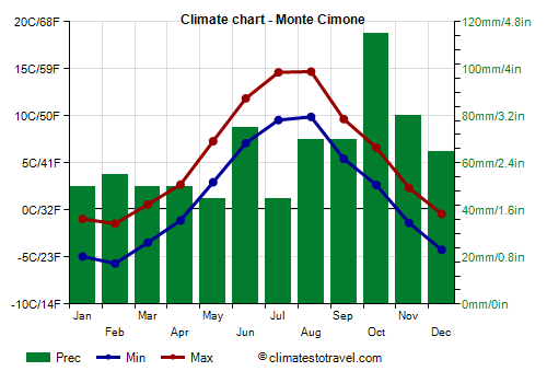
With its 2,165 meters (7,102 ft), the highest peak of the northern Apennines is
Mount Cimone. The daily average remains below freezing even during the day from December to March, while in July and August it just exceeds 12 °C (53.5 °F).
Monte Cimone - Average temperatures (1991-2020) |
| Month | Min | Max | Mean |
|---|
| January | -4.9 | -1 | -2.9 |
|---|
| February | -5.7 | -1.4 | -3.6 |
|---|
| March | -3.5 | 0.6 | -1.4 |
|---|
| April | -1.1 | 2.7 | 0.8 |
|---|
| May | 3 | 7.3 | 5.1 |
|---|
| June | 7.1 | 11.9 | 9.5 |
|---|
| July | 9.6 | 14.6 | 12.1 |
|---|
| August | 9.9 | 14.7 | 12.3 |
|---|
| September | 5.4 | 9.7 | 7.6 |
|---|
| October | 2.7 | 6.6 | 4.6 |
|---|
| November | -1.4 | 2.4 | 0.5 |
|---|
| December | -4.2 | -0.4 | -2.3 |
|---|
| Year | 1.4 | 5.7 | 3.55 |
|---|
On average, 770 mm (30 in) of rain or snow fall per year. The peak may still be covered in snow in May.
Best Time
To visit the
cities located in the plain, you can go from mid-April to mid-June. September is also a good month. However, you have to take into account a few rainy days on both periods. In summer it can be very hot, while winter is often cold and humid, with poor sunshine and sometimes fog.
For a
beach holiday on the Riviera Romagnola, you can go to the summer, from June to August, with a preference for July and August, given that they are the warmest and sunniest months, and in which the sea is also warmer.
On the
Apennines you can go both in winter, perhaps to ski, and in summer, perhaps to trek in the mountains and to escape the heat of the plain. In winter, on the ski slopes there is not always snow, especially in November and December, that is, at the beginning of the season.
See also the
temperatures by month.