Select units of measurement for the temperature and rainfall tables (metric or imperial).
Average weather, temperature, rainfall, sunshine
In Slovenia, there is a clear separation between the
western flat area, stretched from Nova Gorica to northern Istria, which has a quite mild climate, and the
interior, which has a moderately continental climate (in the hills, the valley bottoms and the eastern plain) or a cold mountain climate (in the mountains).
Precipitation (rain or snow) is abundant in the western part of the country, where it ranges between 1,000 and 1,500 millimeters (40 and 60 inches) per year in plains and hills, while it exceeds 2,000 mm (80 in) in the mountains, and even 3,000 mm (120 in) on the most exposed slopes. Only in plains and hills of the far east, precipitation is less abundant, and decreases below 900 mm (35.5 in).
The climate in detail
The western plain
About 30 kilometers (18 miles) away from the coast, there is a mountain range that separates the interior from the sea, so the
western plains of Slovenia that are influenced by the sea are not vast.
This flat area close to the coast has a climate that can be described as
transitional Mediterranean.
In fact,
winter is quite mild in cities such as Portoroz, Piran, Izola, Koper, though you cannot fully define it as Mediterranean, since the average temperature in January is around 5/6 °C (41/43 °F).
In addition, this area is exposed to a fearful wind: the temperature undergoes sudden drops when the
Bora makes its appearance, that is, a cold and furious wind which blows more often in the cold half of the year and which can be accompanied by clear skies (light Bora) or more rarely by cloudy skies, with rain or snow (dark Bora).
Since the Bora comes from the plains of Eastern Europe, it is usually dry, so,
snow in this area is rare and usually not abundant.
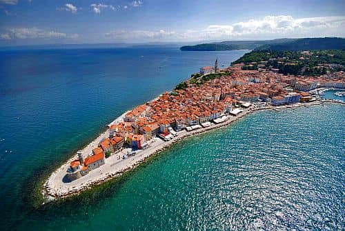 Summer
 in the western plain is warm or even hot, averaging around 23 °C (73 °F) in July and August, though it's tempered by the breeze.
The
rains are frequent throughout the year, with a maximum in autumn (September to November), a relative minimum in winter, and an increase between late spring and summer.
This is not to say that summer is a bad season, but you have to take into account some thunderstorms in the afternoon, and even a few days when Atlantic disturbances manage to move over the country, maybe accompanied with some cool gusts of Bora.
Portoroz
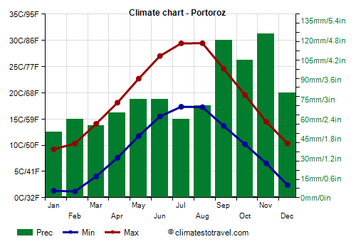
In
Portoroz, located on the coast of the northern Adriatic Sea, on the Gulf of Trieste, the average temperature ranges from around 5.5 °C (42 °F) in January to around 23.5 °C (74 °F) in July and August.
Rainfall is fairly abundant, around 950 millimeters (37.5 inches) per year, and it is well distributed throughout the year, in fact, there can be some rain even in summer, often in the form of thunderstorms. However, the rainiest season is autumn.
In Portoroz and along the Adriatic Coast, the sun does not shine very often in winter, while it frequently shines in summer.
The
sea temperature is high enough for swimming in July and August, but all in all, even in September.
In the cities that are not located right on the coast, the winter is a bit colder, as is the case of
Nova Gorica and Ajdovscina, but the average is still above freezing, around 4/5 °C (39/41 °F) in January.
Inland areas
As soon as you move towards the
interior, you will find some elevations, which are able to reduce the mild influence of the Adriatic Sea. Already in
Postojna, located in the Karst Plateau, at 530 meters (1,700 feet) above sea level, winter is cold and snowy, while summer can be hot during the day, but nights remain cool. Rainfall is abundant throughout the year, with a relative decrease only in January, February, and July; in autumn, it can sometimes be torrential.
Ljubljana
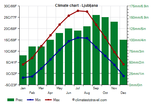
In
Ljubljana, at 300 meters (1,000 feet) above sea level, the monthly average temperature ranges from 1 °C (34 °F) in January to 22 °C (71.5 °F) in July. In winter, snow often falls, while in summer, there is a moderate amount of afternoon thunderstorms, although the sun shines quite often. In winter, there are frequent fogs when the weather is stable, while cold waves from Russia can bring intense frosts; in summer, there can be short heat waves, with peaks of 35 °C (95 °F).
Rainfall is abundant here as well, about 1,370 mm (54 in) per year, in fact, it is one of the rainiest capitals in Europe.
The sun in Ljubljana is rarely seen in winter, while in summer, it shines quite often, though not as often as along the coast.
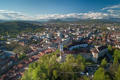
Across the
central and eastern part of Slovenia, the climate is similar to that of Ljubljana, and the differences are mainly due to the altitude.
Going to the east, however, annual
precipitation gradually decreases: in
Maribor, it drops to 895 mm (35 in), mainly because autumn and winter are relatively less rainy, while summer equally receives its load of thunderstorms. This applies to the entire eastern area, from Maribor to the north-eastern flat area, on the border with Austria and Hungary.
Mountains
In
high mountains, the climate is naturally colder. Snowfalls are especially abundant in the mountains of western Slovenia, on both the northern Alpine sector and in the massif to the south, which, not coincidentally, is called "snowy mountain" (Snežnik).
Kranjska Gora
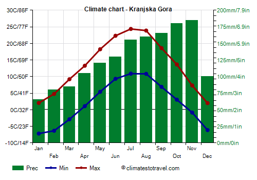
In
Kranjska Gora, a ski resort near the border with Austria, 800 meters (2,600 feet) above sea level, , the average temperature ranges from around -2.5 °C (27.5 °F) in January to around 17.5 °C (63.5 °F) in July and August.
On average, 1,450 mm (58 in) of rain or snow fall per year, and even more in the mountains that surround it. Here, strong afternoon thunderstorms can occur in summer, as well as heavy rains in autumn, especially in October.
South of Kranjska Gora, we find mountains exceeding 2,500 meters (8,200 feet). The highest mountain in Slovenia and the Julian Alps is
Triglav (Tricorno), 2,864 meters (9,396 feet) high. In the area, there is also a glacier, now in retreat due to global warming.
Kredarica
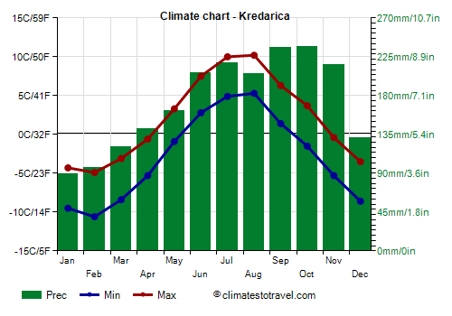
Near a peak in the vicinity, mount
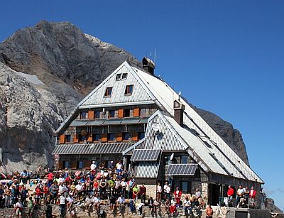
Kredarica, there is a meteorologic station at 2,500 meters (8,200 ft), at the Triglav Lodge. The snow reaches its maximum height in April (3.2 meters or 10.5 feet), in June it is still a meter (3.3 ft) high on average, while it has completely melted by August. Record low and high temperature are respectively -28 °C (-18.5 °F) and 21.5 °C (70.5 °F).
When to go
The short coastline of Slovenia is good for a
beach holiday in summer, especially in July and August, even though there can be some cool and rainy days, or some afternoon thunderstorms.
You can visit the
interior from June to September, bearing in mind, however, that the rains may sometimes be heavy even in summer in the western areas, such as in Ljubljana or Postunia. In July and August, every so often, periods of intense heat may occur, so if you don't like the heat, you may prefer June and September.
In the mountain resorts, there is almost always enough snow. In February, the days are longer than in the Christmas period, so it can preferable for a ski holiday.
What to pack
In
winter: in the interior, bring warm clothes, such as a sweater, a down jacket, a scarf, gloves, and an umbrella. On the coast, bring warm clothes, a jacket, a raincoat or umbrella, but also a hat, a scarf, and gloves for the days with Bora.
In
summer: bring light clothes, T-shirts and shorts, but also long pants, a jacket and a sweatshirt for the evening or for cooler days; a raincoat or umbrella. In the mountains, bring hiking shoes, sunscreen and sunglasses.
Climate data - Slovenia
| Celje (240 meters) |
|---|
|
| Jan | Feb | Mar | Apr | May | Jun | Jul | Aug | Sep | Oct | Nov | Dec |
|---|
| Min temp. | -4 | -4 | 0 | 4 | 9 | 13 | 14 | 14 | 10 | 6 | 2 | -3 |
|---|
| Max temp. | 5 | 7 | 12 | 17 | 22 | 26 | 28 | 27 | 22 | 16 | 10 | 5 |
|---|
| Precip. | 45 | 60 | 60 | 75 | 95 | 120 | 125 | 115 | 130 | 115 | 100 | 80 |
|---|
| Prec. days | 6 | 6 | 7 | 9 | 10 | 10 | 10 | 9 | 10 | 8 | 8 | 8 |
|---|
| Humidity | 82% | 79% | 75% | 72% | 74% | 76% | 76% | 79% | 82% | 83% | 83% | 83% |
|---|
| Day length | 9 | 10 | 12 | 14 | 15 | 16 | 15 | 14 | 12 | 11 | 9 | 9 |
|---|
| Sun hours | 3 | 4 | 5 | 6 | 7 | 8 | 8 | 8 | 6 | 4 | 2 | 2 |
|---|
|
| Koper |
|---|
|
| Jan | Feb | Mar | Apr | May | Jun | Jul | Aug | Sep | Oct | Nov | Dec |
|---|
| Min temp. | 3 | 4 | 7 | 10 | 14 | 18 | 20 | 20 | 16 | 12 | 8 | 4 |
|---|
| Max temp. | 9 | 10 | 14 | 18 | 23 | 27 | 30 | 30 | 25 | 20 | 15 | 10 |
|---|
| Precip. | 50 | 60 | 55 | 65 | 80 | 90 | 70 | 70 | 125 | 120 | 120 | 85 |
|---|
| Prec. days | 6 | 6 | 6 | 7 | 8 | 7 | 6 | 6 | 8 | 8 | 9 | 8 |
|---|
|
|
|
|
| Kranjska Gora (800 meters) |
|---|
|
| Jan | Feb | Mar | Apr | May | Jun | Jul | Aug | Sep | Oct | Nov | Dec |
|---|
| Min temp. | -7 | -6 | -3 | 1 | 5 | 9 | 11 | 11 | 7 | 3 | -1 | -6 |
|---|
| Max temp. | 2 | 5 | 9 | 13 | 18 | 22 | 24 | 24 | 19 | 14 | 7 | 2 |
|---|
| Precip. | 65 | 80 | 85 | 105 | 120 | 130 | 155 | 160 | 165 | 180 | 185 | 100 |
|---|
| Prec. days | 6 | 6 | 8 | 11 | 12 | 11 | 11 | 11 | 9 | 9 | 10 | 8 |
|---|
|
| Day length | 9 | 10 | 12 | 14 | 15 | 16 | 15 | 14 | 12 | 11 | 9 | 9 |
|---|
| Sun hours | 3 | 4 | 5 | 6 | 6 | 7 | 8 | 8 | 6 | 4 | 2 | 2 |
|---|
|
| Kredarica (2,500 meters) |
|---|
|
| Jan | Feb | Mar | Apr | May | Jun | Jul | Aug | Sep | Oct | Nov | Dec |
|---|
| Min temp. | -10 | -11 | -8 | -5 | -1 | 3 | 5 | 5 | 1 | -2 | -5 | -9 |
|---|
| Max temp. | -4 | -5 | -3 | -1 | 3 | 8 | 10 | 10 | 6 | 4 | 0 | -4 |
|---|
| Precip. | 90 | 95 | 120 | 140 | 160 | 205 | 220 | 205 | 235 | 235 | 215 | 130 |
|---|
| Prec. days | 9 | 9 | 11 | 14 | 15 | 15 | 14 | 13 | 12 | 12 | 12 | 10 |
|---|
|
|
| Sun hours | 4 | 4 | 5 | 5 | 5 | 6 | 6 | 6 | 5 | 4 | 3 | 4 |
|---|
|
| Ljubljana (300 meters) |
|---|
|
| Jan | Feb | Mar | Apr | May | Jun | Jul | Aug | Sep | Oct | Nov | Dec |
|---|
| Min temp. | -2 | -1 | 2 | 6 | 11 | 14 | 16 | 16 | 12 | 8 | 4 | -1 |
|---|
| Max temp. | 4 | 7 | 12 | 17 | 22 | 26 | 28 | 28 | 22 | 16 | 10 | 4 |
|---|
| Precip. | 65 | 85 | 85 | 100 | 115 | 125 | 120 | 130 | 155 | 150 | 140 | 100 |
|---|
| Prec. days | 7 | 7 | 8 | 10 | 11 | 10 | 9 | 9 | 9 | 9 | 10 | 8 |
|---|
| Humidity | 87% | 80% | 73% | 71% | 72% | 72% | 72% | 75% | 81% | 85% | 89% | 91% |
|---|
| Day length | 9 | 10 | 12 | 14 | 15 | 16 | 15 | 14 | 12 | 11 | 9 | 9 |
|---|
| Sun hours | 2 | 4 | 5 | 6 | 8 | 8 | 9 | 9 | 6 | 4 | 2 | 2 |
|---|
|
| Maribor (270 meters) |
|---|
|
| Jan | Feb | Mar | Apr | May | Jun | Jul | Aug | Sep | Oct | Nov | Dec |
|---|
| Min temp. | -3 | -2 | 1 | 6 | 10 | 14 | 16 | 15 | 11 | 7 | 3 | -2 |
|---|
| Max temp. | 4 | 7 | 12 | 17 | 21 | 25 | 27 | 27 | 21 | 16 | 10 | 5 |
|---|
| Precip. | 30 | 45 | 50 | 60 | 100 | 95 | 100 | 110 | 105 | 85 | 80 | 55 |
|---|
| Prec. days | 5 | 6 | 6 | 8 | 11 | 10 | 9 | 8 | 9 | 7 | 8 | 6 |
|---|
| Humidity | 82% | 75% | 68% | 65% | 67% | 67% | 66% | 70% | 76% | 80% | 83% | 85% |
|---|
| Day length | 9 | 10 | 12 | 14 | 15 | 16 | 15 | 14 | 12 | 11 | 9 | 9 |
|---|
| Sun hours | 3 | 4 | 5 | 6 | 8 | 9 | 9 | 8 | 6 | 5 | 3 | 2 |
|---|
|
| Murska Sobota |
|---|
|
| Jan | Feb | Mar | Apr | May | Jun | Jul | Aug | Sep | Oct | Nov | Dec |
|---|
| Min temp. | -4 | -3 | 1 | 5 | 10 | 13 | 15 | 15 | 10 | 6 | 2 | -3 |
|---|
| Max temp. | 4 | 7 | 12 | 17 | 22 | 26 | 27 | 27 | 22 | 16 | 10 | 4 |
|---|
| Precip. | 30 | 40 | 40 | 50 | 85 | 95 | 95 | 95 | 100 | 70 | 65 | 45 |
|---|
| Prec. days | 5 | 5 | 6 | 7 | 10 | 10 | 9 | 8 | 8 | 7 | 7 | 7 |
|---|
|
|
| Sun hours | 2 | 4 | 5 | 7 | 8 | 9 | 9 | 8 | 6 | 4 | 2 | 2 |
|---|
|
| Nova Gorica |
|---|
|
| Jan | Feb | Mar | Apr | May | Jun | Jul | Aug | Sep | Oct | Nov | Dec |
|---|
| Min temp. | -1 | 0 | 3 | 6 | 11 | 15 | 16 | 16 | 12 | 8 | 5 | 0 |
|---|
| Max temp. | 8 | 10 | 14 | 18 | 23 | 27 | 30 | 30 | 24 | 19 | 14 | 9 |
|---|
| Precip. | 80 | 80 | 85 | 90 | 115 | 110 | 100 | 105 | 165 | 150 | 170 | 125 |
|---|
| Prec. days | 7 | 6 | 7 | 9 | 10 | 9 | 8 | 7 | 9 | 10 | 10 | 8 |
|---|
| Humidity | 72% | 69% | 66% | 68% | 69% | 70% | 68% | 68% | 72% | 74% | 73% | 73% |
|---|
| Day length | 9 | 10 | 12 | 14 | 15 | 16 | 15 | 14 | 12 | 11 | 9 | 9 |
|---|
| Sun hours | 3 | 5 | 6 | 6 | 8 | 9 | 10 | 9 | 7 | 5 | 3 | 3 |
|---|
|
| Novo Mesto |
|---|
|
| Jan | Feb | Mar | Apr | May | Jun | Jul | Aug | Sep | Oct | Nov | Dec |
|---|
| Min temp. | -3 | -2 | 1 | 5 | 10 | 14 | 15 | 15 | 11 | 7 | 3 | -2 |
|---|
| Max temp. | 5 | 7 | 12 | 17 | 22 | 26 | 28 | 27 | 22 | 16 | 10 | 5 |
|---|
| Precip. | 55 | 70 | 60 | 85 | 105 | 105 | 100 | 110 | 135 | 120 | 110 | 80 |
|---|
| Prec. days | 7 | 7 | 7 | 9 | 10 | 10 | 9 | 8 | 10 | 9 | 10 | 9 |
|---|
|
|
| Sun hours | 3 | 4 | 5 | 6 | 7 | 9 | 9 | 9 | 6 | 4 | 2 | 2 |
|---|
|
| Piran |
|---|
|
| Jan | Feb | Mar | Apr | May | Jun | Jul | Aug | Sep | Oct | Nov | Dec |
|---|
| Min temp. | 3 | 3 | 6 | 9 | 13 | 16 | 19 | 19 | 16 | 12 | 7 | 4 |
|---|
| Max temp. | 6 | 8 | 11 | 15 | 19 | 23 | 26 | 26 | 22 | 18 | 12 | 8 |
|---|
| Precip. | 65 | 60 | 70 | 80 | 85 | 100 | 75 | 90 | 110 | 125 | 105 | 80 |
|---|
| Prec. days | 9 | 8 | 8 | 14 | 11 | 10 | 9 | 9 | 11 | 12 | 14 | 11 |
|---|
|
|
| Sun hours | 3 | 5 | 6 | 6 | 8 | 9 | 10 | 10 | 7 | 5 | 4 | 3 |
|---|
| Sea temp | 12 | 10 | 11 | 14 | 18 | 22 | 25 | 26 | 23 | 20 | 16 | 14 |
|---|
| Portoroz |
|---|
|
| Jan | Feb | Mar | Apr | May | Jun | Jul | Aug | Sep | Oct | Nov | Dec |
|---|
| Min temp. | 1 | 1 | 4 | 8 | 12 | 16 | 17 | 17 | 14 | 10 | 7 | 2 |
|---|
| Max temp. | 9 | 10 | 14 | 18 | 23 | 27 | 29 | 29 | 25 | 20 | 14 | 10 |
|---|
| Precip. | 50 | 60 | 55 | 65 | 75 | 75 | 60 | 70 | 120 | 105 | 125 | 80 |
|---|
| Prec. days | 6 | 6 | 6 | 8 | 8 | 6 | 5 | 6 | 8 | 8 | 9 | 7 |
|---|
| Humidity | 80% | 75% | 70% | 70% | 70% | 70% | 65% | 70% | 75% | 80% | 80% | 80% |
|---|
| Day length | 9 | 10 | 12 | 14 | 15 | 16 | 15 | 14 | 12 | 11 | 10 | 9 |
|---|
| Sun hours | 3 | 5 | 6 | 7 | 8 | 10 | 11 | 10 | 7 | 5 | 3 | 3 |
|---|
| Sea temp | 12 | 10 | 11 | 14 | 18 | 22 | 25 | 26 | 23 | 20 | 16 | 14 |
|---|
| Postojna (530 meters) |
|---|
|
| Jan | Feb | Mar | Apr | May | Jun | Jul | Aug | Sep | Oct | Nov | Dec |
|---|
| Min temp. | -3 | -3 | 0 | 4 | 8 | 11 | 13 | 13 | 10 | 6 | 3 | -2 |
|---|
| Max temp. | 4 | 6 | 10 | 15 | 20 | 24 | 26 | 26 | 20 | 15 | 9 | 5 |
|---|
| Precip. | 90 | 105 | 100 | 115 | 130 | 120 | 100 | 110 | 160 | 165 | 185 | 140 |
|---|
| Prec. days | 8 | 8 | 8 | 11 | 11 | 10 | 8 | 8 | 10 | 11 | 12 | 10 |
|---|
| Humidity | 83% | 80% | 78% | 77% | 77% | 79% | 77% | 79% | 82% | 83% | 84% | 84% |
|---|
| Day length | 9 | 10 | 12 | 14 | 15 | 16 | 15 | 14 | 12 | 11 | 10 | 9 |
|---|
| Sun hours | 3 | 4 | 5 | 6 | 7 | 8 | 9 | 9 | 6 | 4 | 3 | 3 |
|---|
|
| Slovenj Gradec (445 meters) |
|---|
|
| Jan | Feb | Mar | Apr | May | Jun | Jul | Aug | Sep | Oct | Nov | Dec |
|---|
| Min temp. | -6 | -5 | -1 | 3 | 8 | 12 | 13 | 13 | 9 | 5 | 1 | -4 |
|---|
| Max temp. | 3 | 6 | 11 | 16 | 20 | 24 | 26 | 26 | 20 | 15 | 10 | 3 |
|---|
| Precip. | 40 | 50 | 60 | 70 | 100 | 130 | 135 | 125 | 130 | 105 | 100 | 65 |
|---|
| Prec. days | 6 | 6 | 7 | 9 | 11 | 11 | 10 | 10 | 9 | 8 | 9 | 7 |
|---|
|
|
| Sun hours | 3 | 4 | 5 | 6 | 7 | 8 | 8 | 8 | 6 | 4 | 2 | 2 |
|---|
|
See also the
temperatures month by month