Select units of measurement for the temperature and rainfall tables (metric or imperial).
Average weather, temperature, rainfall, sunshine hours
Apulia (Puglia) is a region of southern Italy, with an elongated shape and oriented from north-west to south-east. Unlike the other southern Italian regions, it is largely flat or covered by hills.
The climate is
Mediterranean on the coast, Mediterranean with some continental characteristics in inland plains, and temperate in the higher areas.
Rainfall in the region is not abundant, given that it generally comes from the west and is partly discharged on the western side, in Campania and Calabria. Precipitation in Apulia generally hovers between 450 and 650 millimeters (17.5 and 25.5 inches) per year, even though it exceeds 700 mm (27.5 in) in the south-east of Salento, in the Gargano and in the Daunian Mountains.
The whole region, therefore also the coasts, is exposed in winter to
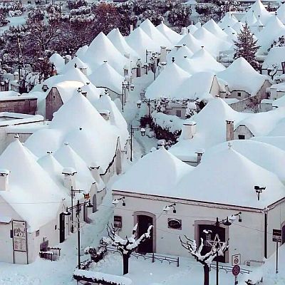
cold air irruptions from the Balkan peninsula, which can bring snowfall to the hills, and sometimes even at sea level. In fact, the cold air, originally dry, is charged with humidity as it passes over the Adriatic Sea. However, these cold spells are becoming rarer due to global warming.
In summer, on the other hand, Apulia can be affected by
heat waves from Africa, with peaks of 40 °C (104 °F) and more.
The coast
On the coast, the climate is
Mediterranean. Winters are mild and quite rainy, while summers are hot and sunny, with rare rainy days and some thunderstorms.

In
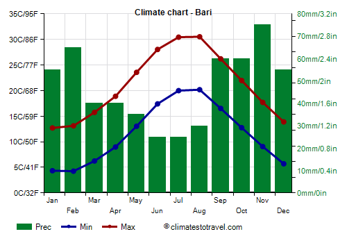
Bari, the capital, located on the coast, in the central part, the average temperature ranges from 8.5 °C (47 °F) in January to 25.5 °C (78 °F) in August. Voici les températures moyennes.
Bari - Average temperatures (1991-2020) |
| Month | Min | Max | Mean |
|---|
| January | 4.4 | 12.7 | 8.5 |
|---|
| February | 4.3 | 13.1 | 8.7 |
|---|
| March | 6.2 | 15.8 | 11 |
|---|
| April | 9 | 18.9 | 13.9 |
|---|
| May | 13 | 23.6 | 18.3 |
|---|
| June | 17.4 | 28 | 22.7 |
|---|
| July | 20 | 30.4 | 25.2 |
|---|
| August | 20.2 | 30.5 | 25.4 |
|---|
| September | 16.5 | 26.2 | 21.4 |
|---|
| October | 12.8 | 22 | 17.4 |
|---|
| November | 9.1 | 17.7 | 13.4 |
|---|
| December | 5.7 | 13.9 | 9.8 |
|---|
| Year | 11.6 | 21.1 | 16.3 |
|---|
Precipitation amounts to 565 mm (22 in) per year. Here is the average precipitation.
Bari - Average precipitation| Month | Days |
|---|
| January | 55 | 7 |
|---|
| February | 65 | 8 |
|---|
| March | 40 | 7 |
|---|
| April | 40 | 6 |
|---|
| May | 35 | 5 |
|---|
| June | 25 | 4 |
|---|
| July | 25 | 3 |
|---|
| August | 30 | 4 |
|---|
| September | 60 | 5 |
|---|
| October | 60 | 6 |
|---|
| November | 75 | 8 |
|---|
| December | 55 | 7 |
|---|
| Year | 565 | 70 |
|---|
In the southeast, the
Salento peninsula, facing the Adriatic Sea and the Ionian Sea (Gulf of Taranto), has a particularly mild but also windy climate.
On the seas around Apulia there are some small
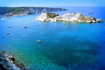
islands: in the Adriatic Sea we find the Tremiti islands, while in the Ionian Sea we find the small Cheradi islands near Taranto, and the island of Sant'Andrea near Gallipoli.

On the Apulian coasts, the
sea is warm enough for swimming from July to September, while it is still a little cool in June.
Here is the average sea temperature in Bari.
Bari - Sea temperature| Month |
|---|
| January | 14 |
|---|
| February | 14 |
|---|
| March | 14 |
|---|
| April | 15 |
|---|
| May | 18 |
|---|
| June | 22 |
|---|
| July | 25 |
|---|
| August | 26 |
|---|
| September | 23.5 |
|---|
| October | 20.5 |
|---|
| November | 17.5"> |
|---|
| December | 15.5 |
|---|
| Year | 18.8 |
|---|
Inland areas
In inland areas, in the northern plain, the climate is still Mediterranean, but takes on slightly continental characteristics, given that summer is very hot, while in winter, it can get cold at night and fog can form. Also, the rains are quite scarce.
Here are the average temperatures in
Foggia.
Foggia - Average temperatures (1991-2020) |
| Month | Min | Max | Mean |
|---|
| January | 3.4 | 12 | 7.7 |
|---|
| February | 3.1 | 13 | 8.1 |
|---|
| March | 5 | 15.8 | 10.4 |
|---|
| April | 7.3 | 19 | 13.1 |
|---|
| May | 11.9 | 25.2 | 18.6 |
|---|
| June | 16.3 | 30 | 23.1 |
|---|
| July | 18.7 | 32.6 | 25.7 |
|---|
| August | 19.4 | 33.1 | 26.2 |
|---|
| September | 15.6 | 27.6 | 21.6 |
|---|
| October | 12 | 23 | 17.5 |
|---|
| November | 8 | 16.9 | 12.4 |
|---|
| December | 4.8 | 12.8 | 8.8 |
|---|
| Year | 10.5 | 21.8 | 16.1 |
|---|
During outbreaks of cold air, the internal areas of Puglia are more exposed to snowfall than the coasts.

As the altitude increases, the climate becomes
moderately continental at hill altitudes, in the Murge plateau (see Alberobello, Altamura, Castel del Monte, Gioia del Colle), or
temperate above 700 meters (2,300 ft).
In the north-west, on the border with Campania, we find the
Subappennino Dauno (Daunian Mountains), which houses the highest peak in the region, Monte Cornacchia, at 1,151 metres (3,775 feet). To the north we find the promontory of
Gargano, protected in a national park, whose highest peak is 1,055 meters (3,461 ft).

In
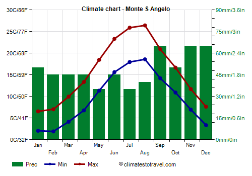
Monte Sant'Angelo, on the Gargano promontory, at an altitude of 800 metres (2,600 feet), the average temperature ranges from 4.5 °C (40 °F) in January and February to 22.5 °C (72.5 °F) in August. Here are the average temperatures.
Monte S Angelo - Average temperatures (1991-2020) |
| Month | Min | Max | Mean |
|---|
| January | 2.1 | 6.6 | 4.3 |
|---|
| February | 1.9 | 7 | 4.5 |
|---|
| March | 4.2 | 10 | 7.1 |
|---|
| April | 6.8 | 13.4 | 10.1 |
|---|
| May | 11.4 | 18.5 | 14.9 |
|---|
| June | 15.6 | 23.3 | 19.5 |
|---|
| July | 18 | 25.9 | 22 |
|---|
| August | 18.6 | 26.4 | 22.5 |
|---|
| September | 14.2 | 20.9 | 17.6 |
|---|
| October | 10.9 | 16.7 | 13.8 |
|---|
| November | 7 | 11.7 | 9.3 |
|---|
| December | 3.4 | 7.6 | 5.5 |
|---|
| Year | 9.5 | 15.7 | 12.6 |
|---|
Precipitation amounts to 585 mm (23 in) per year.
Monte S Angelo - Average precipitation| Month | Days |
|---|
| January | 50 | 7 |
|---|
| February | 45 | 7 |
|---|
| March | 45 | 7 |
|---|
| April | 45 | 7 |
|---|
| May | 35 | 5 |
|---|
| June | 45 | 5 |
|---|
| July | 35 | 4 |
|---|
| August | 40 | 5 |
|---|
| September | 65 | 6 |
|---|
| October | 50 | 6 |
|---|
| November | 65 | 8 |
|---|
| December | 65 | 8 |
|---|
| Year | 585 | 75 |
|---|
Best Time
The best months for a
beach holiday in Apulia are July and August. In June, the days are long and the weather is often good, but the sea is still a bit cool. You can still go in September, in fact the sea is still quite warm, but the days get shorter and the first waves of bad weather can occur, especially in the second half of the month.
To
visit the cities, you can choose the periods from mid-April to mid-May and from mid-September to mid-October, since in summer it can get very hot. It must be said that in both periods there may be rainy days.
See also the
temperatures by month.