Select units of measurement for the temperature and rainfall tables (metric or imperial).
Average weather, temperature, rainfall, sunshine
In Slovakia, a small country located in Eastern Europe between 47 and 49 degrees north latitude, the climate is
moderately continental in the plains, while it becomes colder with increasing altitude in mountainous areas.
The west (see Bratislava, Nitra) is flat, in the north, there's the vast region occupied by the
Tatra Mountains, while the rest of the country is covered with hills and low mountains, which belong (like the same Tatras) to the vast region of the Carpathians.
Precipitation (rain and snow) is not abundant at low altitudes, in fact it amounts to 600/650 millimeters (23/25 in) per year, while it is more abundant in the high mountains. Generally, the rainiest period goes from May to August, also due to afternoon thunderstorms.
The climate in detail
Plains
In the
western part of Slovakia, where Bratislava is located, the climate is moderately continental, with cold winters and warm summers. Precipitation is fairly frequent throughout the year, but it's most abundant in late spring and summer, when it can occur in the form of thunderstorm, while in winter, it often takes place in the form of light snow.
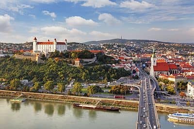
Bratislava
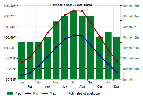
In
Bratislava, the capital, the daily average temperatures in winter are around freezing (0 °C or 32 °F), while in July and August, they are around 16 °C (61 °F) at night and 27/28 °C (81/82 °F) during the day.
During winter, the weather is often gray and damp, however, there can also be intense frosts during outbreaks of cold air from Russia, when the temperature can drop to -20 °C (-4 °F).
In summer, there can sometimes be hot and muggy days, when southern air masses prevail, with peaks of 35 °C (95 °F).
In Bratislava, precipitation amounts to 580 mm (22.8 in) per year, so it is not abundant, but it is well distributed over the seasons.
In Bratislava, the sun is rarely seen from November to January, while from May to August, it shines for a little more than half the time (compared to the length of the days).
Kosice
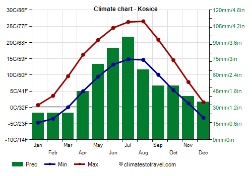
In the valleys and plains of the
central-eastern area, the climate takes on the continental characteristics which are typical of Eastern Europe. Winters are colder than in the capital, with longer periods below freezing even during the day and weak but frequent snowfalls. Summers are warm, with frequent sunshine but also fairly frequent afternoon thunderstorms.
In
Košice, the average temperature ranges from around -2 °C (28.5 °F) in January to 20.5 °C (69 °F) in July and August.
Precipitation amounts to 610 mm (24 in) per year.
Hills and mountains
Most places throughout the central and eastern part of the country are located at a few hundred meters of altitude, which is enough to make the climate slightly colder than in Bratislava, in fact, snow remains on the ground more easily during winter, while summer is generally cool, and the heat, when present, is more bearable.
Poprad
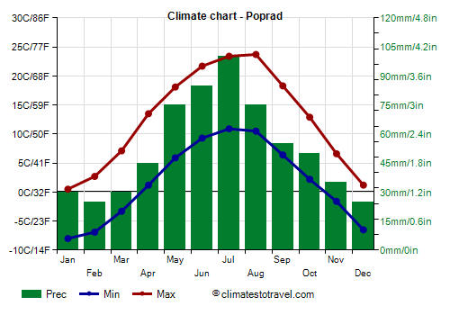
In
Poprad, located at 700 meters (2,300 feet) above sea level, the average temperature ranges from -2 °C (28.5 °F) in January to 20.5 °C (69 °F) in July and August.
Precipitation amounts to 635 mm (25 in) per year.
The
mountainous areas of Slovakia have a colder climate because of the altitude, especially the northern part, where the
Tatra Mountains are located. Here, the climate is freezing and snowy in winter, while afternoon thunderstorms are quite frequent in summer. Moreover, the wind is more frequent. At 2,000 meters (6,500 feet) above sea level, the average temperature is around -8 °C (18 °F) in January and around 6/7 °C (43/45 °F) in July.
Lomnicky stit
On the top of the
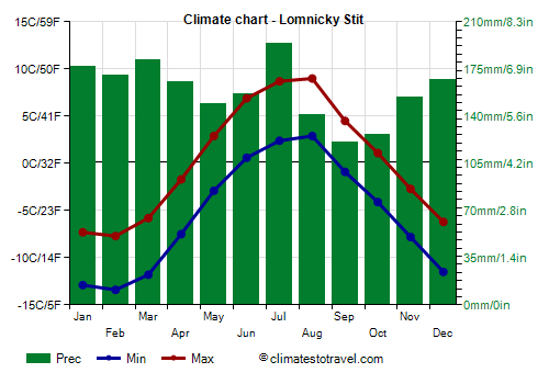
Peak Lomnický, at 2,634 meters (8,642 feet) of altitude, the averages for January and February are below -10 °C (14 °F). Furthermore, it's cold and it can snow even in summer.
When to go
The best time to visit Slovakia runs from
mid-May to mid-September.
In July and August, hot and muggy days may occur, especially in the lowlands (the region of Bratislava and the easternmost plain), while in the rest of the country, nights remain cool even in the hottest periods.
In plains and valleys, during the warmest months, the rains occur often in the form of short thunderstorms, which do not reduce too much the hours of sunshine, while in the mountains, cloudiness in the afternoon is more frequent.
What to pack
In
winter: bring warm clothes, such as a sweater, a down jacket, a hat, gloves, and a scarf.
In
summer: bring light clothes, a T-shirt and shorts, but also long pants, a jacket and a sweater for the evening or for cooler days; a raincoat or umbrella. For the mountains, bring warmer clothes depending on altitude, hiking shoes and sunglasses.
Climate data - Slovakia
| Banska Bystrica (315 meters) |
|---|
|
| Jan | Feb | Mar | Apr | May | Jun | Jul | Aug | Sep | Oct | Nov | Dec |
|---|
| Min temp. | -6 | -5 | -1 | 3 | 8 | 12 | 13 | 13 | 8 | 4 | 1 | -4 |
|---|
| Max temp. | 1 | 5 | 10 | 17 | 22 | 25 | 27 | 27 | 21 | 15 | 8 | 2 |
|---|
| Precip. | 45 | 40 | 45 | 45 | 70 | 80 | 90 | 65 | 55 | 65 | 60 | 50 |
|---|
| Prec. days | 8 | 7 | 7 | 7 | 10 | 9 | 10 | 7 | 7 | 8 | 9 | 8 |
|---|
|
|
| Sun hours | 2 | 3 | 5 | 7 | 8 | 8 | 9 | 8 | 6 | 4 | 2 | 2 |
|---|
|
| Bratislava |
|---|
|
| Jan | Feb | Mar | Apr | May | Jun | Jul | Aug | Sep | Oct | Nov | Dec |
|---|
| Min temp. | -3 | -2 | 2 | 6 | 10 | 14 | 16 | 16 | 11 | 6 | 2 | -2 |
|---|
| Max temp. | 3 | 6 | 11 | 17 | 22 | 25 | 28 | 27 | 22 | 15 | 9 | 4 |
|---|
| Precip. | 35 | 35 | 35 | 40 | 55 | 60 | 65 | 60 | 60 | 40 | 45 | 40 |
|---|
| Prec. days | 8 | 7 | 7 | 6 | 8 | 8 | 8 | 7 | 7 | 6 | 8 | 8 |
|---|
| Humidity | 81% | 75% | 67% | 60% | 63% | 62% | 60% | 62% | 69% | 77% | 82% | 84% |
|---|
| Day length | 9 | 10 | 12 | 14 | 15 | 16 | 16 | 14 | 12 | 11 | 9 | 8 |
|---|
| Sun hours | 2 | 4 | 5 | 7 | 8 | 9 | 9 | 9 | 6 | 4 | 2 | 2 |
|---|
|
| Chopok (1,995 meters) |
|---|
|
| Jan | Feb | Mar | Apr | May | Jun | Jul | Aug | Sep | Oct | Nov | Dec |
|---|
| Min temp. | -10 | -11 | -9 | -4 | 1 | 4 | 6 | 6 | 2 | -2 | -6 | -9 |
|---|
| Max temp. | -5 | -5 | -3 | 1 | 6 | 10 | 12 | 12 | 7 | 3 | -1 | -4 |
|---|
| Precip. | 80 | 85 | 95 | 80 | 115 | 135 | 155 | 110 | 95 | 85 | 75 | 85 |
|---|
| Prec. days | 14 | 13 | 14 | 13 | 15 | 15 | 15 | 11 | 12 | 12 | 13 | 14 |
|---|
|
|
| Sun hours | 3 | 3 | 4 | 5 | 5 | 5 | 6 | 6 | 4 | 3 | 3 | 3 |
|---|
|
| Hurbanovo |
|---|
|
| Jan | Feb | Mar | Apr | May | Jun | Jul | Aug | Sep | Oct | Nov | Dec |
|---|
| Min temp. | -3 | -2 | 1 | 6 | 10 | 14 | 16 | 15 | 11 | 6 | 3 | -2 |
|---|
| Max temp. | 3 | 6 | 12 | 18 | 23 | 26 | 28 | 28 | 23 | 17 | 10 | 4 |
|---|
| Precip. | 35 | 30 | 35 | 30 | 60 | 60 | 70 | 55 | 55 | 45 | 50 | 40 |
|---|
| Prec. days | 7 | 6 | 6 | 5 | 9 | 8 | 7 | 6 | 6 | 7 | 8 | 7 |
|---|
|
|
| Sun hours | 2 | 4 | 5 | 7 | 8 | 9 | 9 | 9 | 6 | 4 | 3 | 2 |
|---|
|
| Kosice (200 meters) |
|---|
|
| Jan | Feb | Mar | Apr | May | Jun | Jul | Aug | Sep | Oct | Nov | Dec |
|---|
| Min temp. | -5 | -4 | 0 | 5 | 9 | 13 | 15 | 15 | 10 | 5 | 1 | -3 |
|---|
| Max temp. | 1 | 4 | 10 | 16 | 21 | 24 | 26 | 27 | 21 | 15 | 8 | 2 |
|---|
| Precip. | 25 | 25 | 25 | 45 | 70 | 85 | 95 | 65 | 50 | 50 | 40 | 35 |
|---|
| Prec. days | 6 | 6 | 5 | 7 | 10 | 10 | 10 | 7 | 7 | 7 | 7 | 7 |
|---|
| Humidity | 85% | 79% | 68% | 62% | 66% | 67% | 67% | 66% | 71% | 78% | 85% | 87% |
|---|
| Day length | 9 | 10 | 12 | 14 | 15 | 16 | 16 | 14 | 12 | 11 | 9 | 8 |
|---|
| Sun hours | 2 | 3 | 5 | 7 | 8 | 8 | 8 | 8 | 6 | 4 | 2 | 1 |
|---|
|
| Lomnicky Stit (2,634 meters) |
|---|
|
| Jan | Feb | Mar | Apr | May | Jun | Jul | Aug | Sep | Oct | Nov | Dec |
|---|
| Min temp. | -13 | -13 | -12 | -8 | -3 | 1 | 2 | 3 | -1 | -4 | -8 | -12 |
|---|
| Max temp. | -7 | -8 | -6 | -2 | 3 | 7 | 9 | 9 | 4 | 1 | -3 | -6 |
|---|
| Precip. | 175 | 170 | 180 | 165 | 150 | 155 | 195 | 140 | 120 | 125 | 155 | 165 |
|---|
| Prec. days | 16 | 16 | 17 | 16 | 16 | 16 | 17 | 13 | 12 | 13 | 14 | 17 |
|---|
|
|
| Sun hours | 4 | 5 | 5 | 6 | 5 | 5 | 5 | 6 | 6 | 5 | 4 | 4 |
|---|
|
| Lucenec (215 meters) |
|---|
|
| Jan | Feb | Mar | Apr | May | Jun | Jul | Aug | Sep | Oct | Nov | Dec |
|---|
| Min temp. | -5 | -4 | 0 | 4 | 9 | 12 | 14 | 14 | 10 | 5 | 1 | -4 |
|---|
| Max temp. | 2 | 5 | 11 | 18 | 22 | 26 | 28 | 28 | 22 | 16 | 8 | 2 |
|---|
| Precip. | 30 | 30 | 30 | 40 | 70 | 75 | 90 | 65 | 50 | 50 | 45 | 35 |
|---|
| Prec. days | 6 | 6 | 6 | 6 | 10 | 9 | 8 | 7 | 6 | 7 | 8 | 7 |
|---|
|
|
| Sun hours | 2 | 3 | 5 | 7 | 8 | 9 | 9 | 9 | 6 | 4 | 2 | 2 |
|---|
|
| Nitra |
|---|
|
| Jan | Feb | Mar | Apr | May | Jun | Jul | Aug | Sep | Oct | Nov | Dec |
|---|
| Min temp. | -4 | -3 | 1 | 5 | 10 | 13 | 15 | 15 | 10 | 6 | 2 | -2 |
|---|
| Max temp. | 3 | 5 | 11 | 18 | 22 | 26 | 28 | 28 | 22 | 16 | 9 | 3 |
|---|
| Precip. | 35 | 30 | 35 | 35 | 60 | 60 | 65 | 55 | 60 | 45 | 45 | 40 |
|---|
| Prec. days | 7 | 6 | 6 | 6 | 8 | 7 | 7 | 6 | 6 | 6 | 8 | 7 |
|---|
|
|
| Sun hours | 2 | 4 | 5 | 7 | 8 | 9 | 9 | 9 | 7 | 5 | 2 | 2 |
|---|
|
| Poprad (700 meters) |
|---|
|
| Jan | Feb | Mar | Apr | May | Jun | Jul | Aug | Sep | Oct | Nov | Dec |
|---|
| Min temp. | -8 | -7 | -3 | 1 | 6 | 9 | 11 | 10 | 6 | 2 | -2 | -6 |
|---|
| Max temp. | 0 | 3 | 7 | 14 | 18 | 22 | 23 | 24 | 18 | 13 | 7 | 1 |
|---|
| Precip. | 30 | 25 | 30 | 45 | 75 | 85 | 100 | 75 | 55 | 50 | 35 | 25 |
|---|
| Prec. days | 6 | 6 | 7 | 8 | 10 | 10 | 11 | 8 | 8 | 7 | 7 | 6 |
|---|
| Humidity | 81% | 77% | 71% | 66% | 69% | 71% | 71% | 71% | 75% | 78% | 83% | 84% |
|---|
| Day length | 9 | 10 | 12 | 14 | 15 | 16 | 16 | 14 | 12 | 11 | 9 | 8 |
|---|
| Sun hours | 3 | 4 | 5 | 6 | 7 | 8 | 8 | 8 | 6 | 5 | 3 | 2 |
|---|
|
| Presov (250 meters) |
|---|
|
| Jan | Feb | Mar | Apr | May | Jun | Jul | Aug | Sep | Oct | Nov | Dec |
|---|
| Min temp. | -6 | -5 | -1 | 3 | 8 | 12 | 13 | 13 | 9 | 4 | 0 | -4 |
|---|
| Max temp. | 0 | 3 | 9 | 16 | 20 | 24 | 26 | 26 | 20 | 14 | 7 | 1 |
|---|
| Precip. | 20 | 25 | 25 | 45 | 85 | 95 | 110 | 75 | 55 | 55 | 35 | 25 |
|---|
| Prec. days | 6 | 6 | 5 | 8 | 11 | 10 | 12 | 8 | 8 | 8 | 6 | 6 |
|---|
|
|
| Sun hours | 1 | 2 | 4 | 6 | 7 | 7 | 8 | 8 | 6 | 4 | 2 | 1 |
|---|
|
| Stropkov (215 meters) |
|---|
|
| Jan | Feb | Mar | Apr | May | Jun | Jul | Aug | Sep | Oct | Nov | Dec |
|---|
| Min temp. | -5 | -4 | -1 | 3 | 8 | 12 | 13 | 13 | 9 | 5 | 1 | -3 |
|---|
| Max temp. | 1 | 3 | 9 | 16 | 21 | 24 | 26 | 26 | 20 | 14 | 8 | 2 |
|---|
| Precip. | 35 | 35 | 35 | 45 | 80 | 90 | 105 | 75 | 60 | 55 | 40 | 40 |
|---|
| Prec. days | 9 | 8 | 7 | 8 | 11 | 10 | 11 | 8 | 8 | 8 | 8 | 9 |
|---|
|
|
| Sun hours | 2 | 3 | 4 | 6 | 7 | 8 | 8 | 8 | 6 | 4 | 2 | 1 |
|---|
|
| Zilina (310 meters) |
|---|
|
| Jan | Feb | Mar | Apr | May | Jun | Jul | Aug | Sep | Oct | Nov | Dec |
|---|
| Min temp. | -5 | -4 | -1 | 3 | 8 | 11 | 13 | 13 | 9 | 5 | 1 | -4 |
|---|
| Max temp. | 1 | 4 | 9 | 16 | 20 | 24 | 26 | 26 | 20 | 15 | 8 | 2 |
|---|
| Precip. | 45 | 40 | 45 | 45 | 75 | 85 | 95 | 80 | 70 | 65 | 50 | 50 |
|---|
| Prec. days | 10 | 8 | 8 | 8 | 10 | 10 | 11 | 9 | 9 | 9 | 8 | 10 |
|---|
|
|
| Sun hours | 2 | 3 | 4 | 6 | 7 | 8 | 8 | 8 | 5 | 3 | 2 | 1 |
|---|
|
See also the
temperatures month by month