Select units of measurement for the temperature and rainfall tables (metric or imperial).
Average weather, temperature, rainfall, sunshine
The climate in the Czech Republic (or Czechia) is
moderately continental, with cold winters, during which the temperature is often below freezing, and warm summers, during which nights remain cool.
Precipitation (rain or snow) is fairly frequent, but it's not abundant in most of the country, amounting to around 400/500 millimeters (15/20 inches) per year. However, being scarcer in the winter months (when plants are at rest) and more abundant in late spring and summer, it is generally sufficient for agriculture.
The only moderately rainy areas are found in the Sudetes Range, where precipitation exceeds 1,000 mm (40 in) per year, at the foot of the same mountain range (in Ostrava, precipitation reaches 850 mm or 33.5 inches per year), and in the south-west, along the border with Germany and Austria.
The Czech Republic is a small country without access to the sea, located in central-eastern Europe, between 48 and 51 degrees north latitude.
The climate in detail
The seasons
During
winter, from December to February, in Prague and in the other Czech cities, temperatures hover around freezing (0 °C or 32 °F) or just below, the weather is often dull and cloudy, and light snowfalls can occur.
On the contrary,
outbreaks of cold air can bring intense frosts, with temperatures dropping to -20/-25 °C (-4/-13 °F) in the worst moments.
In
spring, from March to May, the weather is unstable, and the first warm days alternate with the return of cold weather. Frosts and snowfalls can still occur in April, especially in the first part of the month.
There is usually a turning point in the second half of May, when the maximum temperatures regularly reach or exceed 18/20 °C (64/68 °F), and the weather becomes enjoyable.
Summer, from June to August, is usually warm. On average, highs are 24/26 °C (75/79 °F) in July and August.
There is a moderate amount of sunny days, during which showers or thunderstorms can erupt in the afternoon.
Even in mid-summer, there can be cool and rainy days, with highs around 20 °C (68 °F).
However, there can also be
very hot periods, in which the temperature reaches or exceeds 35 °C (95 °F).
Autumn, which goes from September to November, is initially pleasant in the first half of September, and then becomes progressively more cloudy and cold, with fairly frequent rains.
Plains and hills
Most of the country is located between 200 and 500 meters (600 and 1,600 feet) above sea level, and has a fairly homogeneous climate.
Prague

In the capital,
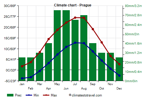
Prague, the altitude varies between 180 and 400 meters (600 and 1,300 feet). At the airport, the average temperature ranges from -1 °C (30 °F) in January to 18.5 °C (65 °F) in July and August.
In Prague, 500 mm (20 in) of rain or snow fall per year. Since the amount of precipitation falling during winter is not high,
snowfalls are frequent but generally not abundant.
During the
summer, instead, the rains take place in the form of afternoon thunderstorms on sunny days, or are brought by Atlantic weather fronts, which can arrive even in this season.
In Prague, the
sun is rarely seen from November to February, while in summer, the sun can be obscured by Atlantic disturbances as well as by cloudiness in the afternoon, which, as we said, can also lead to thunderstorms.
On average, there are 1,740 hours of sunshine per year, slightly more than in London and Paris.
Mountains
In the north, in the
Sudetes mountainous area, on the border with Poland, the weather cools down with altitude, especially in summer: at 800 meters (2,600 feet) above sea level, summer is cool, and the daytime temperature is typically around 18 °C (64 °F).
Sniezka

The highest point in the Czech Republic is Mount
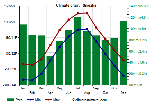
Snežka, 1,603 meters (5,259 feet) high. Here, the average temperature ranges from around -6 °C (21 °F) in January to around 10 °C (50 °F) in July and August.
Precipitation amounts to almost 1,100 mm (43 in) per year.

When to go
The best time to visit the Czech Republic runs from
mid-May to mid-September, since it is the warmest, or at least the mildest, of the year. Temperatures can be cool in May and September, and sometimes in June, while they are normally higher in mid-summer (July and August).
What to pack
In
winter: bring warm clothes, such as a sweater, a down jacket, a hat, gloves, and a scarf.
In
summer: bring light clothes, t-shirts and shorts, but also long pants, a jacket and a sweatshirt for the evening or for cooler days, and a raincoat or umbrella.
Climate data - Czech Republic
| Brno (240 meters) |
|---|
|
| Jan | Feb | Mar | Apr | May | Jun | Jul | Aug | Sep | Oct | Nov | Dec |
|---|
| Min temp. | -4 | -2 | 1 | 5 | 10 | 13 | 15 | 15 | 11 | 6 | 2 | -2 |
|---|
| Max temp. | 2 | 4 | 10 | 16 | 20 | 24 | 26 | 26 | 20 | 14 | 8 | 3 |
|---|
| Precip. | 25 | 20 | 30 | 25 | 60 | 70 | 70 | 60 | 50 | 35 | 30 | 30 |
|---|
| Prec. days | 6 | 5 | 6 | 6 | 9 | 8 | 10 | 7 | 6 | 6 | 7 | 7 |
|---|
| Humidity | 85% | 79% | 70% | 62% | 65% | 66% | 64% | 64% | 71% | 79% | 85% | 87% |
|---|
| Day length | 9 | 10 | 12 | 14 | 15 | 16 | 16 | 14 | 12 | 11 | 9 | 8 |
|---|
| Sun hours | 2 | 3 | 4 | 7 | 8 | 8 | 8 | 8 | 6 | 4 | 2 | 1 |
|---|
|
| Ceske Budejovice (415 meters) |
|---|
|
| Jan | Feb | Mar | Apr | May | Jun | Jul | Aug | Sep | Oct | Nov | Dec |
|---|
| Min temp. | -4 | -3 | 0 | 4 | 8 | 12 | 13 | 13 | 9 | 5 | 1 | -2 |
|---|
| Max temp. | 3 | 5 | 10 | 16 | 20 | 24 | 26 | 26 | 20 | 14 | 8 | 4 |
|---|
| Precip. | 30 | 25 | 40 | 40 | 75 | 100 | 95 | 90 | 60 | 45 | 35 | 30 |
|---|
| Prec. days | 7 | 6 | 8 | 7 | 11 | 10 | 11 | 9 | 8 | 8 | 8 | 7 |
|---|
|
|
| Sun hours | 2 | 3 | 4 | 6 | 7 | 7 | 8 | 7 | 5 | 4 | 2 | 2 |
|---|
|
| Cheb (485 meters) |
|---|
|
| Jan | Feb | Mar | Apr | May | Jun | Jul | Aug | Sep | Oct | Nov | Dec |
|---|
| Min temp. | -4 | -3 | 0 | 3 | 7 | 10 | 12 | 12 | 8 | 5 | 1 | -2 |
|---|
| Max temp. | 2 | 4 | 8 | 14 | 19 | 22 | 24 | 24 | 19 | 13 | 6 | 2 |
|---|
| Precip. | 40 | 30 | 40 | 35 | 55 | 70 | 75 | 70 | 55 | 45 | 45 | 45 |
|---|
| Prec. days | 10 | 8 | 9 | 8 | 10 | 10 | 11 | 9 | 8 | 9 | 9 | 10 |
|---|
|
|
| Sun hours | 1 | 3 | 4 | 6 | 7 | 7 | 7 | 7 | 5 | 3 | 1 | 1 |
|---|
|
| Holesov (225 meters) |
|---|
|
| Jan | Feb | Mar | Apr | May | Jun | Jul | Aug | Sep | Oct | Nov | Dec |
|---|
| Min temp. | -4 | -4 | -1 | 3 | 8 | 12 | 13 | 13 | 10 | 5 | 2 | -3 |
|---|
| Max temp. | 2 | 4 | 9 | 16 | 20 | 24 | 26 | 26 | 20 | 14 | 8 | 3 |
|---|
| Precip. | 30 | 30 | 35 | 40 | 70 | 80 | 85 | 70 | 70 | 45 | 40 | 35 |
|---|
| Prec. days | 7 | 7 | 8 | 7 | 10 | 9 | 10 | 8 | 8 | 8 | 7 | 7 |
|---|
|
|
| Sun hours | 2 | 3 | 4 | 7 | 8 | 8 | 8 | 8 | 6 | 4 | 2 | 1 |
|---|
|
| Karlovy Vary (600 meters) |
|---|
|
| Jan | Feb | Mar | Apr | May | Jun | Jul | Aug | Sep | Oct | Nov | Dec |
|---|
| Min temp. | -5 | -4 | -2 | 2 | 6 | 9 | 11 | 11 | 7 | 3 | 0 | -4 |
|---|
| Max temp. | 1 | 2 | 7 | 13 | 17 | 21 | 23 | 22 | 17 | 11 | 5 | 1 |
|---|
| Precip. | 35 | 30 | 35 | 30 | 55 | 70 | 70 | 65 | 55 | 45 | 40 | 40 |
|---|
| Prec. days | 9 | 7 | 8 | 7 | 10 | 10 | 11 | 9 | 8 | 8 | 8 | 9 |
|---|
|
|
| Sun hours | 1 | 3 | 4 | 6 | 7 | 7 | 7 | 7 | 5 | 3 | 1 | 1 |
|---|
|
| Liberec (400 meters) |
|---|
|
| Jan | Feb | Mar | Apr | May | Jun | Jul | Aug | Sep | Oct | Nov | Dec |
|---|
| Min temp. | -4 | -4 | -1 | 3 | 7 | 10 | 12 | 12 | 8 | 5 | 1 | -2 |
|---|
| Max temp. | 1 | 3 | 7 | 14 | 18 | 21 | 24 | 24 | 18 | 12 | 6 | 2 |
|---|
| Precip. | 65 | 55 | 60 | 40 | 75 | 90 | 105 | 100 | 70 | 60 | 60 | 65 |
|---|
| Prec. days | 13 | 11 | 12 | 8 | 11 | 11 | 12 | 10 | 10 | 10 | 11 | 12 |
|---|
|
|
| Sun hours | 1 | 2 | 4 | 6 | 7 | 7 | 7 | 7 | 5 | 3 | 1 | 1 |
|---|
|
| Lysa Hora (1,320 meters) |
|---|
|
| Jan | Feb | Mar | Apr | May | Jun | Jul | Aug | Sep | Oct | Nov | Dec |
|---|
| Min temp. | -7 | -7 | -5 | 0 | 4 | 8 | 10 | 10 | 6 | 2 | -2 | -6 |
|---|
| Max temp. | -3 | -2 | 1 | 7 | 12 | 16 | 18 | 18 | 12 | 7 | 2 | -2 |
|---|
| Precip. | 90 | 90 | 95 | 95 | 150 | 165 | 200 | 140 | 145 | 105 | 95 | 100 |
|---|
| Prec. days | 13 | 13 | 13 | 11 | 14 | 13 | 14 | 11 | 11 | 11 | 12 | 14 |
|---|
|
|
| Sun hours | 2 | 3 | 4 | 5 | 6 | 6 | 7 | 7 | 5 | 3 | 2 | 2 |
|---|
|
| Ostrava (230 meters) |
|---|
|
| Jan | Feb | Mar | Apr | May | Jun | Jul | Aug | Sep | Oct | Nov | Dec |
|---|
| Min temp. | -4 | -3 | 0 | 4 | 8 | 12 | 14 | 14 | 9 | 6 | 2 | -2 |
|---|
| Max temp. | 2 | 4 | 8 | 15 | 20 | 23 | 25 | 25 | 20 | 14 | 8 | 3 |
|---|
| Precip. | 25 | 25 | 35 | 45 | 85 | 95 | 95 | 70 | 75 | 50 | 40 | 30 |
|---|
| Prec. days | 7 | 7 | 8 | 8 | 10 | 10 | 11 | 9 | 9 | 8 | 7 | 7 |
|---|
| Humidity | 85% | 81% | 74% | 67% | 71% | 72% | 70% | 70% | 76% | 81% | 84% | 85% |
|---|
| Day length | 9 | 10 | 12 | 14 | 16 | 16 | 16 | 14 | 12 | 11 | 9 | 8 |
|---|
| Sun hours | 2 | 3 | 4 | 6 | 7 | 7 | 8 | 8 | 5 | 4 | 2 | 1 |
|---|
|
| Pilsen (350 meters) |
|---|
|
| Jan | Feb | Mar | Apr | May | Jun | Jul | Aug | Sep | Oct | Nov | Dec |
|---|
| Min temp. | -2 | -2 | 0 | 4 | 8 | 12 | 14 | 13 | 10 | 6 | 2 | -1 |
|---|
| Max temp. | 3 | 5 | 10 | 17 | 20 | 24 | 26 | 26 | 21 | 14 | 7 | 4 |
|---|
| Precip. | 30 | 25 | 35 | 35 | 55 | 70 | 70 | 70 | 40 | 35 | 35 | 35 |
|---|
| Prec. days | 8 | 7 | 8 | 8 | 10 | 11 | 11 | 10 | 8 | 7 | 8 | 8 |
|---|
|
|
| Sun hours | 2 | 3 | 4 | 6 | 7 | 8 | 8 | 7 | 6 | 4 | 2 | 2 |
|---|
|
| Prague (360 meters) |
|---|
|
| Jan | Feb | Mar | Apr | May | Jun | Jul | Aug | Sep | Oct | Nov | Dec |
|---|
| Min temp. | -4 | -3 | 0 | 4 | 8 | 11 | 13 | 13 | 9 | 5 | 1 | -2 |
|---|
| Max temp. | 2 | 4 | 8 | 14 | 19 | 22 | 24 | 24 | 19 | 13 | 6 | 3 |
|---|
| Precip. | 20 | 20 | 30 | 30 | 60 | 75 | 80 | 65 | 40 | 35 | 30 | 25 |
|---|
| Prec. days | 6 | 6 | 7 | 6 | 9 | 10 | 10 | 9 | 7 | 7 | 7 | 6 |
|---|
| Humidity | 85% | 80% | 74% | 65% | 68% | 69% | 67% | 67% | 74% | 81% | 87% | 86% |
|---|
| Day length | 9 | 10 | 12 | 14 | 16 | 16 | 16 | 14 | 12 | 11 | 9 | 8 |
|---|
| Sun hours | 2 | 3 | 4 | 6 | 7 | 8 | 8 | 7 | 5 | 3 | 2 | 1 |
|---|
|
| Sniezka (1,600 meters) |
|---|
|
| Jan | Feb | Mar | Apr | May | Jun | Jul | Aug | Sep | Oct | Nov | Dec |
|---|
| Min temp. | -8 | -8 | -6 | -2 | 2 | 5 | 8 | 8 | 4 | 0 | -4 | -7 |
|---|
| Max temp. | -3 | -4 | -2 | 3 | 7 | 11 | 13 | 13 | 8 | 5 | 1 | -2 |
|---|
| Precip. | 105 | 90 | 90 | 50 | 80 | 100 | 120 | 95 | 85 | 80 | 85 | 115 |
|---|
| Prec. days | 17 | 14 | 15 | 10 | 13 | 13 | 14 | 11 | 12 | 13 | 14 | 16 |
|---|
|
|
|
|
See also the
temperatures month by month