Select units of measurement for the temperature and rainfall tables (metric or imperial).
Average weather, temperature, rainfall, sunshine
In Réunion, an overseas department of France located in the Indian Ocean south of the Equator, the climate is
tropical, with a hot, humid and rainy season from December to March and a cool season from June to September, ie the austral winter.
Generally, there is a
dry season from May to November, although this is not the case on the southeastern slope.
In fact, there are differences between the areas, especially in the rains. The
south-east trade winds blow all year round, but especially in the cool season, bringing rains to the eastern slopes.
In the interior of the island, which is
mountainous, the winds bring rainfall on the eastern slopes throughout the year, while the western slopes are rainy only in the hot and humid season, while in the rest of the year, they only receive a few rains and are even a bit warmer.
So, the island is basically
divided into two, and the northwest coast, where we also find the most beautiful beaches, is almost dry.
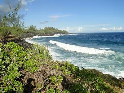
The
rains in Réunion occur in the form of short but intense showers, called
avalasses. As mentioned, in the interior, the elevations enhance the formation of thunderclouds on the slopes exposed to the wind, so much so that the rainfall can even reach 6 meters (235 inches) per year.
As regards to the coasts, the
eastern coast, where rainfall exceeds 3,000 millimeters (120 inches) per year, is much more rainy than the western one, from Le Port to Saint-Pierre, where it drops below 1,000 mm (40 in).
Along the coasts of Réunion, the amount of
sunshine is not excellent nor poor, since some cloudiness can form throughout the year, but as mentioned, the rains do not last long. On the contrary, on the slopes of the volcanoes, the sky is often cloudy.
The climate in detail
The coast
Saint-Denis
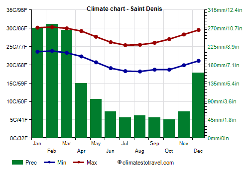
In the capital,
Saint-Denis, located on the north coast, daytime
temperatures from June to September drop to around 25/26 °C (77/79 °F) and night-time temperatures to around 18/19 °C (64/66 °F), but they can sometimes drop to 13/14 °C (55/57 °F). On the contrary, during the warmer period, from January to March, the temperature hovers around 30 °C (86 °F) during the day and around 23/24 °C (73/75 °F) at night.
As for the rains, on the north coast, we find an intermediate situation, with 1,530 mm (60 in) of rain falling per year. However, some showers may occur even in the driest months.
In Saint-Denis there are approximately 2,550 hours of sunshine per year.
In Réunion, the temperature of the
sea is high enough for swimming all year round, however, it decreases to 24/25 °C (75/77 °F) between July and October.
There are surfing spots, or diving can be done in the coral reef, even though there is the danger represented by currents and sharks.
Le Port
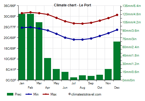
In
Le Port, on the north-west coast, the temperatures are slightly higher because the prevailing winds descend from the mountains.
The north-west coast, sheltered from the south-east trade winds, gets little rain. The rains in Le Port are very scarce from May to November, and in any case, they only total 540 mm (21.3 in) per year.
Inland areas
Cilaos
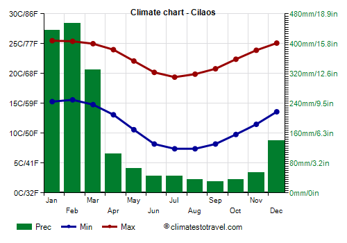
In the interior of the island, there is a town called
Cilaos, at 1,200 meters (3,900 feet) above sea level, inside the caldera of
Piton des Neiges volcano.
Temperatures are clearly lower than on the coasts due to the altitude.
In Cilaos, from 15 to 16 March 1952, as many as 1,870 mm (73.5 in) of rain fell, beating the world record of the highest 24-hour rainfall. However, in Cilaos, 1,765 mm (69.5 in) of rain fall per year on average, with a maximum of more than 300 mm (12 in) per month from January to March, and less than 100 mm (4 in) per month from May to November
 Piton des Neiges
 volcano is 3,069 meters (11,841 feet) high, but despite its name ("snowy peak"), it hardly ever sees snow even on the summit.
In the south-east of the island, there is another volcano,
Piton de la Fournaise, very active, 2,632 meters (8,635 feet) high.
Bellecombe
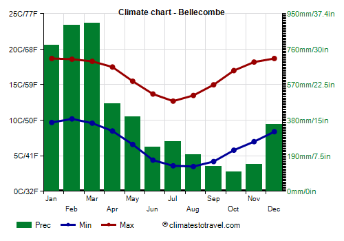
At
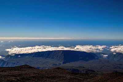
Bellecombe-Jacob Pass, located at 2,300 meters (7,500 feet), on the edge of the caldera of Piton de la Fournaise, the temperatures are mild in summer, while they are cold in winter.
Here, precipitation amounts to as high as 4,900 mm (192 in) per year. There is no real dry season, but the rains are a little less frequent and abundant from September to November.
Owing to the great amount of rain that falls in the interior, there are
forests as well as numerous streams (some of which are used for rafting), which give rise to waterfalls. The interior, with its spectacular landscape, is protected in a National Park since 2007, while in 2010, the island earned a place in the UNESCO World Heritage Site list.
Tropical cyclones
The island of Réunion is located in the path of
tropical cyclones, whose season runs from November 1 to May 15, although they are most common from late December to mid-April.
Some particularly intense cyclones that struck the island were Claudette in December 1979, Daniella in December 1996, Hollanda in February 1994, and Dina in January 2002. When Hurricane Dina affected the island, in La Plaine des Chicots (in the inland mountainous area), 2,102 mm (82.8 in) of rain fell in three days.
When to go
The best time to visit Réunion is the austral winter, ie
from mid-May to October, since it's the coolest and driest period of the year, and out of the hurricane season. However, during this period, the weather can be a bit cool for a beach holiday, also because of the trade winds, which blow especially along the eastern and southern coasts. You can then take advantage of the mild temperatures to explore the interior of the island (but remember that in winter, it is cold in the high mountains).
Alternatively, you can prefer
the second half of May and the month of October, which are slightly warmer, and in any case, you can choose the north-west coast, which is more sheltered from the wind.
Orchids bloom especially at the end of winter, ie between late September and October.
If you want to go in January and February, a period which in any case is not recommended because of the risk of cyclones, you can choose the west coast, from Le Port to Saint-Pierre, which is less rainy even during this period.
What to pack
In
winter (May to October): on the coast, bring light clothes, a sweatshirt or sweater, a light jacket, and a scarf for the breeze. In Cilaos, spring/autumn clothes, and a raincoat. When going mountain climbing, bring hiking boots, a fleece, a jacket, and a raincoat.
In
summer (December to arch): along the coast, bring tropics-friendly, loose-fitting clothing, light shirts and pants of natural fibers (cotton, linen), a light sweatshirt for the evening, and a light raincoat or umbrella. In Cilaos, bring light clothes, a sweatshirt or sweater, a light jacket, and a raincoat.
Climate data - Reunion
| Bellecombe (2,300 meters) |
|---|
|
| Jan | Feb | Mar | Apr | May | Jun | Jul | Aug | Sep | Oct | Nov | Dec |
|---|
| Min temp. | 10 | 10 | 10 | 8 | 7 | 4 | 4 | 4 | 4 | 6 | 7 | 8 |
|---|
| Max temp. | 19 | 19 | 18 | 18 | 16 | 14 | 13 | 14 | 15 | 17 | 18 | 19 |
|---|
| Precip. | 780 | 890 | 900 | 470 | 400 | 235 | 265 | 195 | 135 | 105 | 145 | 360 |
|---|
| Prec. days | 20 | 19 | 20 | 18 | 17 | 16 | 18 | 16 | 13 | 10 | 10 | 14 |
|---|
|
|
|
|
| Cilaos (1,200 meters) |
|---|
|
| Jan | Feb | Mar | Apr | May | Jun | Jul | Aug | Sep | Oct | Nov | Dec |
|---|
| Min temp. | 15 | 16 | 15 | 13 | 11 | 8 | 7 | 7 | 8 | 10 | 12 | 14 |
|---|
| Max temp. | 26 | 25 | 25 | 24 | 22 | 20 | 19 | 20 | 21 | 22 | 24 | 25 |
|---|
| Precip. | 435 | 455 | 330 | 105 | 65 | 45 | 45 | 35 | 30 | 35 | 55 | 140 |
|---|
| Prec. days | 13 | 13 | 11 | 9 | 6 | 6 | 6 | 4 | 4 | 4 | 5 | 9 |
|---|
|
|
| Sun hours | 5 | 5 | 5 | 5 | 6 | 6 | 6 | 6 | 6 | 6 | 6 | 5 |
|---|
|
| Le Port |
|---|
|
| Jan | Feb | Mar | Apr | May | Jun | Jul | Aug | Sep | Oct | Nov | Dec |
|---|
| Min temp. | 25 | 25 | 24 | 23 | 22 | 20 | 19 | 19 | 20 | 21 | 22 | 24 |
|---|
| Max temp. | 32 | 32 | 32 | 31 | 29 | 28 | 27 | 27 | 27 | 28 | 29 | 31 |
|---|
| Precip. | 120 | 120 | 105 | 40 | 20 | 15 | 5 | 10 | 10 | 10 | 20 | 70 |
|---|
| Prec. days | 8 | 7 | 6 | 3 | 3 | 1 | 1 | 1 | 1 | 1 | 2 | 5 |
|---|
| Humidity | 0% | 0% | 0% | 0% | 0% | 0% | 0% | 0% | 0% | 0% | 0% | 0% |
|---|
|
| Sun hours | 7 | 7 | 7 | 7 | 7 | 8 | 7 | 7 | 7 | 7 | 7 | 7 |
|---|
| Sea temp | 28 | 28 | 28 | 28 | 27 | 26 | 24 | 24 | 24 | 25 | 26 | 27 |
|---|
| Saint Denis |
|---|
|
| Jan | Feb | Mar | Apr | May | Jun | Jul | Aug | Sep | Oct | Nov | Dec |
|---|
| Min temp. | 24 | 24 | 23 | 22 | 21 | 19 | 18 | 18 | 19 | 19 | 20 | 21 |
|---|
| Max temp. | 30 | 30 | 30 | 29 | 28 | 26 | 25 | 25 | 26 | 27 | 28 | 30 |
|---|
| Precip. | 270 | 280 | 265 | 135 | 95 | 65 | 50 | 55 | 50 | 45 | 65 | 160 |
|---|
| Prec. days | 14 | 14 | 14 | 11 | 10 | 8 | 8 | 9 | 8 | 7 | 6 | 10 |
|---|
| Humidity | 76% | 77% | 76% | 74% | 72% | 69% | 69% | 68% | 68% | 69% | 70% | 73% |
|---|
| Day length | 13 | 13 | 12 | 12 | 11 | 11 | 11 | 11 | 12 | 13 | 13 | 13 |
|---|
| Sun hours | 7 | 7 | 7 | 7 | 7 | 7 | 7 | 7 | 7 | 7 | 7 | 7 |
|---|
| Sea temp | 28 | 28 | 28 | 28 | 27 | 26 | 24 | 24 | 24 | 25 | 26 | 27 |
|---|
See also the
temperatures month by month