Select units of measurement for the temperature and rainfall tables (metric or imperial).
Average weather, temperature, rainfall, sunshine hours
Calabria, the tip of the boot, is a region of southern Italy, facing the Tyrrhenian Sea to the west and the Ionian Sea to the east. To the south, the Strait of Messina separates it from Sicily. In the interior, Calabria is crossed by mountain ranges belonging to the southern Apennines, which often drop straight into the sea, while there are few plains.
The climate is
Mediterranean on the coasts, and colder in the mountain areas.
Precipitation is abundant in the mountains, where is exceeds 1,500 millimeters (59 inches) per year, it is relatively abundant in the cities at the foot of the mountains (see Catanzaro, Cosenza), where it amounts to about 1,000 mm (40 in) per year, while it drops below 600 mm (23.5 in) per year in the east, on the coast of the Gulf of Taranto (see Sibari) and in the extreme south (see Reggio Calabria).
Plains and hills
On the coasts and in the plains located nearby, the climate is
Mediterranean, with mild, rainy winters, and hot, sunny summers.

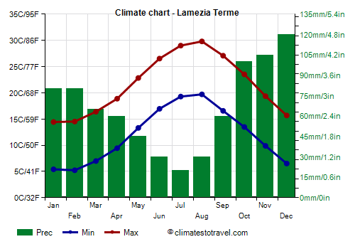
The average temperature in January and February ranges from 9.5/10 °C (49/50 °F) in the centre-north (see Lamezia Terme,
Crotone) to 12 °C (53.5 °F) in the southernmost part (see
Reggio Calabria). The average for July and August ranges from 25/26 °C (77/79 °F) in the north to 27/28 °C (80.5/82.5 °F) in the south.
Here is the average temperature of
Lamezia Terme airport, located near the west coast.
Lamezia Terme - Average temperatures (1991-2020) |
| Month | Min | Max | Mean |
|---|
| January | 5.4 | 14.4 | 9.9 |
|---|
| February | 5.2 | 14.5 | 9.9 |
|---|
| March | 7 | 16.4 | 11.7 |
|---|
| April | 9.4 | 18.9 | 14.2 |
|---|
| May | 13.3 | 22.8 | 18.1 |
|---|
| June | 17 | 26.5 | 21.7 |
|---|
| July | 19.3 | 29 | 24.2 |
|---|
| August | 19.7 | 29.8 | 24.8 |
|---|
| September | 16.6 | 27.1 | 21.8 |
|---|
| October | 13.5 | 23.5 | 18.5 |
|---|
| November | 9.9 | 19.4 | 14.6 |
|---|
| December | 6.5 | 15.7 | 11.1 |
|---|
| Year | 11.9 | 21.5 | 16.7 |
|---|
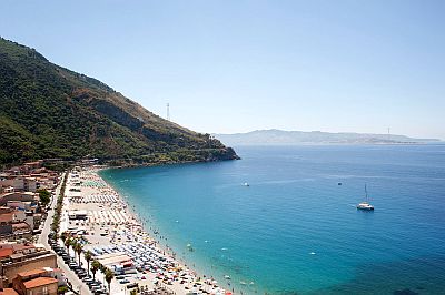
On both coasts of Calabria, the
sea is warm enough for swimming from July to September, while it is a little cool in June and October.
Here is the average sea temperature in Lamezia Terme.
Lamezia Terme - Sea temperature| Month |
|---|
| January | 15 |
|---|
| February | 14.5 |
|---|
| March | 14.5 |
|---|
| April | 16 |
|---|
| May | 18.5 |
|---|
| June | 22.5 |
|---|
| July | 25.5 |
|---|
| August | 26.5 |
|---|
| September | 25.5 |
|---|
| October | 22.5 |
|---|
| November | 19.5"> |
|---|
| December | 16.5 |
|---|
| Year | 19.8 |
|---|

On the eastern coast, especially in the northern part, facing the Gulf of Taranto (see Sibari, Cirò Marina), more exposed to cold winds from Eastern Europe, in winter, there can sometimes be
cold and windy periods, generally of short duration, with highs of around 5 °C (41 °F), and during which there may even be a light snowfall or rain mixed with snow. However, to see the beaches covered with snow, you have to wait several years.
In the rest of the region,
snow is very rare, at least along the coasts, while in the hill areas, especially in the valleys closed between the mountains (see Cosenza), it can sometimes snow.
On the coast of the Ionian Sea, occasionally the temperature can drop slightly below freezing, while this almost never happens on the Tyrrhenian coast, and never in the extreme south (see Reggio Calabria).
In summer, from June to August, in the lowlands of Calabria there can be
heat waves of African origin, during which the temperature can reach, and sometimes exceed, 40 °C (104 °F).
Mountains
In
mountainous areas, the climate naturally becomes colder. Fog often forms, especially in winter. In the mountains of Calabria, abundant snowfalls can occur in winter, and above 1,500 meters (5,00 feet), during the most intense bad weather waves, as high as 2-3 meters (6-10 feet) of snow can fall. In summer, on the other hand, thunderstorms can break out in the afternoon. Given the proximity to the coasts, thunderstorms can sometimes reach the latter.
The highest peak in the region is located in the north, on the border with Basilicata, in the
Pollino Massif (protected in a national park), and reaches 2,248 meters (7,375 ft) in height.
Further south, in the north-central part, we find the
Coastal chain to the west and, to the east of the Crati valley (where
Cosenza is located), the mountain massif of the
Sila, which reaches 1,928 meters (6,325 ft) in Mount Botte Donato.

In
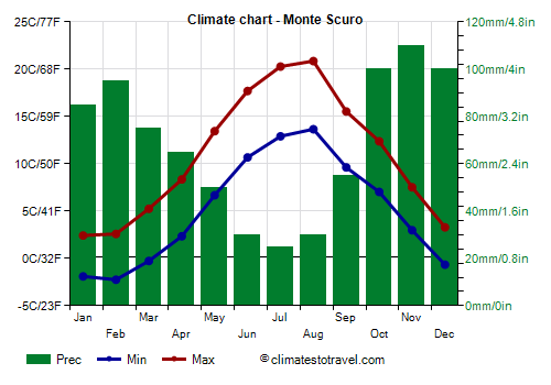
Monte Scuro, located at 1,670 meters (5,480 ft) on the Sila, west of Camigliatello Silano, the average temperature is around the freezing mark in January and February, while it reaches around 17 °C (62.5 °F) in July and August. Precipitation amounts to 815 mm (32 in) per year, with a maximum from October to December and a minimum in summer.
During the most intense cold spells, the temperature can drop to -13/-14 °C (7/9 °F) from December to March, while with the sirocco from Africa it has even reached 28/29 °C (82/84 °F) from June to August.
Monte Scuro - Average temperatures (1991-2020) |
| Month | Min | Max | Mean |
|---|
| January | -1.9 | 2.4 | 0.3 |
|---|
| February | -2.2 | 2.6 | 0.2 |
|---|
| March | -0.3 | 5.2 | 2.5 |
|---|
| April | 2.3 | 8.4 | 5.3 |
|---|
| May | 6.7 | 13.4 | 10.1 |
|---|
| June | 10.7 | 17.7 | 14.2 |
|---|
| July | 12.9 | 20.3 | 16.6 |
|---|
| August | 13.7 | 20.9 | 17.3 |
|---|
| September | 9.6 | 15.5 | 12.6 |
|---|
| October | 7 | 12.4 | 9.7 |
|---|
| November | 3 | 7.5 | 5.2 |
|---|
| December | -0.7 | 3.3 | 1.3 |
|---|
| Year | 5.1 | 10.9 | 7.95 |
|---|

In the central-southern part of Calabria we find the
Serre Calabresi, and further south the
Aspromonte.
In Calabria there are
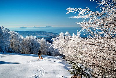
ski lifts, three in Sila (Lorica, PalumboSila and Camigliatello) and one in Aspromonte (Gambarie, where you can ski with a view of the sea). It must be said that in winter there is not always snow on the slopes, as the region is located in southern Italy and is subject to periods of mild weather.
Best Time
The best months for a
beach holiday in Calabria are July and August. In June, the days are long and the weather is often good, but the sea is still a bit cool. You can still go in September, in fact the sea is still quite warm, but the days get shorter and the first waves of bad weather can occur, especially in the second half of the month.
To
visit the cities, you can choose the periods from mid-April to mid-May and from mid-September to mid-October, since in summer it can get very hot. It must be said that in both periods there may be rainy days.
See also the
temperatures by month.