Select units of measurement for the temperature and rainfall tables (metric or imperial).
Average weather, temperature, rainfall, sunshine
In Equatorial Guinea, a small African country located just north of the Equator,
the climate is tropical, hot and humid all year round, with a slightly cooler period from June to September, when the south-west currents prevail.
The country is composed of a continental part, called
Rio Muni, an island, called
Bioko, and a smaller island, called
Annobón.
The
temperatures are higher from January to May and lower from July to September, when they drop to around 27/28 °C (81/82 °F) in the continental part and remain slightly higher on the islands.
The
rains are plentiful, but the rainfall pattern in the mainland is
the opposite to that of the island of Bioko.
The
sea in Equatorial Guinea is warm all year round.
The climate in detail
Bioko
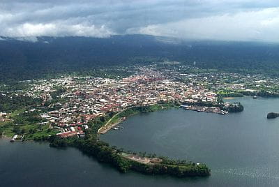
Bioko Island is located at 3 degrees north latitude, near the coast of Cameroon.
Malabo

In the capital,
Malabo, located on the island of
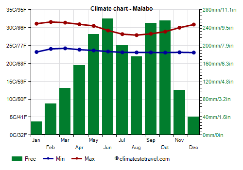
Bioko, the maximum temperatures reach 31.5 °C (88.5 °F) in February and March, the hottest months, while they drop to around 28 °C (82.5 °F) from July to September.
On the island of Bioko, precipitation is below 2,000 mm (80 in) per year in Malabo, while it exceeds 3,000 mm (120 in) per year in the rest of the island.
Here,
the dry season runs from December to February, although it's more pronounced in the northern part, where Malabo is located, while the rainiest period is from May to October.
At no great distance from Malabo, there is the highest peak of Equatorial Guinea,
Pico Basilé, 3,011 meters (9,879 feet) high. The slopes of the volcano are very rainy, but they
protect the capital, which is located on the north coast of the island, in the period from July to October, when it rains more than in the capital also in the eastern and southern coasts of the island.
In the winter months, a hot, dry wind from the mainland can blow. The sky is often cloudy, especially from June to August. With just 1,000 hours of sunshine a year, Malabo is
one of the dullest capitals in the world, in fact, it is usually cloudy, and also foggy. It follows that the vegetation is lush.
On Bioko Island, the
sea is warm all year round, in fact the water temperature reaches up to 29/29.5 °C (84/85 °F) from March to May, while it drops to around 26.5 °C (79.5 °F) in August and September.

Rio Muni
The continental part, known as Rio Muni, extends from 1 to 2 degrees north latitude. Here, precipitation is above 2,000 millimeters (80 inches) per year. Owing to the zenith passages of the sun (that is, when it shines directly overhead in the sky at mid-day), there are
two rainy peaks, from March to May and from September to November, however, the rains are quite abundant even from December to February, especially along the coast, so the only
moderately dry period is from June to August.
Bata

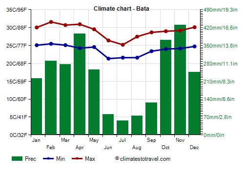
Along the coast of Rio Muni, it is hot all year round, but here too, the temperature decreases slightly from July to September. In
Bata, the main city on the coast, the maximum temperatures in June and July drop to 25/26 °C (77/79 °F). In a year, 2,800 mm (110 in) of rain fall.
The amount of sunshine on the mainland is better than on Bioko Island, however it is not very good, as it does not reach 2,000 hours per year. Here too, the least sunny period is the dry one.
In Bata, the
sea temperature is similar to that of the island of Bioko, in fact the water temperature drops to 26/26.5 °C (79/79.5 °F) from July to September.
Evinayong

The
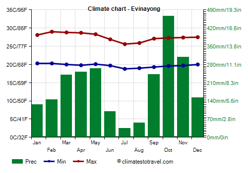
interior is occupied by hills, at an altitude varying from 400 to 700 meters (1,300 to 2,300 feet). At the highest altitudes, the temperature decreases slightly, and in July and August (but also during the rain showers of the rest of the year), it can be quite cool.
In
Evinayong, located at 650 meters (2,100 feet) above sea level, the minimum temperatures drop to around 19 °C (66 °F) from July to September.
On average, 2,400 mm (95 in) of rain fall per year.
Annobón
In addition to the main island, we find a smaller island,
Annobón (or Pigalu), located south of the equator, southwest of the state of São Tomé and Príncipe. Here, the rainfall pattern is similar to that of the mainland, with
a dry season from June to September.
Here, too, the sky is often cloudy.
The
sea temperature is slightly lower in the cool period, and reaches 24 °C (75 °F) in July and August.
When to go
The best time to visit the continental part of
Equatorial Guinea (Rio Muni) is from June to August (while it's from June to September on the island of
Annobón, where there is a similar rainfall pattern).
On the other hand, the best period goes from December to February on the island of
Bioko.
What to pack
For the islands of
Bioko and Annobón, bring tropics-friendly, loose-fitting clothing, and possibly a light sweatshirt for the evening; during the rainy season, an umbrella or a light raincoat. To climb
Pico Basilé, a sweater, a jacket, and hiking boots.
For
Rio Muni, bring tropics-friendly, loose-fitting clothing; during the rainy season, an umbrella or a light raincoat, and possibly a light sweatshirt for the evening. For the hilly inland areas, where the national parks are found, you can add a sweatshirt and a light jacket.
Climate data - Equatorial Guinea
| Bata |
|---|
|
| Jan | Feb | Mar | Apr | May | Jun | Jul | Aug | Sep | Oct | Nov | Dec |
|---|
| Min temp. | 25 | 25 | 25 | 24 | 25 | 21 | 22 | 22 | 23 | 24 | 24 | 25 |
|---|
| Max temp. | 30 | 32 | 31 | 31 | 30 | 26 | 25 | 27 | 29 | 29 | 29 | 30 |
|---|
| Precip. | 220 | 290 | 275 | 395 | 255 | 80 | 55 | 75 | 125 | 370 | 430 | 245 |
|---|
| Prec. days | 14 | 15 | 17 | 19 | 15 | 4 | 3 | 5 | 13 | 22 | 22 | 17 |
|---|
|
|
| Sun hours | 6 | 7 | 6 | 6 | 6 | 5 | 5 | 5 | 4 | 4 | 5 | 6 |
|---|
| Sea temp | 28 | 29 | 29 | 29 | 28 | 27 | 26 | 26 | 26 | 27 | 28 | 28 |
|---|
| Evinayong (680 meters) |
|---|
|
| Jan | Feb | Mar | Apr | May | Jun | Jul | Aug | Sep | Oct | Nov | Dec |
|---|
| Min temp. | 20 | 20 | 20 | 20 | 20 | 20 | 19 | 19 | 19 | 20 | 20 | 20 |
|---|
| Max temp. | 28 | 29 | 29 | 29 | 28 | 27 | 26 | 26 | 27 | 27 | 27 | 28 |
|---|
| Precip. | 125 | 145 | 240 | 250 | 265 | 100 | 35 | 55 | 240 | 465 | 310 | 155 |
|---|
| Prec. days | 10 | 11 | 16 | 17 | 18 | 9 | 6 | 9 | 18 | 23 | 19 | 11 |
|---|
|
|
|
|
| Malabo |
|---|
|
| Jan | Feb | Mar | Apr | May | Jun | Jul | Aug | Sep | Oct | Nov | Dec |
|---|
| Min temp. | 23 | 24 | 24 | 24 | 24 | 23 | 23 | 23 | 23 | 23 | 23 | 23 |
|---|
| Max temp. | 31 | 32 | 31 | 31 | 30 | 29 | 28 | 28 | 28 | 29 | 30 | 31 |
|---|
| Precip. | 30 | 70 | 105 | 155 | 225 | 260 | 200 | 175 | 250 | 255 | 100 | 40 |
|---|
| Prec. days | 4 | 5 | 10 | 12 | 17 | 19 | 18 | 15 | 21 | 20 | 10 | 4 |
|---|
| Humidity | 81% | 81% | 83% | 85% | 87% | 88% | 89% | 89% | 90% | 89% | 88% | 83% |
|---|
| Day length | 12 | 12 | 12 | 12 | 12 | 12 | 12 | 12 | 12 | 12 | 12 | 12 |
|---|
| Sun hours | 4 | 4 | 3 | 4 | 3 | 2 | 1 | 2 | 2 | 2 | 3 | 4 |
|---|
| Sea temp | 28 | 29 | 29 | 29 | 29 | 28 | 27 | 26 | 27 | 27 | 28 | 28 |
|---|
See also the
temperatures month by month