Select units of measurement for the temperature and rainfall tables (metric or imperial).
Average weather, temperature, rainfall, sunshine
In Bhutan, a small Asian country crossed by the Himalayas, the climate is influenced by
altitude: it is subtropical in the lowlands, and becomes progressively colder as you climb the mountains slopes.
In addition, the climate is influenced by the
summer monsoon, which brings rains and widespread cloudiness for almost six months per year, but especially from June to late September.
The
sun in Bhutan shines regularly in winter, while it does not shine very often in the monsoon season. Here are the average daily sunshine hours in Thimphu.
The climate in detail
Plain
In the thin
southernmost lowland region, located between 200 and 450 meters (650 to 1,475 feet) above sea level, in places like Gelephu, Jomotshangkha, Samtse and Phuentsholing, the climate is
subtropical.
Winter is very mild, but sometimes it can get cold at night. Spring, from March to May, is hot, especially in April and May, when the temperature can reach as high as 37/38 °C (98/100 °F), in addition, afternoon thunderstorms become more frequent.
From May to mid-October, it's the monsoon season, with
abundant rainfall, at times torrential, which are enhanced by the proximity to the mountains, and muggy heat.
This is the rainiest area in the country, and receives 4,000 to 5,000 millimeters (157 to 195 inches) per year. Even though the real monsoon has not yet arrived, in May the rains are already very abundant. The best time in this area is from November to February.
Phuntsholing
In
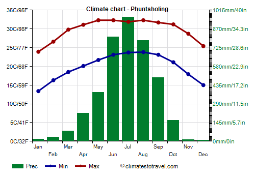
Phuntsholing, located at 240 meters (785 ft) above sea level, near the border with India, beyond which lies the city of Jaygaon, the average temperature ranges from 18.5 °C (65 °F) in January to 28 °C (82.5 °F) in August.
On average, 3,955 mm (155 in) of rain fall per year, with a maximum of almost 1,000 mm (40 in) in July.
Hills and mountains
In
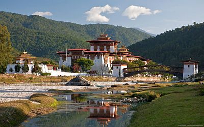
hilly and mountainous areas up to 1,500 meters (5,000 feet), the climate becomes
progressively milder, with relatively cold, dry winters and warm, rainy summers, with monsoon rains on the southern side, while in inland valleys, the summer rains are less intense.
For example, in
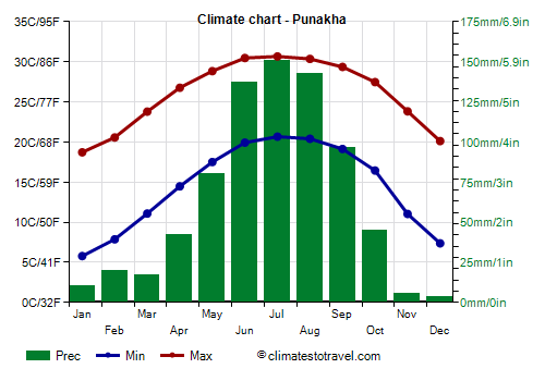
Punakha, located at 1,300 meters (4,250 feet), the average temperature ranges from 12.5 °C (54.5 °F) in January to 25.5 °C (78 °F) in July, so the summer is quite hot and humid despite the altitude.
Rainfall amounts to 750 mm (29.5 in) per year.
Above 2,000 meters (6,500 feet), winter are quite cold, with nights usually below freezing (0 °C or 32 °F).
Thimphu
In the capital,
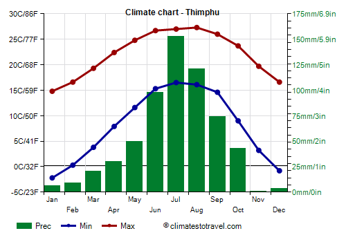
Thimphu, located in a valley, at an altitude varying between 2,200 and 2,600 meters (7,200 and 8,500 ft), the average temperature ranges from 6 °C (43 °F) in January to 21/22 °C (70/72 °F) in the period from June to August. Winter is dry and sunny, but snow can sometimes fall.
In Thimphu, the rains are not abundant, only 610 mm (24 in) per year, although they reach or exceed 70 mm (2.7 in) per month from June to September.
In the nearby city of
Paro, a similar climate is found.
High altitude
Above 2,800 meters (9,200 ft), the daily average temperature in January approaches the freezing mark, and even summer nights become very cool or cold.
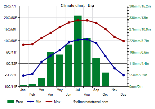
In
Ura, a village located at 3,100 meters (10,150 ft) above sea level, the average temperature ranges from 1.5 °C (34.5 °F) in January to 14.5 °C (58 °F) in July and August.
On average, 1,350 mm (53 in) of rain (or snow) fall per year.
Glaciers and perennial snows begin at
high altitudes, above 5,000 meters (16,400 ft). In the northernmost areas, the summer rains are not very heavy, but the sky in summer is often cloudy, and you can find fogs, or rather clouds lying on the mountain slopes.
The highest peak of Bhutan is
Gangkhar Puensum, 7,570 meters (28,836 feet) high.
Tropical cyclones
Bhutan is too far from the sea to be directly hit by tropical cyclones, but the remains of cyclones affecting Bangladesh can cause heavy rains in the plains as well as snowfalls in the mountains, as happened in May 2009 with Cyclone Aila.
Cyclones typically occur from mid-April to early December, and most likely in May-June and in October-November.
When to go
The best times to visit the mountainous part of Bhutan are
spring and autumn, and particularly the two periods of March-April and mid-October to mid-November.
During the summer, the rains can make the roads muddy, so travelling can be difficult, in addition, clouds can hide the mountain peaks.
In winter, the weather is generally good, but it's cold in the mountains, in addition, snow can fall at high altitudes, and it can also block some passes.
What to pack
In
winter: for the plain, bring spring/autumn clothes (light for the day), a jacket and a sweater for the evening. For Punakha and around 1,500 meters (5,000 feet), bring spring/autumn clothes for the day, warm for the evening, a jacket, a hat, a scarf, sunglasses, sunscreen. For Thimphu and above 2,000 meters (6,500 feet), warm clothes for the evening, but during the day, a fleece and a light jacket may be sufficient; hiking shoes. At higher altitudes, cold weather clothing, synthetic, thermal long underwear, a fleece, a parka, a wind jacket, warm boots.
In
summer: for the plain, bring lightweight clothing of natural fibers, a light raincoat or umbrella. For Punakha and around 1,500 meters (5,000 feet), light clothing, a sweatshirt for the evening, a raincoat or umbrella. For Thimphu and above 2,000 meters (6,500 feet), spring/autumn clothes (light for the day), a sweater and a jacket for the evening. At higher altitudes, a warm jacket, a down jacket, a hat, gloves, a scarf. A sleeping bag and a warm jacket for outdoor overnight stays.
Climate data - Bhutan
| Bhur (375 meters) |
|---|
|
| Jan | Feb | Mar | Apr | May | Jun | Jul | Aug | Sep | Oct | Nov | Dec |
|---|
| Min temp. | 13 | 16 | 18 | 21 | 22 | 23 | 24 | 24 | 24 | 21 | 18 | 15 |
|---|
| Max temp. | 22 | 24 | 26 | 28 | 29 | 29 | 30 | 30 | 30 | 29 | 26 | 24 |
|---|
| Precip. | 15 | 30 | 110 | 210 | 435 | 990 | 1315 | 1035 | 705 | 195 | 15 | 10 |
|---|
| Prec. days | 2 | 3 | 6 | 13 | 19 | 23 | 26 | 24 | 19 | 9 | 2 | 2 |
|---|
|
|
|
|
| Gasa (2,760 meters) |
|---|
|
| Jan | Feb | Mar | Apr | May | Jun | Jul | Aug | Sep | Oct | Nov | Dec |
|---|
| Min temp. | -1 | -1 | 3 | 6 | 8 | 11 | 12 | 12 | 11 | 9 | 2 | 0 |
|---|
| Max temp. | 6 | 10 | 10 | 13 | 16 | 18 | 20 | 21 | 21 | 20 | 18 | 13 |
|---|
| Precip. | 20 | 25 | 95 | 115 | 175 | 310 | 370 | 330 | 200 | 115 | 35 | 10 |
|---|
|
|
|
|
|
| Jakar (2,470 meters) |
|---|
|
| Jan | Feb | Mar | Apr | May | Jun | Jul | Aug | Sep | Oct | Nov | Dec |
|---|
| Min temp. | -4 | -1 | 2 | 6 | 10 | 13 | 14 | 14 | 12 | 7 | 1 | -3 |
|---|
| Max temp. | 11 | 13 | 15 | 18 | 20 | 22 | 23 | 23 | 22 | 19 | 16 | 13 |
|---|
| Precip. | 5 | 10 | 35 | 65 | 95 | 95 | 155 | 140 | 85 | 55 | 5 | 5 |
|---|
| Prec. days | 1 | 2 | 6 | 12 | 16 | 16 | 22 | 20 | 14 | 7 | 1 | 0 |
|---|
|
|
|
|
| Mongar (1,600 meters) |
|---|
|
| Jan | Feb | Mar | Apr | May | Jun | Jul | Aug | Sep | Oct | Nov | Dec |
|---|
| Min temp. | 6 | 8 | 11 | 13 | 15 | 18 | 18 | 18 | 17 | 14 | 10 | 7 |
|---|
| Max temp. | 17 | 19 | 22 | 24 | 25 | 27 | 27 | 27 | 26 | 24 | 21 | 18 |
|---|
| Precip. | 5 | 10 | 40 | 80 | 90 | 135 | 190 | 160 | 110 | 75 | 5 | 5 |
|---|
| Prec. days | 1 | 2 | 5 | 9 | 10 | 13 | 17 | 14 | 10 | 4 | 1 | 1 |
|---|
|
|
|
|
| Paro (2,200 meters) |
|---|
|
| Jan | Feb | Mar | Apr | May | Jun | Jul | Aug | Sep | Oct | Nov | Dec |
|---|
| Min temp. | -1 | 1 | 4 | 7 | 11 | 14 | 15 | 15 | 14 | 9 | 4 | 0 |
|---|
| Max temp. | 13 | 14 | 17 | 20 | 22 | 24 | 24 | 24 | 23 | 20 | 17 | 14 |
|---|
| Precip. | 10 | 15 | 20 | 30 | 60 | 70 | 120 | 110 | 80 | 45 | 0 | 5 |
|---|
| Prec. days | 1 | 2 | 4 | 6 | 10 | 12 | 18 | 17 | 13 | 4 | 0 | 0 |
|---|
|
|
|
|
| Phobjikha (2,860 meters) |
|---|
|
| Jan | Feb | Mar | Apr | May | Jun | Jul | Aug | Sep | Oct | Nov | Dec |
|---|
| Min temp. | -4 | -3 | 0 | 3 | 7 | 10 | 11 | 11 | 10 | 6 | 0 | -4 |
|---|
| Max temp. | 9 | 11 | 13 | 16 | 18 | 20 | 20 | 20 | 19 | 17 | 13 | 11 |
|---|
| Precip. | 5 | 10 | 90 | 185 | 265 | 260 | 495 | 510 | 205 | 105 | 35 | 5 |
|---|
|
|
|
|
|
| Phuntsholing (220 meters) |
|---|
|
| Jan | Feb | Mar | Apr | May | Jun | Jul | Aug | Sep | Oct | Nov | Dec |
|---|
| Min temp. | 13 | 16 | 18 | 20 | 22 | 23 | 24 | 24 | 23 | 21 | 18 | 15 |
|---|
| Max temp. | 24 | 27 | 30 | 31 | 32 | 32 | 32 | 32 | 32 | 31 | 29 | 25 |
|---|
| Precip. | 15 | 30 | 80 | 215 | 380 | 805 | 965 | 780 | 495 | 165 | 15 | 10 |
|---|
|
|
|
|
|
| Punakha (1,235 meters) |
|---|
|
| Jan | Feb | Mar | Apr | May | Jun | Jul | Aug | Sep | Oct | Nov | Dec |
|---|
| Min temp. | 6 | 8 | 11 | 14 | 18 | 20 | 21 | 20 | 19 | 16 | 11 | 7 |
|---|
| Max temp. | 19 | 21 | 24 | 27 | 29 | 30 | 31 | 30 | 29 | 27 | 24 | 20 |
|---|
| Precip. | 10 | 20 | 15 | 40 | 80 | 135 | 150 | 145 | 95 | 45 | 5 | 5 |
|---|
|
|
|
|
|
| Samtse (430 meters) |
|---|
|
| Jan | Feb | Mar | Apr | May | Jun | Jul | Aug | Sep | Oct | Nov | Dec |
|---|
| Min temp. | 13 | 15 | 18 | 20 | 22 | 23 | 24 | 24 | 23 | 21 | 18 | 15 |
|---|
| Max temp. | 21 | 24 | 27 | 28 | 29 | 29 | 28 | 29 | 29 | 29 | 26 | 23 |
|---|
| Precip. | 20 | 40 | 150 | 335 | 635 | 1050 | 1215 | 1065 | 670 | 210 | 20 | 15 |
|---|
| Prec. days | 2 | 4 | 9 | 15 | 21 | 26 | 29 | 28 | 22 | 10 | 3 | 2 |
|---|
|
|
|
|
| Thimphu (2,300 meters) |
|---|
|
| Jan | Feb | Mar | Apr | May | Jun | Jul | Aug | Sep | Oct | Nov | Dec |
|---|
| Min temp. | -2 | 0 | 4 | 8 | 12 | 15 | 16 | 16 | 15 | 9 | 3 | -1 |
|---|
| Max temp. | 15 | 17 | 19 | 22 | 25 | 27 | 27 | 27 | 26 | 24 | 20 | 17 |
|---|
| Precip. | 5 | 10 | 20 | 30 | 50 | 100 | 155 | 120 | 75 | 45 | 0 | 5 |
|---|
| Prec. days | 1 | 1 | 4 | 6 | 9 | 14 | 19 | 17 | 12 | 5 | 0 | 1 |
|---|
|
|
| Sun hours | 8 | 8 | 8 | 8 | 7 | 6 | 5 | 5 | 6 | 8 | 8 | 8 |
|---|
|
| Tshenkharla (1,940 meters) |
|---|
|
| Jan | Feb | Mar | Apr | May | Jun | Jul | Aug | Sep | Oct | Nov | Dec |
|---|
| Min temp. | 4 | 5 | 7 | 11 | 13 | 14 | 15 | 16 | 14 | 11 | 7 | 5 |
|---|
| Max temp. | 14 | 15 | 19 | 22 | 23 | 24 | 25 | 25 | 24 | 21 | 17 | 14 |
|---|
| Precip. | 10 | 20 | 60 | 120 | 120 | 125 | 130 | 150 | 90 | 55 | 5 | 5 |
|---|
|
|
|
|
|
| Ura (3,100 meters) |
|---|
|
| Jan | Feb | Mar | Apr | May | Jun | Jul | Aug | Sep | Oct | Nov | Dec |
|---|
| Min temp. | -5 | -4 | 1 | 3 | 6 | 9 | 10 | 11 | 9 | 3 | -2 | -5 |
|---|
| Max temp. | 8 | 8 | 11 | 13 | 16 | 18 | 19 | 19 | 18 | 15 | 12 | 10 |
|---|
| Precip. | 5 | 15 | 40 | 165 | 150 | 200 | 340 | 230 | 135 | 65 | 5 | 0 |
|---|
|
|
|
|
|
| Wangdue Phodrang (1,200 meters) |
|---|
|
| Jan | Feb | Mar | Apr | May | Jun | Jul | Aug | Sep | Oct | Nov | Dec |
|---|
| Min temp. | 5 | 8 | 11 | 14 | 18 | 20 | 21 | 21 | 20 | 15 | 10 | 6 |
|---|
| Max temp. | 19 | 21 | 24 | 27 | 28 | 30 | 29 | 29 | 28 | 27 | 24 | 21 |
|---|
| Precip. | 5 | 5 | 20 | 40 | 65 | 105 | 145 | 135 | 90 | 45 | 5 | 5 |
|---|
| Prec. days | 1 | 1 | 4 | 7 | 9 | 12 | 17 | 16 | 12 | 5 | 1 | 0 |
|---|
|
|
|
|
See also the
temperatures month by month