Select units of measurement for the temperature and rainfall tables (metric or imperial).
Average weather, temperature, rainfall, sunshine
In Andorra, a small mountainous country located in the Pyrenees between France and Spain, there is a
temperate climate in the lower valleys, and a
mountain climate at high altitudes.
Precipitation (rain or snow) is moderate, generally below 1,000 millimeters (40 inches) per year in the valleys, and is quite frequent, since Atlantic frontal systems affect the country for many months a year. In summer, when the Azores anticyclone prevails, and therefore good weather, thunderstorms can break out in the afternoon.
The amount of
sunshine in Andorra is quite good in summer, when sunny days are frequent, while it is just acceptable in the other months due to the frequent passage of disturbances.
The climate in detail
Main towns
Andorra La Vella

The capital,
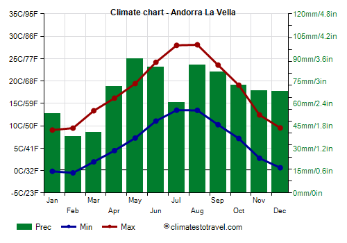
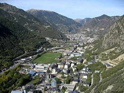
Andorra La Vella, is located at 1,000 meters (3,300 feet) above sea level, in the Valira Valley, in one of the lowest points in the country, the lowest point being Sant Julia de Loria, 840 meters (2,755 feet) above sea level, in the south, near the border with Spain. Here, the climate is not too cold: the average temperature in January is around 3/4 °C (37/39 °F), while in July and August it's 20/21 °C (68/70 °F).
Winter is relatively cold but not freezing, although the night temperature drops quite often a few degrees below 0 °C (32 °F). The wind from the north has foehn-like characteristics, that is of a warm, dry wind that descends from the mountains. However, heavy snowfalls and quite intense frosts may sometimes occur, with lows of around -8/-10 °C (14/18 °F).
Summer is warm during the day, with highs around 28 °C (82.5 °F), but relative humidity is not high, and nights are cool. In the afternoon, thunderstorms can occur.
Sometimes there can be very hot periods, with highs of 35/37 °C (95/99 °F).
At the Roc de Sant Pere station, located at 1,100 meters (3,600 feet) above sea level, the average temperature fluctuates between 4.5 °C (40 °F) in January and February, and almost 21 °C (70 °F) in July and August.

Ransol

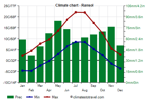
At higher altitudes, above 1,500 meters (5,000 feet), the climate is colder, and the average in January drops below the freezing point.
In
Ransol, located 1,700 meters (5,600 feet) above sea level, the average temperature goes from -1 °C (32 °F) in January to 15.5 °C (60 °F) in July and August.
An average of 750 mm (29.5 in) of rain (or snow, normally from November to April) falls each year. Here too, the relatively driest period runs from December to March, while thunderstorms can break out in late spring and summer.
The average altitude of the country is 1,900 meters (6,200 feet). On
high mountains, heavy snowfalls occur during winter. In the highest peaks, snow can linger on the ground until July. The highest point in the country is Coma Pedrosa, 2,942 meters (9,652 feet) high.
When to go
The best time to visit Andorra runs from
June to mid-September, since it is the least cold in the mountains, while in the valley bottom it's warm but not too much. You should be equipped for cool temperatures at night in the valleys, and even for the cold at high altitudes, as well as for afternoon thunderstorms.
As mentioned, July and August are the warmest months; in July, thunderstorms are generally not as frequent as in August.
What to pack
In
winter: bring warm clothing, a sweater, a down jacket, a hat and gloves.
In
summer: bring light clothes, T-shirts, but also long pants, a jacket and a sweater for the evening and the mountains; hiking shoes, sunscreen and sunglasses, and a raincoat or umbrella.
Climate data - Andorra
| Andorra La Vella (1,100 meters) |
|---|
|
| Jan | Feb | Mar | Apr | May | Jun | Jul | Aug | Sep | Oct | Nov | Dec |
|---|
| Min temp. | 0 | -1 | 2 | 4 | 7 | 11 | 13 | 13 | 10 | 7 | 3 | 1 |
|---|
| Max temp. | 9 | 9 | 13 | 16 | 19 | 24 | 28 | 28 | 24 | 19 | 12 | 10 |
|---|
| Precip. | 55 | 40 | 40 | 70 | 90 | 85 | 60 | 85 | 80 | 70 | 70 | 70 |
|---|
| Prec. days | 6 | 5 | 6 | 9 | 11 | 9 | 7 | 7 | 7 | 8 | 7 | 6 |
|---|
|
| Day length | 10 | 11 | 12 | 14 | 15 | 15 | 15 | 14 | 12 | 11 | 10 | 9 |
|---|
| Sun hours | 5 | 5 | 5 | 6 | 6 | 7 | 9 | 8 | 6 | 5 | 5 | 4 |
|---|
|
| Envalira (2,500 meters) |
|---|
|
| Jan | Feb | Mar | Apr | May | Jun | Jul | Aug | Sep | Oct | Nov | Dec |
|---|
| Min temp. | -7 | -8 | -6 | -3 | 0 | 5 | 8 | 7 | 4 | 1 | -3 | -4 |
|---|
| Max temp. | -1 | -1 | 1 | 3 | 6 | 11 | 14 | 13 | 10 | 7 | 2 | 1 |
|---|
|
|
|
|
|
| Ransol (1,700 meters) |
|---|
|
| Jan | Feb | Mar | Apr | May | Jun | Jul | Aug | Sep | Oct | Nov | Dec |
|---|
| Min temp. | -5 | -5 | -2 | 0 | 3 | 7 | 9 | 9 | 5 | 3 | -1 | -4 |
|---|
| Max temp. | 2 | 5 | 8 | 10 | 14 | 19 | 22 | 22 | 17 | 13 | 6 | 3 |
|---|
| Precip. | 60 | 35 | 50 | 65 | 85 | 75 | 55 | 60 | 65 | 70 | 75 | 50 |
|---|
|
|
|
|
|
See also the
temperatures month by month