Select units of measurement for the temperature and rainfall tables (metric or imperial).
Average weather, temperature, rainfall, sunshine
In North Korea (Democratic People's Republic of Korea), the climate is
continental, with freezing, sunny winters and hot, rainy summers.
The country is affected by the
monsoon circulation: during winter, the cold northwest wind of Siberian origin prevails, while in summer, it is replaced by southern currents of tropical origin.
This explains the
precipitation regime of North Korea, which, for example, is opposite to that of the Mediterranean: the driest months are those of winter, while the highest amount of rainfall is recorded in July and August. The rains brought by the summer monsoon can sometimes be very abundant and cause flooding (as happened, for example, in August 2007 or in July 2012).
In summer and early autumn, the country can be reached by
typhoons.
Generally, North Korea is a
sunny country. There are many sunny days even in winter, while in summer, the sunshine hours decrease a bit because the monsoon brings some periods of bad weather.
The climate in detail
North
In the north, largely occupied by hills and mountains, winter is freezing and sunny, since the air masses of Siberian origin prevail. In summer, temperatures vary with altitude, and at low altitudes it is hot. The rains are concentrated in the May-September period. Even though winter is dry, it can sometimes snow.
Hyesan
In
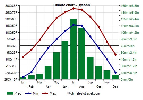
Hyesan, a city located in the far north, on the border with China and at 700 meters (2,300 feet) above sea level, the average January temperature is -15.7 °C (3.7 °F). The temperature drops below -5 °C (23 °F) for 150 days a year, and this happens from October to April. The coldest record is -37.2 °C (-35 °F) and was set in January 1959, while in January 2018 the temperature dropped to -34 °C (-29 °F).
In summer there are quite cool periods, but also hot periods, in which the temperature exceeds 30 °C (86 °F), sometimes as early as the end of May, before the monsoon. The highest record is 38.3 °C (100.9 °F) and was set in August 2016.
Precipitation in the north is quite scarce, and in Hyesan it exceeds 100 mm (4 in) per month only in July and August.
Mountains
In the interior of North Korea, there are
mountainous areas, where the climate gets even colder, and in winter, the temperature in the worst moments can plunge to -40 °C (-40 °F). The highest ranges are found in the northeast, and are the
Rangrim mountains, whose highest peak is Wagalbong, 2,260 meters (7,415 ft) high, and the
Hamgyong Mountains, which include several peaks over 2,000 meters (6,500 feet), the highest of which is Mount Kwanmo, 2,540 meters (8,333 feet) high.
However, the highest peak of the country, and the sacred mountain for the Koreans, is
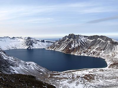
Mount Paektu, also known as Baekdu or Baitou, which is located in the northeast, on the border with China, and it's 2,744 meters (9,003 ft) high. It is a volcano, and its center is occupied by a caldera lake, called "Heaven Lake", which was formed after the big eruption of 946 AD. Snow may cover the top until June.
In
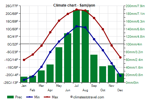
Samjiyon, situated at 1,350 meters (4,400 feet), at the foot of Mount Paektu, the average temperature ranges from -16.7 °C (2 °F) in January to 17.2 °C (63 °F) in July. In 2018, the temperature dropped to -40 °C (-40 °F) in February, while it hit 33.5 °C (92.5 °F) in August.
Another famous mountain is
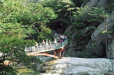
Mount Kumgang, 1,638 meters (5,374 ft) high, located in the south-east, a short distance from the border with South Korea, in the area having a milder climate, and where access is allowed to tourists from South Korea. Here, there is a landscape characterized by its rock formations. In winter, you can find frozen waterfalls.
Sonbong
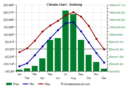
On the north-eastern coast, near the border with Russia, the climate is colder than in the center-south, both because of the higher latitude and because of the presence of a cold sea current, called Liman current.
In
Sonbong, located on the coast, at 42 degrees north latitude, near the border with Siberia and 150 km (90 mi) from Vladivostok, the average temperature ranges from -6.7 °C (20 °F) in January to 21.8 °C (71 °F) in July. Spring is very cool, if not cold, and summer is not particularly warm.
In the north-east, the climate is quite arid, since cold air from the north prevails for much of the year, and the summer monsoon arrives with more difficulty. However, summer is the wettest season here as well.
In the northeast the sea, near the freezing point in winter, remains cool even in summer, and reaches only 21 °C (70 °F) in August.
Center-South
In the central and southern part of North Korea, the climate is milder, however, winter is still very cold, especially on the west coast and in inland areas.
Pyongyang
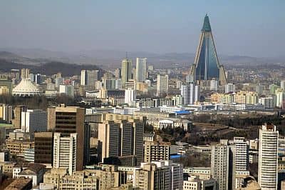
The capital,
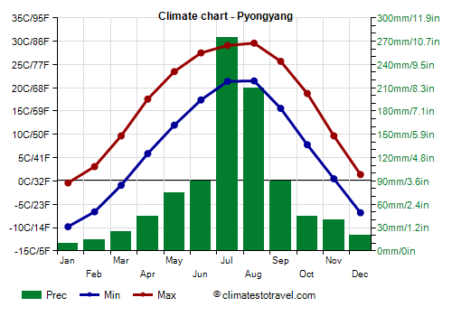
Pyongyang, is located on the western side, about forty kilometers (25 miles) away from the Yellow Sea coast. In winter, during cold spells, the temperature can drop below -20 °C (-4 °F); in January 2001, it dropped to -26.5 °C (-15.5 °F).
Summer is hot and muggy, and in periods of good weather the temperature can reach 34/35 °C (93/95 °F). The highest record is 37.9 °C (100.2 °F) and was set in August 2018.
In Pyongyang, precipitation averages 935 millimeters (37 inches) per year, so it's quite abundant, although it is concentrated from May to September; in winter, it is scarce, and given the temperatures, it occurs in the form of snow.
The sun often shines for most of the year, except in summer, when the monsoon reduces the number of hours of sunshine.
On the west coast of North Korea, the Yellow Sea, very cold in winter, becomes warm enough for swimming in summer, especially in August.
Along the
coasts, the weather is a bit milder, in addition, at a given latitude, the east coast, on the Korean East Sea (or Sea of Japan), is milder than the western coast, on the Yellow Sea.
Wonsan
In
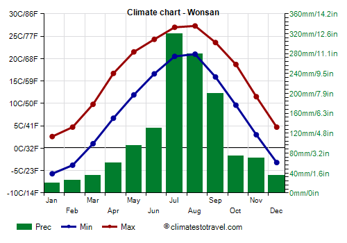
Wonsan, located on the east coast, at the same latitude as Pyongyang, the average January temperature is -1.5 °C (29 °F). In January 2001, the temperature dropped to -18.3 °C (-0.9 °F).
Here too, very hot periods can occur in summer. Actually, the wind that descends from the mountains located southwest of the city can lead to sudden increases in temperature in all seasons. The highest record is 39.7 °C (103.5 °F), set in July 2018.
In Wonsan, 1,350 mm (53 in) of rain fall per year; here, in particular, the month of September is still very rainy.
In Wonsan too, the sun often shines for most of the year, excluding in summer, when the monsoon reduces the number of the sunshine hours.
On the east coast, the sea temperature in summer is 1-2 degrees Celsius lower than on the west coast, and reaches a maximum of 23.5 °C (74.5 °F) in August.
Kosong
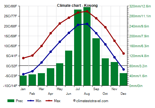
Southeast of Wonsan, winter is even milder, so much so that in
Kosong, near the border with South Korea and at the foot of Mount Kumgang (see below), the average of January goes up to 0 °C (32 °F). In 2018, the temperature dropped to -17 °C (1.5 °F) in January, while it hit 38 °C (100.5 °F) in August.
In this area, the rains are even more abundant, since they amount to 1,500 mm (59 in) per year, and in particular, they exceed 300 mm (12 in) per month in July and August.
Typhoons
As mentioned, during the summer, the DPRK can be reached by
typhoons, the tropical cyclones of East Asia. Typically, typhoons affect Korea from July to early October (and more rarely, also in the second half of June), with a higher probability in the first half of September.
Since typhoons come from the south, they affect more directly South Korea, where they bring the strongest winds and the most intense sea storms; usually, in North Korea, they mostly bring heavy rainfall, which is added to that of the summer monsoon and can cause landslides and floods.
When to go
Considering the winter cold as well as the heat and the rains of summer, the best times to visit North Korea are
spring and autumn, in particular, the months of May and October, though in October, it may already get cold in the northern mountainous and inland areas (where June and September are preferable).
What to pack
In
winter: bring very warm clothes, such as a down jacket, gloves, a scarf, and a hat. Especially for inland and mountainous areas, bring clothing for extreme cold, thermal underwear, a parka, a jacket in Gore-Tex, gloves, a hat, and a scarf.
In
summer: bring light clothing, a light sweatshirt, a light raincoat or umbrella, and a scarf for the wind. In the hills and in the northeast, a sweatshirt and a light jacket for the evening; in high mountains, a jacket and a sweater.
Climate data - North Korea
| Chongjin |
|---|
|
| Jan | Feb | Mar | Apr | May | Jun | Jul | Aug | Sep | Oct | Nov | Dec |
|---|
| Min temp. | -9 | -7 | -2 | 3 | 8 | 13 | 18 | 19 | 14 | 7 | 0 | -6 |
|---|
| Max temp. | 0 | 2 | 6 | 13 | 17 | 20 | 24 | 26 | 23 | 17 | 8 | 2 |
|---|
| Precip. | 10 | 5 | 15 | 30 | 65 | 75 | 125 | 125 | 80 | 35 | 30 | 15 |
|---|
| Prec. days | 4 | 3 | 3 | 4 | 8 | 10 | 12 | 10 | 6 | 4 | 4 | 4 |
|---|
|
|
|
|
| Chunggang (330 meters) |
|---|
|
| Jan | Feb | Mar | Apr | May | Jun | Jul | Aug | Sep | Oct | Nov | Dec |
|---|
| Min temp. | -23 | -18 | -7 | 1 | 8 | 14 | 18 | 17 | 10 | 1 | -8 | -19 |
|---|
| Max temp. | -8 | -2 | 6 | 15 | 23 | 26 | 29 | 28 | 23 | 16 | 4 | -5 |
|---|
| Precip. | 5 | 10 | 15 | 30 | 65 | 90 | 175 | 150 | 60 | 35 | 30 | 15 |
|---|
| Prec. days | 3 | 4 | 5 | 6 | 9 | 10 | 11 | 10 | 6 | 6 | 6 | 5 |
|---|
|
|
| Sun hours | 5 | 6 | 6 | 6 | 6 | 6 | 5 | 5 | 5 | 5 | 4 | 4 |
|---|
|
| Hamhung |
|---|
|
| Jan | Feb | Mar | Apr | May | Jun | Jul | Aug | Sep | Oct | Nov | Dec |
|---|
| Min temp. | -9 | -7 | -1 | 5 | 10 | 16 | 20 | 20 | 14 | 7 | 0 | -6 |
|---|
| Max temp. | 3 | 5 | 10 | 17 | 22 | 25 | 28 | 28 | 25 | 20 | 12 | 5 |
|---|
| Precip. | 10 | 10 | 20 | 45 | 70 | 85 | 205 | 175 | 95 | 40 | 50 | 20 |
|---|
| Prec. days | 4 | 3 | 4 | 5 | 7 | 8 | 12 | 11 | 7 | 5 | 6 | 3 |
|---|
|
|
|
|
| Hyesan (700 meters) |
|---|
|
| Jan | Feb | Mar | Apr | May | Jun | Jul | Aug | Sep | Oct | Nov | Dec |
|---|
| Min temp. | -23 | -20 | -10 | -2 | 5 | 11 | 16 | 15 | 7 | -2 | -10 | -20 |
|---|
| Max temp. | -8 | -3 | 5 | 14 | 21 | 25 | 28 | 27 | 22 | 14 | 3 | -6 |
|---|
| Precip. | 5 | 10 | 10 | 30 | 60 | 85 | 135 | 115 | 50 | 30 | 20 | 10 |
|---|
| Prec. days | 5 | 4 | 6 | 8 | 12 | 14 | 14 | 12 | 7 | 6 | 7 | 6 |
|---|
|
|
|
|
| Kaesong |
|---|
|
| Jan | Feb | Mar | Apr | May | Jun | Jul | Aug | Sep | Oct | Nov | Dec |
|---|
| Min temp. | -8 | -6 | 0 | 6 | 12 | 17 | 21 | 22 | 16 | 8 | 1 | -6 |
|---|
| Max temp. | 2 | 5 | 10 | 17 | 23 | 27 | 28 | 29 | 26 | 20 | 11 | 4 |
|---|
| Precip. | 10 | 20 | 25 | 50 | 95 | 105 | 360 | 285 | 110 | 40 | 40 | 20 |
|---|
| Prec. days | 3 | 4 | 5 | 6 | 7 | 8 | 13 | 11 | 6 | 5 | 6 | 5 |
|---|
|
|
|
|
| Kanggye (300 meters) |
|---|
|
| Jan | Feb | Mar | Apr | May | Jun | Jul | Aug | Sep | Oct | Nov | Dec |
|---|
| Min temp. | -18 | -14 | -5 | 3 | 9 | 15 | 19 | 18 | 11 | 3 | -5 | -15 |
|---|
| Max temp. | -5 | 0 | 8 | 16 | 23 | 28 | 29 | 29 | 24 | 16 | 6 | -3 |
|---|
| Precip. | 10 | 10 | 20 | 40 | 75 | 115 | 205 | 170 | 75 | 45 | 30 | 15 |
|---|
| Prec. days | 5 | 4 | 6 | 8 | 10 | 13 | 14 | 12 | 7 | 7 | 7 | 6 |
|---|
|
|
|
|
| Kimchaek |
|---|
|
| Jan | Feb | Mar | Apr | May | Jun | Jul | Aug | Sep | Oct | Nov | Dec |
|---|
| Min temp. | -8 | -6 | -2 | 4 | 9 | 14 | 19 | 20 | 14 | 8 | 0 | -6 |
|---|
| Max temp. | 2 | 3 | 8 | 14 | 18 | 21 | 25 | 26 | 24 | 18 | 11 | 4 |
|---|
| Precip. | 15 | 15 | 15 | 35 | 60 | 60 | 145 | 135 | 80 | 40 | 35 | 20 |
|---|
| Prec. days | 6 | 4 | 4 | 5 | 7 | 8 | 10 | 9 | 5 | 4 | 4 | 5 |
|---|
|
|
| Sun hours | 6 | 7 | 7 | 8 | 7 | 5 | 5 | 6 | 7 | 7 | 6 | 5 |
|---|
|
| Kosong |
|---|
|
| Jan | Feb | Mar | Apr | May | Jun | Jul | Aug | Sep | Oct | Nov | Dec |
|---|
| Min temp. | -4 | -3 | 2 | 7 | 12 | 17 | 21 | 21 | 16 | 11 | 4 | -2 |
|---|
| Max temp. | 4 | 5 | 10 | 16 | 21 | 24 | 27 | 27 | 24 | 19 | 13 | 6 |
|---|
| Precip. | 40 | 45 | 50 | 70 | 90 | 140 | 305 | 315 | 190 | 110 | 95 | 50 |
|---|
| Prec. days | 4 | 4 | 6 | 6 | 7 | 9 | 12 | 12 | 8 | 5 | 6 | 4 |
|---|
|
|
|
| Sea temp | 8 | 6 | 6 | 9 | 13 | 18 | 22 | 24 | 22 | 18 | 15 | 11 |
|---|
| Nampo |
|---|
|
| Jan | Feb | Mar | Apr | May | Jun | Jul | Aug | Sep | Oct | Nov | Dec |
|---|
| Min temp. | -8 | -5 | 0 | 6 | 12 | 18 | 21 | 22 | 17 | 10 | 2 | -5 |
|---|
| Max temp. | 0 | 3 | 9 | 16 | 22 | 26 | 28 | 29 | 26 | 19 | 10 | 2 |
|---|
| Precip. | 10 | 15 | 15 | 35 | 65 | 80 | 200 | 165 | 70 | 40 | 40 | 20 |
|---|
| Prec. days | 4 | 4 | 4 | 5 | 6 | 7 | 11 | 8 | 6 | 5 | 7 | 6 |
|---|
|
|
|
| Sea temp | 5 | 3 | 4 | 7 | 11 | 18 | 22 | 25 | 23 | 19 | 14 | 9 |
|---|
| Pungsan (1,200 meters) |
|---|
|
| Jan | Feb | Mar | Apr | May | Jun | Jul | Aug | Sep | Oct | Nov | Dec |
|---|
| Min temp. | -21 | -18 | -11 | -3 | 3 | 8 | 13 | 13 | 5 | -2 | -10 | -19 |
|---|
| Max temp. | -6 | -3 | 3 | 11 | 18 | 22 | 24 | 24 | 19 | 13 | 4 | -4 |
|---|
| Precip. | 5 | 5 | 15 | 25 | 50 | 95 | 155 | 130 | 65 | 30 | 20 | 10 |
|---|
| Prec. days | 3 | 4 | 6 | 8 | 10 | 12 | 14 | 13 | 8 | 5 | 6 | 5 |
|---|
|
|
|
|
| Pyongyang |
|---|
|
| Jan | Feb | Mar | Apr | May | Jun | Jul | Aug | Sep | Oct | Nov | Dec |
|---|
| Min temp. | -10 | -7 | -1 | 6 | 12 | 17 | 21 | 22 | 16 | 8 | 0 | -7 |
|---|
| Max temp. | 0 | 3 | 10 | 18 | 24 | 28 | 29 | 30 | 26 | 19 | 10 | 1 |
|---|
| Precip. | 10 | 15 | 25 | 45 | 75 | 90 | 275 | 210 | 90 | 45 | 40 | 20 |
|---|
| Prec. days | 4 | 4 | 4 | 6 | 7 | 8 | 12 | 10 | 6 | 6 | 7 | 6 |
|---|
|
|
| Sun hours | 6 | 7 | 7 | 8 | 8 | 8 | 6 | 7 | 7 | 7 | 6 | 5 |
|---|
|
| Samjiyon (1,350 meters) |
|---|
|
| Jan | Feb | Mar | Apr | May | Jun | Jul | Aug | Sep | Oct | Nov | Dec |
|---|
| Min temp. | -23 | -21 | -15 | -5 | 2 | 7 | 12 | 11 | 3 | -4 | -12 | -20 |
|---|
| Max temp. | -10 | -7 | -1 | 8 | 15 | 20 | 23 | 22 | 17 | 10 | -1 | -9 |
|---|
| Precip. | 15 | 20 | 30 | 45 | 90 | 130 | 190 | 190 | 75 | 40 | 45 | 25 |
|---|
| Prec. days | 9 | 9 | 12 | 11 | 15 | 17 | 17 | 16 | 9 | 9 | 12 | 12 |
|---|
|
|
|
|
| Sinpo |
|---|
|
| Jan | Feb | Mar | Apr | May | Jun | Jul | Aug | Sep | Oct | Nov | Dec |
|---|
| Min temp. | -7 | -6 | -1 | 5 | 10 | 15 | 19 | 20 | 15 | 8 | 1 | -5 |
|---|
| Max temp. | 3 | 4 | 8 | 14 | 19 | 22 | 26 | 27 | 24 | 18 | 11 | 5 |
|---|
| Precip. | 20 | 15 | 15 | 35 | 60 | 60 | 150 | 125 | 85 | 40 | 40 | 15 |
|---|
| Prec. days | 5 | 3 | 4 | 5 | 7 | 7 | 10 | 9 | 6 | 4 | 5 | 4 |
|---|
|
|
|
|
| Sinuiju |
|---|
|
| Jan | Feb | Mar | Apr | May | Jun | Jul | Aug | Sep | Oct | Nov | Dec |
|---|
| Min temp. | -10 | -7 | -1 | 5 | 12 | 17 | 21 | 21 | 15 | 8 | 0 | -8 |
|---|
| Max temp. | -1 | 3 | 9 | 16 | 22 | 26 | 28 | 29 | 26 | 18 | 9 | 0 |
|---|
| Precip. | 5 | 15 | 20 | 55 | 85 | 125 | 250 | 240 | 95 | 80 | 35 | 15 |
|---|
| Prec. days | 2 | 3 | 4 | 6 | 8 | 10 | 13 | 10 | 6 | 6 | 5 | 4 |
|---|
|
|
| Sun hours | 6 | 7 | 7 | 8 | 8 | 7 | 5 | 6 | 7 | 7 | 6 | 6 |
|---|
|
| Sonbong |
|---|
|
| Jan | Feb | Mar | Apr | May | Jun | Jul | Aug | Sep | Oct | Nov | Dec |
|---|
| Min temp. | -12 | -10 | -4 | 2 | 8 | 13 | 18 | 18 | 12 | 5 | -3 | -9 |
|---|
| Max temp. | -2 | 1 | 6 | 12 | 16 | 19 | 23 | 25 | 22 | 16 | 7 | 0 |
|---|
| Precip. | 5 | 10 | 15 | 35 | 85 | 90 | 165 | 155 | 85 | 45 | 25 | 5 |
|---|
| Prec. days | 2 | 3 | 4 | 5 | 10 | 13 | 15 | 12 | 7 | 5 | 4 | 4 |
|---|
|
|
|
| Sea temp | 2 | 1 | 1 | 4 | 8 | 13 | 18 | 21 | 19 | 15 | 9 | 4 |
|---|
| Wonsan |
|---|
|
| Jan | Feb | Mar | Apr | May | Jun | Jul | Aug | Sep | Oct | Nov | Dec |
|---|
| Min temp. | -6 | -4 | 1 | 7 | 12 | 17 | 20 | 21 | 16 | 10 | 3 | -3 |
|---|
| Max temp. | 3 | 5 | 10 | 17 | 22 | 24 | 27 | 27 | 24 | 19 | 12 | 5 |
|---|
| Precip. | 20 | 25 | 35 | 60 | 95 | 130 | 320 | 280 | 200 | 75 | 70 | 35 |
|---|
| Prec. days | 4 | 4 | 5 | 6 | 8 | 10 | 14 | 13 | 8 | 6 | 6 | 4 |
|---|
|
|
| Sun hours | 7 | 7 | 8 | 8 | 8 | 7 | 6 | 6 | 7 | 7 | 6 | 6 |
|---|
| Sea temp | 6 | 5 | 5 | 8 | 12 | 17 | 21 | 24 | 22 | 18 | 14 | 10 |
|---|
See also the
temperatures month by month