Select units of measurement for the temperature and rainfall tables (metric or imperial).
Average weather, temperature, rainfall, sunshine hours
Molise is a small region of south-central Italy, crossed by the Apennines in the interior and facing the Adriatic Sea to the east, and has a mild climate on the coast, and gradually colder as you go up in altitude and move away from the sea.
Precipitation in Molise is not abundant on the coast, where it amounts to about 600 mm (23.5 in) per year, while it is abundant in the mountains, where it exceeds 1,500 mm (60 in) per year.
The coast
On the coast, the climate is
Mediterranean. Winters are mild and quite rainy, while summers are hot and sunny, with rare rainy days and some thunderstorms.
Despite the mild climate, in winter there can be cold and windy periods, and sometimes it can even snow. In summer there can be hot and muggy periods, but also torrid days when the sirocco blows from Africa, with highs of 38/40 °C (100/104 °F).

In
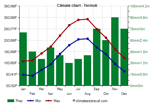
Termoli, located on the Adriatic coast, the average temperature ranges from 8 °C (46.5 °F) in January to 25 °C (77 °F) in July and August. Here are the average temperatures.
Termoli - Average temperatures (1991-2006) |
| Month | Min | Max | Mean |
|---|
| January | 4.9 | 10.8 | 7.8 |
|---|
| February | 4.4 | 11.2 | 7.8 |
|---|
| March | 7 | 14.2 | 10.6 |
|---|
| April | 9.5 | 17.2 | 13.3 |
|---|
| May | 14 | 22 | 18 |
|---|
| June | 17.8 | 26.6 | 22.2 |
|---|
| July | 20.4 | 29 | 24.7 |
|---|
| August | 20.7 | 29.3 | 25 |
|---|
| September | 16.9 | 24.9 | 20.9 |
|---|
| October | 13.9 | 21.1 | 17.5 |
|---|
| November | 9.6 | 16 | 12.8 |
|---|
| December | 6.3 | 12.2 | 9.3 |
|---|
| Year | 12.2 | 19.6 | 15.85 |
|---|
On the coast of Molise, the
sea is warm enough for swimming from July to September, while it is still a little cool in June.
Termoli - Sea temperature| Month |
|---|
| January | 14.5 |
|---|
| February | 14 |
|---|
| March | 14 |
|---|
| April | 15 |
|---|
| May | 18.5 |
|---|
| June | 22 |
|---|
| July | 25 |
|---|
| August | 26 |
|---|
| September | 24 |
|---|
| October | 21 |
|---|
| November | 18"> |
|---|
| December | 16 |
|---|
| Year | 19 |
|---|
Inland areas
As the altitude increases, the climate becomes
moderately continental at hill altitudes. In winter, during cold spells from the north-east, there can be snowfalls and frosts, while in summer, during invasions of hot air from Africa, the temperature can reach 38/40 °C (100/104 °F).
In
Isernia, the second provincial capital, located in the western part of the region at an altitude of 470 metres (1,550 ft), the average temperature is of 6/7 °C (43/44 °F) in January, and 24 °C (75 °F) in July and August.
Isernia - Average temperatures (1961-1990) |
| Month | Min | Max | Mean |
|---|
| January | 2.2 | 9.6 | 5.9 |
|---|
| February | 2.6 | 10.5 | 6.6 |
|---|
| March | 4.8 | 13.1 | 9 |
|---|
| April | 7.6 | 16.7 | 12.1 |
|---|
| May | 11 | 21.4 | 16.2 |
|---|
| June | 14.5 | 26 | 20.2 |
|---|
| July | 17 | 29.1 | 23 |
|---|
| August | 17.1 | 29.8 | 23.5 |
|---|
| September | 14.8 | 25.4 | 20.1 |
|---|
| October | 9.9 | 18.7 | 14.3 |
|---|
| November | 6.3 | 13.5 | 9.9 |
|---|
| December | 4.5 | 11.4 | 8 |
|---|
| Year | 9.4 | 18.8 | 14.05 |
|---|

In the
Apennines, above 700 metres (2,300 ft), the climate becomes
temperate. In summer, there is often sunshine in the morning, but thunderstorms can break out in the afternoon, although not as often as in the Alps.
In
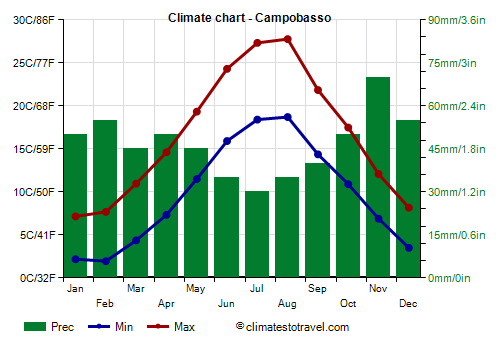
Campobasso, the regional capital, located at an altitude of 700 metres (2,300 ft), the average temperature is 4.5 °C (40 °F) in January, and 23 °C (73.5 °F) in July and August.
Campobasso - Average temperatures (1991-2020) |
| Month | Min | Max | Mean |
|---|
| January | 2.2 | 7.2 | 4.7 |
|---|
| February | 2 | 7.7 | 4.8 |
|---|
| March | 4.4 | 11 | 7.7 |
|---|
| April | 7.3 | 14.6 | 11 |
|---|
| May | 11.5 | 19.3 | 15.4 |
|---|
| June | 15.9 | 24.3 | 20.1 |
|---|
| July | 18.4 | 27.3 | 22.9 |
|---|
| August | 18.7 | 27.8 | 23.2 |
|---|
| September | 14.4 | 21.8 | 18.1 |
|---|
| October | 10.9 | 17.5 | 14.2 |
|---|
| November | 6.9 | 12.1 | 9.5 |
|---|
| December | 3.5 | 8.2 | 5.8 |
|---|
| Year | 9.7 | 16.6 | 13.15 |
|---|
Precipitation is not abundant, amounting to 560 mm (22 in) per year.
Campobasso - Average precipitation| Month | Days |
|---|
| January | 50 | 7 |
|---|
| February | 55 | 8 |
|---|
| March | 45 | 8 |
|---|
| April | 50 | 8 |
|---|
| May | 45 | 7 |
|---|
| June | 35 | 5 |
|---|
| July | 30 | 4 |
|---|
| August | 35 | 5 |
|---|
| September | 40 | 6 |
|---|
| October | 50 | 7 |
|---|
| November | 70 | 9 |
|---|
| December | 55 | 8 |
|---|
| Year | 560 | 82 |
|---|
During cold waves, there can be heavy snowfalls, and the temperature can drop several degrees below freezing. In Campobasso, generally the temperature does not drop below -7/-8 °C (18/19 °F), however, in January 1968 it dropped to -11 °C (12.5 °F), while at the end of February 2018 it dropped to -10 °C (14 °F).

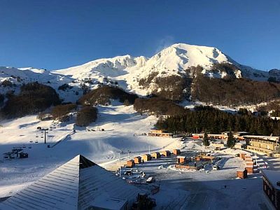
In Molise there are two
ski lifts, near Campitello Matese and Capracotta. It must be said that in winter there is not always snow on the slopes, as the region is located in south-central Italy and is subject to periods of mild weather.
The highest altitude in the region is reached in the Monti della Meta, at 2,170 metres (7,119 ft), although the summit, Monte Petroso, is located in Abruzzo.
In the south-west of the region too, on the border with Campania, in the Matese massif, the 2,000-meter height is exceeded in Monte Miletto, of 2,050 metres (6,725 ft).

In
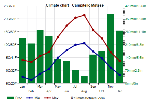
Campitello Matese, located at an altitude of 1,450 metres (4,755 ft), the average temperature ranges from 0 °C (32 °F) in February to 16 °C (61 °F) in August. In winter, the temperature can drop to -10 °C (14 °F), and occasionally to -15 °C (5 °F), while in summer it can reach 27/28 °C (81/82 °F), and occasionally up to 30 °C (86 °F).
Campitello Matese - Average temperatures (1991-2005) |
| Month | Min | Max | Mean |
|---|
| January | -2.5 | 4.1 | 0.8 |
|---|
| February | -3.6 | 3.3 | -0.2 |
|---|
| March | -1.2 | 5.6 | 2.2 |
|---|
| April | 0.6 | 7.1 | 3.9 |
|---|
| May | 4.9 | 12.9 | 8.9 |
|---|
| June | 7.9 | 17.4 | 12.6 |
|---|
| July | 9.9 | 20.4 | 15.2 |
|---|
| August | 10.6 | 21.4 | 16 |
|---|
| September | 7.4 | 15.7 | 11.5 |
|---|
| October | 4.7 | 12.4 | 8.6 |
|---|
| November | 1.1 | 7 | 4.1 |
|---|
| December | -1.8 | 3.7 | 1 |
|---|
| Year | 3.2 | 11 | 7.1 |
|---|
Precipitation is abundant, amounting to 2,350 mm (92.5 in) per year.
Campitello Matese - Average precipitation| Month | Days |
|---|
| January | 245 | |
|---|
| February | 215 | |
|---|
| March | 290 | |
|---|
| April | 255 | |
|---|
| May | 130 | |
|---|
| June | 120 | |
|---|
| July | 70 | |
|---|
| August | 40 | |
|---|
| September | 155 | |
|---|
| October | 175 | |
|---|
| November | 375 | |
|---|
| December | 285 | |
|---|
| Year | 2360 | |
|---|
Best Time
The best months for a
beach holiday in Molise are July and August. In June, the days are long and the weather is often good, but the sea is still a bit cool. You can still go in September, in fact the sea is still quite warm, but the days get shorter and the first waves of bad weather can occur, especially in the second half of the month.
To
visit the cities, at least at medium-low altitudes, you can choose the periods from mid-April to mid-May and from mid-September to mid-October, since in summer it can get very hot. It must be said that in both periods there may be rainy days.
In the
mountains, you can go both in winter, perhaps for skiing, and in summer, perhaps for trekking.
See also the
temperatures by month.