Select units of measurement for the temperature and rainfall tables (metric or imperial).
Average weather, temperature, rainfall, sunshine
In Guyana (formerly British Guiana), a South American country which overlooks the Atlantic Ocean in the north and touches the Equator in the extreme south, the
climate is hot and humid all year round.
As regards to the rainfall, there are
two rainy seasons (from November to January and from late April to mid-August) and
two relatively dry seasons (typically, February-March and September-October). Both duration and intensity of rainfall vary depending on area, but the period May-August is very rainy everywhere.
In the areas that don't have a real dry season, we can speak of
equatorial climate, otherwise, of
tropical climate. The rains mainly occur in the form of heavy showers and thunderstorms, usually in the afternoon or evening.
Guyana does not get a lot of
sun in the rainy months, while in the dry periods, the sky is usually clear, even though a bit of cloudiness may develop at any time.
The
sea in Guyana is warm enough for swimming all year round, in fact, the water temperature ranges from 26 °C (79 °F) to 28 °C (82 °F).
The climate in detail
The forest
Most of Guyana is occupied by the forest, which means that the rains are constant throughout the year, or that there are short and not very pronounced dry seasons.
Georgetown
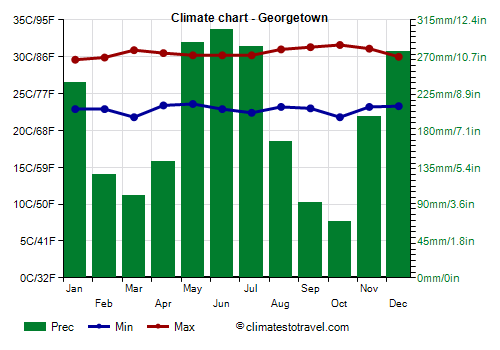
In the capital,
Georgetown, as in the rest of the country, the
temperature is fairly constant throughout the year; daytime temperatures are slightly higher in September and October and slightly lower in the period from December to March. At least, in the capital, as generally happens along the coast, the heat of the day is cooled by the ocean breeze.
In the central-eastern parts of the coast, where Georgetown is located, between the two relatively dry seasons, that of September-October is slightly more evident than that of February-March, in any case, there is no real dry season. In Georgetown, 2,280 millimeters (89.8 inches) of rain fall per year. The wettest month is June, with 305 mm (12 in) of rain.
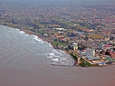
In the other coastal areas of Guyana, it is hot all year round as in the capital, but the rains follow a slightly different pattern depending on the area.
Mabaruma
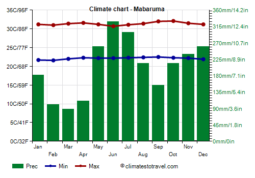
In the
north-west of Guyana, near the border with Venezuela, even September and October are quite rainy, with more than 150 mm (6 in) of rain per month, while from February to April, when around 100 mm (4 in) of rain fall per month, the decrease in rainfall is more noticeable.
The savanna
In the
south-west, towards the border with the Brazilian state of Roraima, we find the area of the
savannah, where the climate is
tropical, with
a dry season from October to March, characterized by intense heat.
Lethem
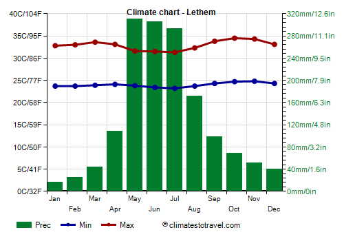
For example, in
Lethem, less than 50 mm falls per month from November to March and around 70 mm in October. Rainfall amounts to 1,500 mm (59 in) per year. In April and September, the rains are moderate, while they are
heavy from May to July.
In October and November, the hottest months, highs exceed 34 °C (93 °F).
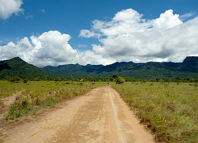
In addition to the strip along the border where Lethem is located, called North Rupununi Savannah, there is a more extensive area of savannah, called South Rupununi Savannah, located south of the Kanuku Mountains (a low mountain range covered by forests).
North of the Rupununi Savannahs, there is a mountain range, the
Sierra Pacaraima, culminating in Mount Roraima, which has its summit in Venezuela, but which exceeds 2,200 meters (7,200 ft) in the Guyanese part. Other peaks are Mount Ayanganna, 2,041 meters (6,696 feet) high, and Mount Caburaì, 1,465 meters (4,806 feet) high.
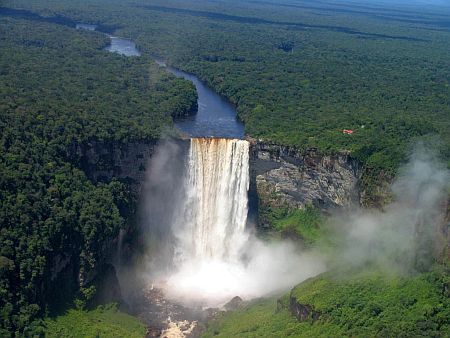
Obviously, the temperature decreases with increasing altitude, and although we are near the Equator, the air is cool above 1,500 meters (5,000 feet). On the northern slopes of this mountain range, precipitation reaches 3,500 mm (138 in) per year. In these mountains, the Potaro River, which then feeds the huge and spectacular
Kaieteur Falls, has its source.
Hurricanes
Guyana is outside of the path of hurricanes, which pass to the north, on the Caribbean Sea. However, it can not be ruled out that some of the rare hurricanes that pass at a very low latitude, affecting Trinidad and Tobago and the northeastern coast of Venezuela, may also produce some effects on Guyana, in terms of rain and anomalous waves on the coast, especially in the northernmost part. The hurricane season in the Caribbean goes from June to November, though they are more likely from August to October.
When to go
The best time to visit Guyana depends mainly on the rain pattern, which is not the same throughout the country.
In the
north-west (see Mabaruma), the best period is February-March.
In
Georgetown and in the central area, the best periods are September-October and February-March.
In the
east, the best period is September-October, but it extends until November (so, it goes from September to November).
In the
south-western savannah area (see Lethem), you can go from October to March.
If you want to choose a single period for the whole country, you can choose
February and March.
What to pack
Throughout the year: bring
lightweight clothing of natural fibers, possibly with long sleeves for mosquitoes; a light sweatshirt, a sun hat, and an umbrella or a lightweight, breathable raincoat.
When going mountain climbing, bring hiking shoes and a sweatshirt.
From December to March, add a sweatshirt for the evening.
Climate data - Guyana
| Cheddi Jagan Airport |
|---|
|
| Jan | Feb | Mar | Apr | May | Jun | Jul | Aug | Sep | Oct | Nov | Dec |
|---|
| Min temp. | 21 | 21 | 21 | 22 | 23 | 23 | 22 | 22 | 22 | 22 | 22 | 22 |
|---|
| Max temp. | 30 | 30 | 31 | 32 | 31 | 31 | 31 | 32 | 33 | 33 | 32 | 31 |
|---|
| Precip. | 225 | 140 | 115 | 190 | 340 | 360 | 300 | 230 | 150 | 135 | 195 | 265 |
|---|
| Prec. days | 17 | 13 | 11 | 12 | 21 | 21 | 23 | 17 | 11 | 10 | 14 | 20 |
|---|
|
|
|
|
| Georgetown |
|---|
|
| Jan | Feb | Mar | Apr | May | Jun | Jul | Aug | Sep | Oct | Nov | Dec |
|---|
| Min temp. | 23 | 23 | 22 | 23 | 24 | 23 | 22 | 23 | 23 | 22 | 23 | 23 |
|---|
| Max temp. | 30 | 30 | 31 | 30 | 30 | 30 | 30 | 31 | 31 | 32 | 31 | 30 |
|---|
| Precip. | 240 | 125 | 100 | 140 | 285 | 305 | 280 | 165 | 90 | 70 | 195 | 275 |
|---|
| Prec. days | 15 | 12 | 10 | 11 | 19 | 22 | 21 | 14 | 7 | 8 | 12 | 19 |
|---|
| Humidity | 78% | 74% | 73% | 73% | 80% | 79% | 81% | 76% | 76% | 71% | 79% | 77% |
|---|
| Day length | 12 | 12 | 12 | 12 | 12 | 12 | 12 | 12 | 12 | 12 | 12 | 12 |
|---|
| Sun hours | 7 | 7 | 8 | 7 | 6 | 6 | 6 | 8 | 8 | 8 | 7 | 6 |
|---|
| Sea temp | 27 | 27 | 27 | 27 | 27 | 28 | 28 | 29 | 29 | 28 | 28 | 27 |
|---|
| Lethem |
|---|
|
| Jan | Feb | Mar | Apr | May | Jun | Jul | Aug | Sep | Oct | Nov | Dec |
|---|
| Min temp. | 24 | 24 | 24 | 24 | 24 | 23 | 23 | 24 | 24 | 25 | 25 | 24 |
|---|
| Max temp. | 33 | 33 | 34 | 33 | 32 | 32 | 31 | 32 | 34 | 34 | 34 | 33 |
|---|
| Precip. | 15 | 25 | 45 | 110 | 310 | 305 | 295 | 170 | 100 | 70 | 50 | 40 |
|---|
| Prec. days | 3 | 3 | 3 | 8 | 17 | 18 | 19 | 13 | 8 | 4 | 3 | 5 |
|---|
|
|
| Sun hours | 8 | 7 | 7 | 6 | 6 | 5 | 6 | 7 | 8 | 8 | 8 | 8 |
|---|
|
| Mabaruma |
|---|
|
| Jan | Feb | Mar | Apr | May | Jun | Jul | Aug | Sep | Oct | Nov | Dec |
|---|
| Min temp. | 22 | 22 | 22 | 22 | 22 | 22 | 22 | 22 | 22 | 22 | 22 | 22 |
|---|
| Max temp. | 31 | 31 | 31 | 32 | 31 | 31 | 31 | 31 | 32 | 32 | 32 | 31 |
|---|
| Precip. | 180 | 100 | 90 | 110 | 260 | 330 | 300 | 215 | 155 | 215 | 240 | 260 |
|---|
| Prec. days | 14 | 11 | 10 | 9 | 18 | 22 | 21 | 17 | 14 | 16 | 18 | 18 |
|---|
|
|
|
|
| New Amsterdam |
|---|
|
| Jan | Feb | Mar | Apr | May | Jun | Jul | Aug | Sep | Oct | Nov | Dec |
|---|
| Min temp. | 23 | 23 | 23 | 24 | 24 | 24 | 24 | 24 | 24 | 24 | 24 | 24 |
|---|
| Max temp. | 30 | 30 | 31 | 31 | 31 | 31 | 31 | 32 | 33 | 33 | 32 | 30 |
|---|
| Precip. | 175 | 120 | 95 | 150 | 280 | 275 | 255 | 155 | 85 | 55 | 145 | 225 |
|---|
| Prec. days | 13 | 11 | 9 | 12 | 18 | 18 | 16 | 11 | 6 | 5 | 9 | 14 |
|---|
|
|
| Sun hours | 6 | 7 | 7 | 6 | 5 | 6 | 7 | 8 | 8 | 8 | 8 | 5 |
|---|
| Sea temp | 27 | 27 | 27 | 27 | 27 | 28 | 28 | 28 | 28 | 28 | 28 | 27 |
|---|