Select units of measurement for the temperature and rainfall tables (metric or imperial).
Average weather, temperature, rainfall, sunshine
In French Guiana there is a
tropical climate, hot and humid throughout the year, with a relatively dry, slightly warmer season from July to November and a rainy season from December to June.
Precipitation is definitely abundant, in fact, it exceeds 2,500 millimeters (100 inches) per year, and in many areas, it even exceeds 3,000 mm (120 in).
The
humidity is high throughout the year, making the heat sweltering, especially in the interior, while on the coast, at least the breeze blows. The most humid period is that of the heavy rains, from April to June, while the humidity is lower in the least rainy and warmest period, from August to October.
French Guiana is a South American country, located just north of the Equator and facing the Atlantic Ocean.
The climate in detail
The seasons
Within the rainy season (which, as we said, goes from December to June), we can distinguish between three periods:
- the first rainy season, in
December and January. This is due to the fact that the intertropical convergence zone (ITCZ) passes over the country from north to south. The northeast trade winds blow with moderate intensity on the coast, and the sea can be rough.
- the short dry season, called
the short summer of March, which may also occur in February. This happens because the ITCZ is by now to the south of the country, so the weather tends to be sunny, but owing to its brevity (one or two weeks), it is not reliable, in any case, it's more evident in the northwest (see St. Laurent du Maroni) than in the south. In this period, the wind can even bring dust from the Sahara desert.
- the long rainy season,
from April to June, with the peak in May, when the ITCZ arrives again, this time from the south, bringing a lot of heat and humidity from the Amazon rainforest. The wind is weaker, and the humidity makes the heat stifling. The rains are more abundant, and they are often torrential, along the central and eastern part of the coast (see Cayenne, Saint-Georges-de-l'Oyapock), where they can easily create flooding. In May and June, more than 300 mm (12 in) of rain fall per month in St. Laurent du Maroni, and even more than 500 mm (20 in) in a single month (May) in Cayenne and in Saint-Georges-de-l'Oyapock, in the east. In this period, it rains almost every day.
During the dry season,
from July to November, the ITCZ is located to the north, but not by much, and in any case, thunderstorms can form in inland areas and the move towards the coast. In September and October, the least rainy months, rainfall amounts to around 55/60 millimeters (2.2/2.4 inches) per month in Cayenne, a little more in Maripasoula, in the west, where it's around 70/80 mm (2.7/3.1 in) per month, and even more in St. Laurent du Maroni, in the far north-west, where it's around 100 mm (4 in) per month, but it is still lower than in the rest of the year.
Cayenne
 Cayenne
, the capital, is located in the central part of the coast.
Temperatures are high all year round: lows are always above 20 °C (68 °F), while highs range from 29/30 °C (84/86 °F) between January and May to 32.5 °C (90.5 °F) in September and October, which are the hottest months because they are the driest and sunniest. However, at this time, the humidity is a bit lower, around 65% during the warmest hours, while in the rest of the year, it exceeds 70%. Here are the average temperatures.
On the hottest days, from May to November, the temperature can still reach 34/35 °C (93/95 °F), here and in other parts of the coast, while in inland areas it can reach 37/38 °C (99/100.5 °F) .
In Cayenne, total annual rainfall is up to 3,500 mm (138 in).
There is not much
sun in the wet season, from December to June, when there are about 3/5 hours of sunshine per day, while the sun shines quite frequently from July to November, when the average rises to 7/8 hours per day.
Sea temperature
The
sea is warm enough for swimming all year round, since the water temperature is around 27/28 °C (81/82 °F).
The sea is not particularly clear and has often a brown color (except in the islets that are located offshore) because of the large quantity of water coming from rivers, although it is generally clean (except in the vicinity of the cities). It's better to swim at high tide, since during low tide, the uncovered part of the beach can remain muddy.
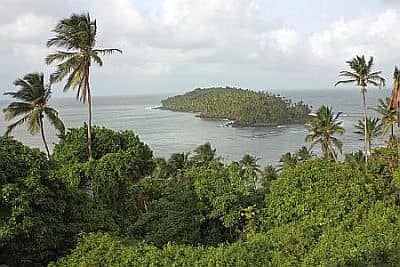 Devil's Island
Off the coast, there are some small islands, such as the famous Devil's Island, with a climate similar to that of the coast.
Hurricanes
French Guyana is outside of the path of hurricanes, which pass more to the north, over the Caribbean Sea.
However, from December to April, the coast can sometimes be reached by
abnormal waves, generated by Atlantic depressions that pass far to the north.
When to go
The best time to visit French Guiana is
from mid-August to mid-November, and in particular, the months of September and October, which are the least rainy and the sunniest, especially on the eastern part of the country. This is also the hottest period, but it is not as humid as the rest of the year, and in any case, what matters most is to avoid the heavy rains.
What to pack
Throughout the year: bring
lightweight clothing of natural fibers, possibly with long sleeves for mosquitoes, a light sweatshirt for the rain showers or the sea breeze, a sun hat, and an umbrella (though it can be useless for heavy showers) or a lightweight and breathable raincoat.
From December to March, you can add a sweatshirt for the evening.
Climate data - French Guiana
| Cayenne |
|---|
|
| Jan | Feb | Mar | Apr | May | Jun | Jul | Aug | Sep | Oct | Nov | Dec |
|---|
| Min temp. | 23 | 24 | 24 | 24 | 24 | 23 | 22 | 22 | 22 | 22 | 23 | 23 |
|---|
| Max temp. | 29 | 29 | 30 | 30 | 30 | 30 | 31 | 32 | 32 | 32 | 32 | 30 |
|---|
| Precip. | 400 | 335 | 315 | 445 | 600 | 390 | 260 | 135 | 65 | 55 | 135 | 350 |
|---|
| Prec. days | 23 | 20 | 20 | 22 | 27 | 25 | 21 | 14 | 6 | 6 | 12 | 22 |
|---|
| Humidity | 85% | 84% | 83% | 85% | 87% | 87% | 86% | 83% | 80% | 80% | 82% | 85% |
|---|
| Day length | 12 | 12 | 12 | 12 | 12 | 12 | 12 | 12 | 12 | 12 | 12 | 12 |
|---|
| Sun hours | 3 | 3 | 4 | 4 | 4 | 5 | 6 | 8 | 8 | 8 | 7 | 5 |
|---|
| Sea temp | 27 | 27 | 27 | 28 | 28 | 28 | 28 | 28 | 28 | 28 | 28 | 28 |
|---|
| Maripasoula |
|---|
|
| Jan | Feb | Mar | Apr | May | Jun | Jul | Aug | Sep | Oct | Nov | Dec |
|---|
| Min temp. | 22 | 22 | 23 | 23 | 23 | 23 | 22 | 22 | 22 | 22 | 22 | 23 |
|---|
| Max temp. | 31 | 31 | 32 | 32 | 32 | 32 | 32 | 33 | 34 | 34 | 34 | 32 |
|---|
| Precip. | 225 | 235 | 240 | 285 | 355 | 280 | 205 | 160 | 60 | 70 | 110 | 195 |
|---|
| Prec. days | 21 | 20 | 19 | 21 | 26 | 23 | 20 | 16 | 8 | 8 | 11 | 19 |
|---|
|
|
| Sun hours | 5 | 5 | 5 | 6 | 5 | 6 | 7 | 8 | 9 | 9 | 8 | 6 |
|---|
|
| Saint Georges Oyapock |
|---|
|
| Jan | Feb | Mar | Apr | May | Jun | Jul | Aug | Sep | Oct | Nov | Dec |
|---|
| Min temp. | 22 | 23 | 23 | 23 | 23 | 23 | 22 | 22 | 22 | 22 | 22 | 22 |
|---|
| Max temp. | 30 | 30 | 30 | 30 | 30 | 31 | 32 | 33 | 34 | 34 | 33 | 31 |
|---|
| Precip. | 395 | 390 | 375 | 470 | 545 | 330 | 210 | 100 | 40 | 45 | 115 | 295 |
|---|
| Prec. days | 24 | 21 | 22 | 23 | 27 | 24 | 19 | 10 | 4 | 5 | 11 | 20 |
|---|
|
|
| Sun hours | 3 | 3 | 3 | 3 | 3 | 4 | 6 | 7 | 8 | 8 | 6 | 4 |
|---|
| Sea temp | 28 | 28 | 28 | 28 | 28 | 29 | 28 | 28 | 28 | 28 | 28 | 28 |
|---|
| Saint Laurent Maroni |
|---|
|
| Jan | Feb | Mar | Apr | May | Jun | Jul | Aug | Sep | Oct | Nov | Dec |
|---|
| Min temp. | 22 | 23 | 23 | 23 | 24 | 23 | 23 | 23 | 23 | 23 | 23 | 23 |
|---|
| Max temp. | 30 | 30 | 30 | 31 | 31 | 31 | 32 | 33 | 34 | 34 | 33 | 31 |
|---|
| Precip. | 215 | 215 | 175 | 265 | 355 | 310 | 190 | 145 | 80 | 90 | 150 | 200 |
|---|
| Prec. days | 18 | 16 | 16 | 18 | 22 | 21 | 19 | 15 | 9 | 9 | 14 | 18 |
|---|
|
|
|
| Sea temp | 27 | 27 | 27 | 27 | 28 | 28 | 28 | 28 | 28 | 28 | 28 | 27 |
|---|
| Saul |
|---|
|
| Jan | Feb | Mar | Apr | May | Jun | Jul | Aug | Sep | Oct | Nov | Dec |
|---|
| Min temp. | 22 | 22 | 22 | 22 | 22 | 21 | 21 | 21 | 21 | 21 | 21 | 22 |
|---|
| Max temp. | 31 | 31 | 32 | 32 | 32 | 32 | 33 | 33 | 34 | 34 | 34 | 32 |
|---|
| Precip. | 240 | 260 | 265 | 330 | 350 | 265 | 200 | 135 | 70 | 70 | 125 | 210 |
|---|
| Prec. days | 23 | 22 | 22 | 22 | 26 | 24 | 20 | 14 | 8 | 8 | 12 | 21 |
|---|
|
|
|
|