Select units of measurement for the temperature and rainfall tables (metric or imperial).
Average weather, temperature, rainfall, sunshine
In Togo, an African country located to the south of the Sahara, the climate is
tropical, with a dry season in winter and a rainy season due to the African monsoon, which runs from April to October in the center and from May to October in the north, while along the coast, there is a marked decrease in rainfall from July to September.
The
rainfall amounts to 900 millimeters (35.5 inches) per year on the coast, 1,000 mm (40 in) in the far north (Savanes Region), 1,300/1,400 mm (51/55 in) in the central and northern inland areas, and up to 2,000 mm (80 in) in the western part of the Plateaux Region.
The
sea in Togo is warm enough to swim in all year round. Around the shallows, there can be dangerous sea currents.
The climate in detail
The center-north
In the
center and north, winter is hot and dry, with maximum temperatures above 30 °C (86 °F). The prevailing wind, the
Harmattan, blows from the desert, bringing sand and dust. Sometimes, the temperature can approach 40 °C (104 °F). However, in other situations, it can get cool at night, and lows can drop to 15 °C (59 °F).
Starting from February, the temperature increases, reaching easily 37/38 °C (99/100 °F). In March and April, the first showers begin to occur, coming from the south, and they are able to prevent the temperature from rising further; sometimes, however, it exceeds 40 °C (104 °F), especially in the north, where the rains arrive later.
Rainfall exceeds 100 mm (4 in) per month by April in the center and by May in the north.
The rains continue to increase in intensity and frequency, peaking between July and September, when they typically exceed 200 mm (8 in) per month.
In summer, the humidity is highest, but the temperature is lowest, in fact, highs in July and August are around 30 °C (86 °F) in the extreme north (see Dapaong) and drop below this value in the center. Therefore,
summer is the least hot season (in Togo and in French-speaking tropical countries, the rainy season is called "
hivernage", which means "wintering"), even though it's the muggiest.
The rains withdraw during the month of October, starting from the north. The humid wind from the south is replaced by the drier, but hotter, north-east wind.
Sokodé

In
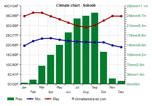
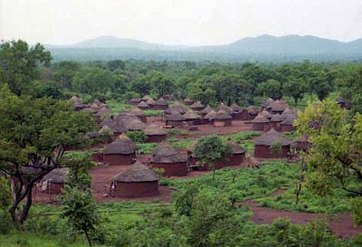
Sokodé, located in the north-central, at 340 meters (1,100 feet) above sea level, highs reach 36.5 °C (97.5 °F) in February and March, while they drop to 29 °C (84 °F) in August.
Precipitation amounts to 1,400 mm (55 in) per year.
The sun often shines from November to February, while in the rainiest period, from July to September, the sky is often cloudy.

In the
center-south, in the Plateaux Region, there are
hilly areas, whose highest point is Mount Agou (or Baumann), 986 meters (3,235 feet) high. Above 500 meters (1,600 feet), during the summer rains, which are also more abundant than at sea level, it can be quite cool.
The coast
Along the
coast, the climate is slightly different. The temperature is more stable, and highs in winter are around 33 °C (91 °F); the warming in spring is not as intense as in the north, then the temperatures drop to 29/30 °C (84/86 °F) from June to September.
In winter, the air is usually humid because of the breeze, but the
Harmattan can sometimes arrive here as well. In summer, the heat is tempered by the wind that blows from the ocean.
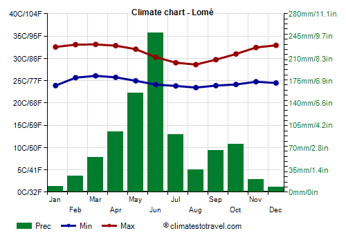
From March to June, the rains increase rapidly, so that June is the rainiest month. But later, unlike in the centre-north, on the coast
the rains decrease, reaching a minimum in August, while they rises again from mid-September to late October, without reaching the values of May and June. However, the sky remains often cloudy and the humidity is high even in August.
Lomé

In the capital,
Lomé, the average daily temperature ranges from 26 °C (79 °F) in August, the coolest month, to 29.5 °C (85 °F) in March, the hottest month.
Owing to the summer break, in Lomé, only 875 mm (34.5 in) of rain fall per year, so the amount of rain that falls on the coast is the lowest of the entire country.
Along the coast, the sun shines quite often in the dry season, however, a bit of cloudiness can form even in this period. From July to September, the sky is often cloudy, even though the rains decrease in this part of the country.
When to go
The best time to visit Togo is the winter, from
November to January: the air is dry and the weather is usually good. It is true that it's hot during the day, especially in the north, but less so than in the following period, from February to May.
The
worst period, being the rainiest, is from May to June on the coast, and from July to September in the interior.
What to pack
In
winter: in Lomé and the coast, pack light clothes for the day, a light sweatshirt for the evening, and a light scarf for the wind full of dust. In the north, pack light clothing, a sweatshirt and a light jacket for the evening, and a light scarf or turban for the desert wind.
In
summer: pack light clothing, made of natural fibers, a light sweatshirt and a light raincoat for the rain showers.
For women, it's better to avoid shorts and miniskirts.
Climate data - Togo
| Atakpamé (400 meters) |
|---|
|
| Jan | Feb | Mar | Apr | May | Jun | Jul | Aug | Sep | Oct | Nov | Dec |
|---|
| Min temp. | 23 | 23 | 23 | 23 | 23 | 22 | 21 | 21 | 21 | 22 | 22 | 22 |
|---|
| Max temp. | 33 | 35 | 35 | 33 | 32 | 30 | 29 | 29 | 30 | 31 | 33 | 33 |
|---|
| Precip. | 10 | 40 | 85 | 125 | 125 | 145 | 120 | 130 | 170 | 110 | 30 | 15 |
|---|
| Prec. days | 0 | 2 | 6 | 8 | 9 | 12 | 13 | 13 | 13 | 10 | 2 | 0 |
|---|
| Humidity | 42% | 54% | 65% | 73% | 76% | 81% | 85% | 86% | 85% | 80% | 68% | 51% |
|---|
| Day length | 12 | 12 | 12 | 12 | 12 | 13 | 12 | 12 | 12 | 12 | 12 | 12 |
|---|
| Sun hours | 7 | 8 | 7 | 7 | 7 | 6 | 4 | 3 | 4 | 7 | 8 | 8 |
|---|
|
| Dapaong (230 meters) |
|---|
|
| Jan | Feb | Mar | Apr | May | Jun | Jul | Aug | Sep | Oct | Nov | Dec |
|---|
| Min temp. | 21 | 23 | 26 | 26 | 25 | 23 | 22 | 22 | 22 | 22 | 22 | 21 |
|---|
| Max temp. | 34 | 36 | 37 | 37 | 35 | 32 | 30 | 29 | 30 | 32 | 36 | 34 |
|---|
| Precip. | 0 | 5 | 15 | 65 | 110 | 150 | 200 | 265 | 200 | 75 | 5 | 0 |
|---|
| Prec. days | 0 | 1 | 2 | 5 | 8 | 11 | 15 | 17 | 15 | 8 | 1 | 0 |
|---|
|
|
|
|
| Kara (340 meters) |
|---|
|
| Jan | Feb | Mar | Apr | May | Jun | Jul | Aug | Sep | Oct | Nov | Dec |
|---|
| Min temp. | 19 | 21 | 24 | 24 | 24 | 22 | 22 | 22 | 21 | 21 | 19 | 18 |
|---|
| Max temp. | 36 | 37 | 38 | 36 | 34 | 32 | 30 | 30 | 31 | 33 | 35 | 36 |
|---|
| Precip. | 5 | 10 | 30 | 75 | 125 | 180 | 205 | 260 | 255 | 135 | 15 | 0 |
|---|
| Prec. days | 0 | 1 | 4 | 8 | 13 | 14 | 18 | 19 | 21 | 12 | 2 | 0 |
|---|
|
|
|
|
| Kuma Konda (640 meters) |
|---|
|
| Jan | Feb | Mar | Apr | May | Jun | Jul | Aug | Sep | Oct | Nov | Dec |
|---|
| Min temp. | 21 | 21 | 21 | 21 | 21 | 20 | 20 | 20 | 20 | 20 | 20 | 21 |
|---|
| Max temp. | 31 | 32 | 31 | 30 | 29 | 27 | 26 | 25 | 26 | 28 | 29 | 30 |
|---|
| Precip. | 20 | 50 | 110 | 130 | 170 | 215 | 190 | 140 | 225 | 195 | 70 | 25 |
|---|
| Prec. days | 2 | 5 | 11 | 11 | 14 | 16 | 18 | 16 | 19 | 16 | 7 | 3 |
|---|
|
|
|
|
| Lomé |
|---|
|
| Jan | Feb | Mar | Apr | May | Jun | Jul | Aug | Sep | Oct | Nov | Dec |
|---|
| Min temp. | 24 | 26 | 26 | 26 | 25 | 24 | 24 | 23 | 24 | 24 | 25 | 24 |
|---|
| Max temp. | 33 | 33 | 33 | 33 | 32 | 30 | 29 | 29 | 30 | 31 | 32 | 33 |
|---|
| Precip. | 10 | 25 | 55 | 95 | 155 | 250 | 90 | 35 | 65 | 75 | 20 | 10 |
|---|
| Prec. days | 0 | 2 | 3 | 5 | 9 | 11 | 6 | 4 | 6 | 6 | 2 | 1 |
|---|
| Humidity | 76% | 79% | 80% | 81% | 83% | 87% | 87% | 87% | 86% | 84% | 82% | 78% |
|---|
| Day length | 12 | 12 | 12 | 12 | 12 | 12 | 12 | 12 | 12 | 12 | 12 | 12 |
|---|
| Sun hours | 7 | 8 | 7 | 7 | 7 | 5 | 5 | 5 | 5 | 7 | 8 | 8 |
|---|
| Sea temp | 28 | 28 | 29 | 29 | 29 | 28 | 26 | 25 | 26 | 27 | 29 | 28 |
|---|
| Mango |
|---|
|
| Jan | Feb | Mar | Apr | May | Jun | Jul | Aug | Sep | Oct | Nov | Dec |
|---|
| Min temp. | 20 | 24 | 27 | 27 | 25 | 24 | 23 | 23 | 23 | 23 | 21 | 20 |
|---|
| Max temp. | 36 | 38 | 40 | 39 | 36 | 34 | 32 | 31 | 32 | 35 | 37 | 36 |
|---|
| Precip. | 0 | 5 | 30 | 65 | 105 | 135 | 195 | 235 | 235 | 70 | 5 | 5 |
|---|
| Prec. days | 0 | 1 | 2 | 4 | 7 | 10 | 12 | 14 | 15 | 6 | 0 | 0 |
|---|
| Humidity | 23% | 25% | 38% | 56% | 68% | 76% | 82% | 85% | 83% | 76% | 51% | 31% |
|---|
| Day length | 12 | 12 | 12 | 12 | 13 | 13 | 13 | 12 | 12 | 12 | 12 | 12 |
|---|
| Sun hours | 9 | 9 | 8 | 8 | 8 | 7 | 5 | 5 | 6 | 8 | 9 | 8 |
|---|
|
| Niamtougou (450 meters) |
|---|
|
| Jan | Feb | Mar | Apr | May | Jun | Jul | Aug | Sep | Oct | Nov | Dec |
|---|
| Min temp. | 20 | 22 | 24 | 24 | 23 | 22 | 21 | 21 | 21 | 21 | 20 | 19 |
|---|
| Max temp. | 34 | 36 | 36 | 35 | 32 | 30 | 29 | 28 | 30 | 32 | 34 | 34 |
|---|
| Precip. | 0 | 10 | 35 | 90 | 165 | 180 | 225 | 250 | 275 | 130 | 25 | 5 |
|---|
| Prec. days | 0 | 1 | 5 | 7 | 8 | 9 | 14 | 16 | 12 | 7 | 2 | 1 |
|---|
| Humidity | 21% | 28% | 43% | 62% | 72% | 77% | 82% | 84% | 82% | 76% | 53% | 30% |
|---|
| Day length | 12 | 12 | 12 | 12 | 13 | 13 | 13 | 12 | 12 | 12 | 12 | 12 |
|---|
|
|
| Sokodé (400 meters) |
|---|
|
| Jan | Feb | Mar | Apr | May | Jun | Jul | Aug | Sep | Oct | Nov | Dec |
|---|
| Min temp. | 20 | 22 | 23 | 24 | 23 | 22 | 22 | 22 | 21 | 21 | 20 | 19 |
|---|
| Max temp. | 35 | 37 | 37 | 35 | 33 | 31 | 30 | 29 | 30 | 33 | 35 | 35 |
|---|
| Precip. | 5 | 15 | 65 | 105 | 140 | 185 | 235 | 245 | 255 | 115 | 20 | 10 |
|---|
| Prec. days | 0 | 1 | 5 | 8 | 11 | 13 | 16 | 18 | 16 | 8 | 1 | 1 |
|---|
| Humidity | 33% | 40% | 55% | 70% | 76% | 81% | 85% | 86% | 86% | 79% | 62% | 43% |
|---|
| Day length | 12 | 12 | 12 | 12 | 12 | 13 | 13 | 12 | 12 | 12 | 12 | 12 |
|---|
| Sun hours | 8 | 9 | 8 | 7 | 7 | 6 | 4 | 4 | 5 | 7 | 8 | 8 |
|---|
|
| Tabligbo |
|---|
|
| Jan | Feb | Mar | Apr | May | Jun | Jul | Aug | Sep | Oct | Nov | Dec |
|---|
| Min temp. | 22 | 24 | 24 | 24 | 24 | 23 | 23 | 22 | 23 | 23 | 23 | 22 |
|---|
| Max temp. | 35 | 36 | 36 | 35 | 34 | 32 | 31 | 30 | 32 | 33 | 34 | 35 |
|---|
| Precip. | 5 | 25 | 100 | 115 | 150 | 165 | 100 | 50 | 120 | 150 | 50 | 10 |
|---|
| Prec. days | 1 | 3 | 7 | 8 | 11 | 13 | 10 | 8 | 12 | 14 | 6 | 2 |
|---|
|
|
|
|
See also the
temperatures month by month