Select units of measurement for the temperature and rainfall tables (metric or imperial).
Average weather, temperature, rainfall, sunshine
In Eswatini (known as Swaziland before 2018), a small country bordering South Africa and Mozambique, mountainous in the west and hilly in the east, the climate varies mainly with
altitude.
Throughout the country, there is a
rainy season from mid-October to mid-April and a
dry season from mid-April to mid-October, but in the western area, where the altitude is higher, rainfall is more abundant. The rains occur primarily as showers or thunderstorms in the afternoon.
The austral
winter, from May to August, is dry and sunny everywhere, with cold nights. During the day, on the other hand, it can get very hot in the austral
summer, but especially from September to November.
The altitude determines
three areas with different climates and environments: Highveld, Middle Veld and Lowveld.
The climate in detail
Highveld
In the west, we find the
Highveld, crossed by the Drakensberg Mountains, at an altitude between 800 and 1,800 meters (2,600 and 6,000 ft). Here, the climate is temperate, with cold nights in winter. Being that it's a humid area, we find forests, rivers and waterfalls.
In summer, it can sometimes get hot during the day, but nights remain cool, while in winter, the night temperature can drop below freezing (0 °C or 32 °F).
The rainfall amounts to 1,000/2,000 millimeters (40/80 inches) per year.
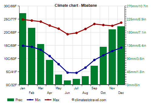
Mbabane

The capital,
Mbabane, is situated in this area, at 1,200 meters (3,900 feet) above sea level. The maximum temperatures range from around 25 °C (77 °F) in January and February, to 19/20°C (66/68 °F) in June and July.
In Mbabane, 1,350 mm (53 in) of rain fall per year, with a maximum in summer (from November to February) and a minimum in winter, when the rains are rare.
In Mbabane, and in Eswatini in general, the sun shines all year round, but especially in the dry season, while in the rainy season, the hours of sunshine decrease a little.
Middle Veld
The
Middle Veld lies in the center of the country, between 400 and 800 meters (1,300 and 2,600 feet) above sea level. Here, the temperature is slightly higher: in winter, the weather is pleasant during the day, it gets cold at night but the risk of frost is lower. On the contrary, summer is hot, sometimes very hot, with peaks near 40 °C (104 °F).
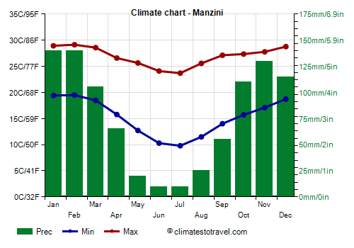
Manzini

In
Manzini, the second city of the country, highs reaches 29 °C (84 °F) in January and February, while they drop to 23.5/24 °C (74/75 °F) in June and July.
The rainfall pattern in Manzini is the same as that of Mbabane, with a summer maximum and a winter minimum, but the amount is lower, around 920 mm (36 in) per year.
Lowveld
The
Lowveld is found in the east, between 100 and 400 meters (350 and 1,300 feet), and it's characterized by a warmer climate and a landscape dominated by the savannah. During winter, nights can be cold, with a wide daily temperature range. Summer is humid and uncomfortably hot. Rainfall in the Lowveld is even lower, and amounts to around 500/900 mm (20/35 in) per year.
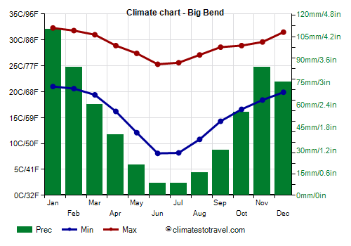
Big Bend

In
Big Bend, a town in the east of the country, at 100 meters (350 ft) above sea level, highs reaches 32 °C (89.5 °F) in January and February, while they drop to 25.5/26 °C (78/79 °F) in June and July.
In Big Bend, rainfall amounts to 600 mm (23.5 in) per year.
In the easternmost area, the altitude increases slightly again, in the Lebombo Mountains, which despite their name do not reach 800 meters (2,600 feet).

Tropical cyclones
Occasionally, Eswatini can be affected by
tropical cyclones coming from the Indian Ocean (which lies to the east, beyond the border with Mozambique and South Africa), as happened with Tropical Storm Domoina in late January 1984. The cyclone season in the Southern Hemisphere runs from November to mid-May, but they are most likely from late December to mid-April.
When to go
The best time to visit Eswatini is from
June to September, since it is the coolest and driest period of the year, and outside the cyclone season.
However, it is winter, so it can get cold at night even in the Lowveld, and even more so in the Highveld, where the night temperature can drop below freezing from May to August.
In September, it is less cold in the mountains, but it can be very hot at medium and low altitudes.
What to pack
In
winter (June to August): for the Highveld and Mbabane, pack spring/autumn clothes for the day, but also a sweater and a jacket for the evening, and hiking shoes. For the Middle Veld, pack spring/autumn clothes. For the Lowveld, pack light clothes for the day, a jacket and a sweater for the evening and the early hours of the morning.
In
summer (December to February): for the Highveld and Mbabane, pack light clothes for the day, a sweater and a sweatshirt or a jacket for the evening, a sun hat, an umbrella or a light raincoat, and hiking shoes. For the Middle Veld, light clothes for the day, a light sweatshirt and a light jacket for the evening. For the Lowveld, light clothing, a light raincoat or umbrella, and a light sweatshirt for the evening.
Climate data - Swaziland
| Big Bend |
|---|
|
| Jan | Feb | Mar | Apr | May | Jun | Jul | Aug | Sep | Oct | Nov | Dec |
|---|
| Min temp. | 21 | 21 | 19 | 16 | 12 | 8 | 8 | 11 | 14 | 17 | 18 | 20 |
|---|
| Max temp. | 32 | 32 | 31 | 29 | 27 | 25 | 26 | 27 | 29 | 29 | 30 | 32 |
|---|
| Precip. | 110 | 85 | 60 | 40 | 20 | 10 | 10 | 15 | 30 | 55 | 85 | 75 |
|---|
| Prec. days | 8 | 7 | 7 | 5 | 3 | 2 | 1 | 2 | 4 | 6 | 10 | 7 |
|---|
|
| Day length | 14 | 13 | 12 | 11 | 11 | 10 | 11 | 11 | 12 | 13 | 14 | 14 |
|---|
|
|
| Manzini (600 meters) |
|---|
|
| Jan | Feb | Mar | Apr | May | Jun | Jul | Aug | Sep | Oct | Nov | Dec |
|---|
| Min temp. | 19 | 20 | 18 | 16 | 13 | 10 | 10 | 12 | 14 | 16 | 17 | 19 |
|---|
| Max temp. | 29 | 29 | 29 | 27 | 26 | 24 | 24 | 26 | 27 | 27 | 28 | 29 |
|---|
| Precip. | 140 | 140 | 105 | 65 | 20 | 10 | 10 | 25 | 55 | 110 | 130 | 115 |
|---|
| Prec. days | 12 | 8 | 9 | 6 | 3 | 1 | 2 | 4 | 6 | 9 | 13 | 11 |
|---|
| Humidity | 70% | 69% | 68% | 66% | 56% | 50% | 50% | 49% | 55% | 63% | 67% | 70% |
|---|
| Day length | 14 | 13 | 12 | 11 | 11 | 10 | 11 | 11 | 12 | 13 | 13 | 14 |
|---|
|
|
| Mbabane (1,200 meters) |
|---|
|
| Jan | Feb | Mar | Apr | May | Jun | Jul | Aug | Sep | Oct | Nov | Dec |
|---|
| Min temp. | 15 | 14 | 13 | 11 | 8 | 5 | 5 | 7 | 10 | 11 | 13 | 14 |
|---|
| Max temp. | 25 | 24 | 24 | 23 | 21 | 19 | 20 | 21 | 23 | 23 | 22 | 24 |
|---|
| Precip. | 245 | 195 | 140 | 85 | 35 | 15 | 20 | 30 | 65 | 130 | 190 | 200 |
|---|
| Prec. days | 13 | 11 | 10 | 7 | 4 | 2 | 2 | 3 | 6 | 10 | 14 | 13 |
|---|
|
| Day length | 14 | 13 | 12 | 11 | 11 | 10 | 11 | 11 | 12 | 13 | 13 | 14 |
|---|
| Sun hours | 6 | 6 | 6 | 7 | 7 | 8 | 8 | 8 | 7 | 6 | 5 | 5 |
|---|
|
See also the
temperatures month by month