Select units of measurement for the temperature and rainfall tables (metric or imperial).
Average weather, temperature, rainfall, sunshine
In Panama, the climate is
equatorial, hot and rainy all year round, on the north coast, facing the Caribbean Sea. On the southern side, overlooking the Pacific Ocean, the climate is
tropical, hot all year round, but with a rainy season from May to November and a dry season from December to April.
Panama is a Central American country located just north of the Equator.
The climate in detail
The seasons
As mentioned, since it is hot all year round, the main difference is found in the
rains.
From
May to November, the north-east trade wind meets the southwestern currents of equatorial origin, and it rains all over the country, even on the southern side exposed to the Pacific Ocean, so this is the
rainy season.
In contrast, from
December to April, the northeastern trade winds prevail, which bring abundant rainfall on the north side overlooking the Caribbean Sea, especially in the first part (December-January), that is to say, when the sea is warmer, while on the south side, beyond the mountain ranges that stretch across the interior of the country as a backbone, this is the
dry season.
The rains mostly occur in the form of heavy downpours or thunderstorms (called
aguaceros), usually in the afternoon or evening, but they can continue even in the early hours of the night.
However, there are some
variations from one year to the next, which make the weather quite unpredictable, especially on the north side, while on the southern side, the seasons are more defined.
On the north side,
temperatures vary little throughout the year, and the humidity is stably high. The south side is warmer than the north side, moreover, the coolest months, or rather the least hot, are usually October and November, at the end of the rainy season, although the humidity during this period makes the heat unpleasant. The hottest months are usually March and April, before the rainy season.
The amount of
sunshine in Panama is not great, in fact, some cloudiness can always form, however, it's better at the height of the dry season, from February to April. On the other hand, even in the rainy season, the sun makes its appearance for a few hours a day on average, at least in the plains and along the coasts. The cloudiest areas are the east, towards the border with Colombia, and the mountainous inland areas.
North-west
In the north-west, the province of Bocas del Toro has an
equatorial climate, ie with no dry season.
Near the border with Costa Rica, the northern side of the mountain range called
Cordillera de Talamanca, where the Amistad International Park is found, is occupied by a cloud forest.
In this zone (see Changuinola and the Bocas del Toro Archipelago), where more than 3,000 millimeters (118 inches) of rain fall per year, there are two periods when there's a relative decline in rainfall: February-March and (a little less) September-October, while the wettest months are July, August, November and December.
Bocas Town

Temperatures on the Caribbean side are not too high, even though the air is humid. In Bocas del Toro, or Bocas Town, located on Colón Island, which is part of the Bocas del Toro archipelago, the average temperature ranges from 26 °C (78 °F) in December to 28 °C (82.5 °F) in May and June.
In this zone, the period of the northeastern trade winds, though rainy, is quite sunny, especially in February and March, when the rains become a little less frequent.
On the north side of Panama, the sea is warm all year round.
Apart from to the northwest, there are other areas of Panama that have an equatorial climate: the northern slopes of the highest mountains, and, in the south-east, the interior of the
Darién Province, on the border with Colombia, where an impenetrable rainforest grows, so much so that even the Pan-American Highway, which otherwise would connect the whole American continent from Alaska to Patagonia, is interrupted south of Yaviza (the interruption is called "Darién Gap"). In this area, more than 3,000 mm (118 in) of rain fall per year, and the only time when precipitation goes down to around 150 mm (6 in) per month is January to March.
North side
In the rest of the coast overlooking the Caribbean Sea, it rains more than on the southern side, there is a
decrease in rainfall from January to April, which is more pronounced than in the northwest.
Colón

In Colón, near the Caribbean entrance to the Panama Canal, rainfall amounts to 3,300 mm (130 in) per year. In the wettest month, November, the rains become monsoon-like, reaching as high as 550 mm (21.5 in) in a month.
North-east of Colón, we find the
San Blas archipelago, made up of coral islands which are inhabited by the Kuna Indians.
South side
The southern side, being leeward from the trade winds, is
a bit hotter and less rainy than the northern side.
Panama City
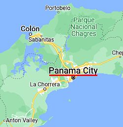 Panama City, where is located

In
Panama City, the capital, located on the south coast, at 9 degrees north latitude, the monthly average temperature ranges from 27 °C (80.5 °F) in October and November to 28.5 °C (83 °F) in April. The January-April period is the hottest, driest and sunniest of the year, although the humidity is lower than in the rainy period. The hottest months are March and April.
In Panama city, rainfall amounts to about 1,900 mm (75 in) per year, almost all of it falling in the rainy season, from May to mid-December. This period is also characterized by hot and muggy weather, with poor sunshine.
In the south side of Panama too, the
sea is warm enough for swimming all year round: the water temperature ranges from 26.5 °C to 28.5 °C (80 °F to 83 °F).

The south-west

In the southern plain to the west of the Gulf of Panana (see David, Santiago) and in the Azuero Peninsula, the rainfall drops below 100 mm (4 in) already in December. During the dry season, the sun shines along the coast and it is
very hot in the interior, with highs around 35 °C (95 °F).
Santiago de Veraguas

In Santiago de Veraguas, in the inland plain, on the hottest days, which generally occur from February to April, the temperature reaches 36/37 °C (97/99 °F), but can sometimes reach 38/39 °C (100/102 °F), especially in El Niño years, such as 1998 and 2016.
In Santiago de Veraguas, almost 2,500 mm (98 in) of rain fall per year.
South of the coast, we find the pristine island of
Coiba, which is home to a national park, and is also a UNESCO World Heritage Site.
In the
southern provinces of Herrera, Coclé and Los Santos, in the part overlooking the
Gulf of Panama (see Anton, Chitré, in the small area circled in light red), precipitation drops to around 1,500 millimeters (60 inches) per year. In this region, the vegetation is less thick, in fact, there are also grasslands and shrubs.
In the interior, in the
Sarigua National Park, there is even a desert, actually due to deforestation occurred during the last century to make room for grazing, rather than to the climate.
Hills and mountains
To find a bit of cool weather, you have to climb above 1,000 meters (3,300 feet), in the so-called
tierras templadas ("temperate lands"), which have a milder climate.
Boquete

In
Boquete, 1,200 meters (3,900 feet) above sea level, on the slopes of Barú volcano, which is the highest peak in Panama with its 3,475 meters (11,401 feet), the average temperature hovers between 19 °C and 20.5 °C (66 °F and 69 °F) throughout the year.
In Boquete, 3,200 mm (125 in) of rain fall per year; rainfall exceeds 300 mm (12 in) from May to November, while it drops below 100 mm (4 in) per month from January to March.
Above 2,000 meters (6,500 feet), in the
tierras frías ("cold lands"), nights can be cold, especially during the period from December to March. Above 3,000 meters (10,000 ft), it can get cold even during the day.
Hurricanes
Panama is
almost always spared from hurricanes, which pass through the Caribbean Sea and Central America at a higher latitude.
The only hurricane that hit Panama in historical times was Martha, which followed an abnormal trajectory (from north to south) and hit the coast in Mosquito Gulf, in November 1969. More recently, two hurricanes, Otto in November 2016 and Nate in November 2017, have affected Panama, even though they affected the Caribbean Sea more to the north.
However, the hurricane season runs from June to November, even though at such a low latitude they almost always form at the end of the period, that is, in October and November.
When to go
The best time to visit Panama as a whole runs from
February to April, and in particular, the months of February and March: it's hot almost everywhere, the sun shines and there is little rain, except on the north-west and in the interior of the Darién province, where rainfall is quite frequent even during this period.
On the
southern side, overlooking the Pacific Ocean, you can go from
December to April, with a preference for December and January because from February to April it is very hot, especially in inland areas.
What to pack
For
plains and coasts: bring lightweight clothes, and a light sweatshirt for the evening and for air conditioning. In the rainy season (from May to mid-December in Panama City, and throughout the year in the areas having an equatorial climate), you can add a light raincoat or umbrella. When going to the reef, you can bring snorkeling equipment, including water shoes or rubber-soled shoes.
For the
tierras templadas: all year round, bring light clothing, and a sweatshirt or sweater for the evening; a raincoat or umbrella in the rainy season. In the dry season, sunscreen and a sun hat.
For the
tierras frías: throughout the year, bring clothes for spring and autumn, a T-shirt for the day, and a sweater or sweatshirt and a jacket for the evening; a raincoat or umbrella in the rainy season.
For
high mountains: bring warm clothes, a jacket, and hiking boots.
Climate data - Panama
| Anton |
|---|
|
| Jan | Feb | Mar | Apr | May | Jun | Jul | Aug | Sep | Oct | Nov | Dec |
|---|
| Min temp. | 21 | 22 | 22 | 22 | 22 | 22 | 21 | 21 | 21 | 21 | 21 | 22 |
|---|
| Max temp. | 33 | 34 | 35 | 35 | 35 | 34 | 33 | 34 | 33 | 33 | 33 | 33 |
|---|
| Precip. | 30 | 5 | 5 | 40 | 170 | 190 | 170 | 195 | 215 | 255 | 215 | 90 |
|---|
| Prec. days | 2 | 1 | 1 | 3 | 12 | 14 | 13 | 15 | 15 | 18 | 15 | 6 |
|---|
|
|
|
|
| Bocas Town |
|---|
|
| Jan | Feb | Mar | Apr | May | Jun | Jul | Aug | Sep | Oct | Nov | Dec |
|---|
| Min temp. | 24 | 24 | 24 | 25 | 25 | 25 | 25 | 25 | 25 | 25 | 24 | 23 |
|---|
| Max temp. | 30 | 30 | 30 | 30 | 31 | 31 | 30 | 30 | 30 | 29 | 29 | 28 |
|---|
| Precip. | 245 | 190 | 180 | 280 | 325 | 280 | 380 | 330 | 195 | 215 | 335 | 390 |
|---|
|
|
|
| Sun hours | 7 | 8 | 9 | 8 | 8 | 7 | 7 | 6 | 6 | 6 | 6 | 7 |
|---|
| Sea temp | 28 | 28 | 28 | 29 | 29 | 29 | 29 | 29 | 29 | 29 | 28 | 28 |
|---|
| Boquete (1,200 meters) |
|---|
|
| Jan | Feb | Mar | Apr | May | Jun | Jul | Aug | Sep | Oct | Nov | Dec |
|---|
| Min temp. | 16 | 15 | 16 | 16 | 17 | 17 | 17 | 17 | 17 | 16 | 16 | 16 |
|---|
| Max temp. | 23 | 23 | 24 | 24 | 24 | 24 | 24 | 24 | 23 | 24 | 23 | 23 |
|---|
| Precip. | 80 | 70 | 90 | 225 | 425 | 345 | 240 | 320 | 395 | 525 | 370 | 160 |
|---|
| Prec. days | 13 | 10 | 9 | 11 | 20 | 22 | 23 | 24 | 22 | 23 | 21 | 18 |
|---|
|
|
|
|
| Chitré |
|---|
|
| Jan | Feb | Mar | Apr | May | Jun | Jul | Aug | Sep | Oct | Nov | Dec |
|---|
| Min temp. | 19 | 19 | 20 | 21 | 22 | 22 | 21 | 21 | 21 | 21 | 20 | 20 |
|---|
| Max temp. | 34 | 34 | 35 | 35 | 35 | 34 | 34 | 34 | 34 | 34 | 34 | 33 |
|---|
| Precip. | 10 | 0 | 5 | 20 | 110 | 135 | 95 | 125 | 160 | 225 | 125 | 45 |
|---|
| Prec. days | 1 | 0 | 0 | 2 | 8 | 12 | 9 | 10 | 13 | 14 | 10 | 4 |
|---|
|
|
|
|
| Colón |
|---|
|
| Jan | Feb | Mar | Apr | May | Jun | Jul | Aug | Sep | Oct | Nov | Dec |
|---|
| Min temp. | 23 | 23 | 24 | 25 | 24 | 24 | 24 | 24 | 23 | 23 | 23 | 23 |
|---|
| Max temp. | 29 | 29 | 30 | 31 | 30 | 30 | 30 | 29 | 29 | 29 | 29 | 28 |
|---|
| Precip. | 95 | 50 | 45 | 125 | 360 | 340 | 380 | 360 | 310 | 395 | 550 | 340 |
|---|
| Prec. days | 9 | 7 | 7 | 9 | 19 | 20 | 22 | 23 | 19 | 22 | 24 | 17 |
|---|
|
|
|
|
| David |
|---|
|
| Jan | Feb | Mar | Apr | May | Jun | Jul | Aug | Sep | Oct | Nov | Dec |
|---|
| Min temp. | 22 | 23 | 23 | 23 | 23 | 23 | 23 | 23 | 23 | 23 | 23 | 22 |
|---|
| Max temp. | 33 | 34 | 35 | 34 | 32 | 31 | 31 | 31 | 31 | 30 | 30 | 31 |
|---|
| Precip. | 35 | 20 | 35 | 100 | 295 | 325 | 290 | 340 | 405 | 400 | 295 | 75 |
|---|
|
|
|
| Sun hours | 9 | 9 | 9 | 7 | 5 | 4 | 5 | 5 | 5 | 4 | 5 | 7 |
|---|
|
| Panama City |
|---|
|
| Jan | Feb | Mar | Apr | May | Jun | Jul | Aug | Sep | Oct | Nov | Dec |
|---|
| Min temp. | 22 | 22 | 23 | 23 | 24 | 24 | 24 | 24 | 24 | 24 | 23 | 23 |
|---|
| Max temp. | 33 | 33 | 33 | 33 | 32 | 31 | 32 | 32 | 31 | 31 | 31 | 32 |
|---|
| Precip. | 30 | 10 | 15 | 65 | 225 | 235 | 170 | 220 | 255 | 330 | 250 | 105 |
|---|
| Prec. days | 3 | 1 | 1 | 5 | 15 | 16 | 14 | 15 | 17 | 20 | 16 | 8 |
|---|
|
|
| Sun hours | 7 | 8 | 8 | 7 | 7 | 6 | 6 | 6 | 6 | 5 | 6 | 6 |
|---|
| Sea temp | 27 | 27 | 26 | 27 | 28 | 29 | 28 | 29 | 29 | 29 | 28 | 28 |
|---|
| Santiago |
|---|
|
| Jan | Feb | Mar | Apr | May | Jun | Jul | Aug | Sep | Oct | Nov | Dec |
|---|
| Min temp. | 20 | 21 | 21 | 22 | 23 | 23 | 23 | 23 | 22 | 22 | 22 | 22 |
|---|
| Max temp. | 33 | 34 | 35 | 35 | 33 | 32 | 32 | 32 | 32 | 31 | 31 | 32 |
|---|
| Precip. | 30 | 20 | 10 | 100 | 340 | 290 | 230 | 360 | 350 | 410 | 260 | 70 |
|---|
| Prec. days | 3 | 1 | 2 | 5 | 15 | 16 | 14 | 15 | 17 | 18 | 17 | 8 |
|---|
|
|
|
|
See also the
temperatures month by month