Select units of measurement for the temperature and rainfall tables (metric or imperial).
Average weather, temperature, rainfall, sunshine hours
Introduction
In Veneto, a region of northeastern Italy, we have the following types of climate:
- In the north, the cold mountain climate of the
Alps and the temperate humid climate of the
Pre-Alps.
- In the central-southern part, the semi-continental climate of the
Venetian plain.
The Venetian plain overlooks the upper Adriatic, a narrow and shallow sea that does not mitigate the climate much, however, it is a little milder than the Po valley, also because it is exposed to the
scirocco, the warm wind from the southeast. However, on this plain, the
bora, the cold wind from Eastern Europe, can blow as well.
The
Po river flows in the southern part (in the area called Polesine) and marks the border with Emilia-Romagna, until it widens into a delta.
Precipitation is more abundant in the mountains than in the plains. In the Pre-Alps it is particularly abundant, ranging from 1,100 to 2,200 millimeters (43.5 to 86.5 inches) per year. In the Alps, it generally ranges from 1,100 to 1,500 mm (43.5 to 59 in). In the plains, it amounts to 1,100 mm (43.5 in) per year in the area close to the Pre-Alps, it ranges between 750 and 900 mm (29.5 to 35.5 in) in most of the territory, while it drops below 600 mm (23.5 in) in the south, in the province of Rovigo.
Winter is usually the driest season.
In spring and summer, from May to August,
thunderstorms can occur, sometimes intense and accompanied by hail, especially in the area near the Pre-Alps, including
Lake Garda, located in the western part and shared with Lombardy, where there is a mild microclimate.
In autumn there can be
waves of bad weather, with the sirocco from the Adriatic meeting the mountains. Sometimes, the rivers that descend from the mountains (Piave, Brenta, Adige, Bacchiglione) can overflow, as happened in early November 1966, in early November 2010 and in late October 2018.
Alps and Prealps
The northern part of Veneto is occupied by mountains.
To the east of Lake Garda we have the Garda Prealps, further east we have the Venetian Prealps, while to the north we find the
South-Eastern Alps, and in particular, the Venetian part of the
Dolomites.
North of Belluno we find the Belluno Dolomites National Park, a UNESCO World Heritage Site in 2009.
The highest peak in Veneto is Punta Penia, 3,343 meters (10,968 feet) high and belonging to the Marmolada. In this mountain we also find a glacier, the largest in the Dolomites, which however is located in the province of Trento.
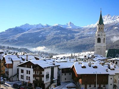
 Cortina d'Ampezzo
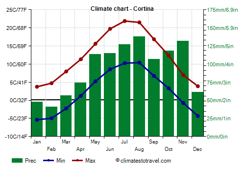
 is located in the province of Belluno, at an altitude of 1,230 metres (4,035 ft). The average temperature ranges from -1 °C (30 °F) in January to 16 °C (61 °F) in July and August. Precipitation amounts to 1,100 millimeters (43 in) per year. On average, more than two meters (78.5 in) of snow fall per year. In winter, during cold spells, the temperature can drop to -18/-20 °C (-4/0 °F), while in summer, on the hottest days, it can reach 28/30 °C (82/86 °F). Here are the average temperatures.
Cortina - Average temperatures (1992-2020) |
| Month | Min | Max | Mean |
|---|
| January | -5.4 | 3.8 | -0.8 |
|---|
| February | -4.9 | 4.7 | -0.1 |
|---|
| March | -2.2 | 8 | 2.9 |
|---|
| April | 1.2 | 11.4 | 6.3 |
|---|
| May | 5.3 | 15.6 | 10.4 |
|---|
| June | 8.6 | 19.7 | 14.2 |
|---|
| July | 10.3 | 21.9 | 16.1 |
|---|
| August | 10.4 | 21.5 | 16 |
|---|
| September | 6.7 | 16.9 | 11.8 |
|---|
| October | 3.4 | 12.4 | 7.9 |
|---|
| November | -0.7 | 7 | 3.1 |
|---|
| December | -4.3 | 3.9 | -0.2 |
|---|
| Year | 2.4 | 12.3 | 7.3 |
|---|

Plain
In the plain of Veneto, there is a
moderately continental climate, with cold, damp winters and hot, muggy summers. The average temperatures in January are generally 3/3.5 °C (37.5/38.5 °F) in inland areas, and reach up to 4 °C (39 °F) on the coast.

For example, in
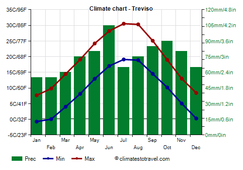
Treviso, a city located 20 km (12 mi) north of Venice, the average temperature ranges from 3.5 °C (38.5 °F) in January to 25 °C (77 °F) in July. Precipitation amounts to 895 mm (35 in) per year. Here are the average temperatures.
Treviso - Average temperatures (1991-2020) |
| Month | Min | Max | Mean |
|---|
| January | -0.7 | 7.7 | 3.5 |
|---|
| February | 0.1 | 9.8 | 4.9 |
|---|
| March | 4 | 14.5 | 9.3 |
|---|
| April | 8.1 | 19.1 | 13.6 |
|---|
| May | 12.9 | 24.2 | 18.6 |
|---|
| June | 17 | 28.2 | 22.6 |
|---|
| July | 19.1 | 30.5 | 24.8 |
|---|
| August | 18.9 | 30.3 | 24.6 |
|---|
| September | 14.5 | 25.1 | 19.8 |
|---|
| October | 10.2 | 19 | 14.6 |
|---|
| November | 5 | 13 | 9 |
|---|
| December | 0.3 | 8.4 | 4.3 |
|---|
| Year | 9.2 | 19.2 | 14.15 |
|---|
On the
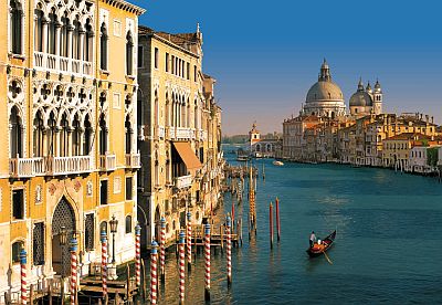
coast, the climate is a little milder. The regional capital,
Venice, is located on islands in the Venetian lagoon, while Mestre and Marghera are on the mainland.

The
sea, in the Venetian lagoon, but also along the coast of the Northern Adriatic Sea (see Jesolo), is warm enough for swimming in July and August, but all in all also in September, while it is still a bit cool in June. Here is the average sea temperature in Venice.
Venice - Sea temperature| Month |
|---|
| January | 11.5 |
|---|
| February | 10 |
|---|
| March | 10.5 |
|---|
| April | 13.5 |
|---|
| May | 18 |
|---|
| June | 22.5 |
|---|
| July | 25.5 |
|---|
| August | 26 |
|---|
| September | 23 |
|---|
| October | 19.5 |
|---|
| November | 16.5"> |
|---|
| December | 13.5 |
|---|
| Year | 17.6 |
|---|
in the north-eastern plains (Veneto and Friuli-Venezia Giulia) is rarer than in the other northern Italian regions (Lombardy, Piedmont and Emilia-Romagna), because the Veneto plain is smaller and it cools down less, moreover, as mentioned, it can receive the sirocco. During cold spells, the Venetian plain is swept by the bora, which is originally a dry wind.
The least snowy area is that of the Po delta, occupied by water and surrounded by the sea. Even in the area south of Lake Garda and in Verona, it snows quite rarely. The snowiest cities in the plain are those furthest from the coast and closest to the Pre-Alps (see Vicenza, Thiene), where in any case, about 15 cm (6 in) of snow fall per year.
Every now and then,
cold air masses from Eastern Europe can bring quite intense frosts, though the temperature rarely drops below -10 °C (14 °F). In the past, however, during the most intense cold spells, such as in 1929, 1956 and 1985, temperatures of -15 °C (5 °F), and locally even -20 °C (-4 °F) were reached in the Venetian plains.
Summer, from June to August, is hot and muggy, and generally sunny, at least in the morning. The average temperature in July and August is fairly uniform, around 24 °C (75 °F) on the coast and around 24.5 °C (76 °F) in inland areas.
Sometimes, an Atlantic front, able to bring cool and rainy weather, can affect this area even in summer; more often, as mentioned, on sunny days, thunderstorms can erupt in the afternoon or evening, especially in the northern part, the one closest to the Prealps.
During
heat waves, which are becoming increasingly more frequent, the temperature can reach or exceed 35 °C (95 °F). The heat records are around 39-40 °C (102-104 °F) in the cities located at some distance from the coast.
Best Time
The best period to visit the
cities of Veneto is that of spring and early summer, and in particular, from mid-April to mid-June. September, too, is a good month. However, you have to take into account some rainy days in both periods.
Summer can be hot, although some days can be acceptable, especially in June. In summer, and sometimes in May, sudden thunderstorms in the afternoon or evening must be put into account.
You can go to the
Dolomites either in winter, perhaps for skiing, and in summer, perhaps for trekking in the mountains and to escape the heat of the plains.
For a
beach holiday along the coast of Veneto, the best period is the summer, particularly in July and August, since they are the hottest and sunniest months, and in which the sea is warmest as well.
See also the
temperatures by month.