Select units of measurement for the temperature and rainfall tables (metric or imperial).
Average weather, temperature, rainfall, sunshine hours
Umbria is a small region of central Italy, without access to the sea, crossed by the Umbria-Marche Apennines in the eastern part, and occupied by valleys and hills in the central-western part.
The climate varies mainly according to the altitude, and is practically
Mediterranean il the lowlands, while it gradually becomes more continental and colder as the altitude increases.
In winter,
fog can form in periods of stable weather, or the
tramontana, the cold north wind, can blow on other occasions.
In summer it is
very hot during the day, with peaks as high as 40 °C (104 °F) at low altitudes, but at night the temperature drops a lot, and it can get cool at hill altitudes.
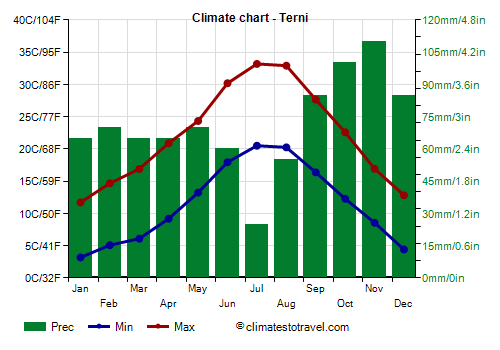
Precipitation is moderate, as it is generally between 700 and 1,100 millimeters (27 and 43 inches) per year. The rainiest season is autumn, when sometimes, usually in November but sometimes also in December, the Tiber river or one of its tributaries can overflow. The driest season is summer, when the weather is often good, though thunderstorms can break out in the afternoon.
Snowfalls are rare at low altitudes, while they become more frequent and abundant as the altitude increases.
Plains and hills
At
lower altitudes, below 200 metres (650 feet, see Terni, Orvieto Scalo, Narni Scalo, Attigliano), winter is quite mild, while summer is particularly hot. There are periods, even quite long, with oppressive heat during the day, given the distance from the sea.

In
Terni, located at an altitude of 130 metres (425 ft), in recent years, the average maximum temperature in July and August has been of 33 °C (91.5 °F). Here are the average temperatures.
Terni - Average temperatures (2014-2022) |
| Month | Min | Max | Mean |
|---|
| January | 3.2 | 11.7 | 7.4 |
|---|
| February | 5.1 | 14.7 | 9.9 |
|---|
| March | 6.1 | 16.9 | 11.5 |
|---|
| April | 9.2 | 20.9 | 15 |
|---|
| May | 13.2 | 24.3 | 18.8 |
|---|
| June | 17.9 | 30.2 | 24.1 |
|---|
| July | 20.5 | 33.2 | 26.8 |
|---|
| August | 20.2 | 32.9 | 26.6 |
|---|
| September | 16.4 | 27.7 | 22 |
|---|
| October | 12.3 | 22.6 | 17.4 |
|---|
| November | 8.6 | 16.9 | 12.7 |
|---|
| December | 4.4 | 12.8 | 8.6 |
|---|
| Year | 11.5 | 22.1 | 16.75 |
|---|
Foligno, the third largest city in Umbria, is located 235 meters (770 ft) above sea level.
In the north-west of the region we find
Lake Trasimeno, whose shores are at an altitude of 260 metres (855 ft). The main localities are Castiglione del Lago and Passignano sul Trasimeno.
The cities of Umbria are often located on
hills, so the altitude varies according to the areas. The capital of the region,
Perugia, is located at a variable altitude between 300 and 493 meters (985 and 1,617 ft), where the historic center is located.
Other cities that are located at an altitude of between 300 and 500 meters are Città di Castello, Orvieto, Spoleto, Assisi, Nocera Umbra, Città della Pieve, and Gubbio.
At this altitude, the climate is
temperate, but with slightly continental characteristics. In winter it can get cold and sometimes it can snow, while in summer it can get very hot.

Above 500 metres (1,650 ft), in winter, snowfalls become quite frequent during cold air irruptions, and can sometimes be abundant. In summer, it can get very hot during the day, but nights are usually cool, and sometimes very cool.
In
Norcia, located 600 meters (1,970 ft) above sea level, temperatures are similar to those of L'Aquila, in Abruzzo. Here, the temperature dropped to -15 °C (5 °F) in February 2018, while it reached 39 °C (102 °F) in August 2017 and at the end of June 2022.
Norcia - Average temperatures (2010-2020) |
| Month | Min | Max | Mean |
|---|
| January | -1.9 | 8.4 | 3.3 |
|---|
| February | -1 | 10.6 | 4.8 |
|---|
| March | 1.1 | 13.8 | 7.5 |
|---|
| April | 4.4 | 18.2 | 11.3 |
|---|
| May | 7.5 | 20.8 | 14.1 |
|---|
| June | 11.2 | 26.6 | 18.9 |
|---|
| July | 13.5 | 29.8 | 21.6 |
|---|
| August | 13.4 | 30.4 | 21.9 |
|---|
| September | 10.2 | 24.5 | 17.4 |
|---|
| October | 6.7 | 19.6 | 13.1 |
|---|
| November | 3.5 | 14 | 8.8 |
|---|
| December | -1 | 9.1 | 4 |
|---|
| Year | 5.7 | 18.9 | 12.25 |
|---|
In
Monteleone di Spoleto, the highest municipality in Umbria, located at 980 meters (3,215 ft) above sea level, the average temperature ranges from 2 °C (35.5 °F) in January to 20 °C (68 °F) in July and August. Here, the temperature dropped to -19.5 °C (-3 °F) in February 2018, while it reached 38.3 °C (101 °F) in August 2017.
Mountains
Above 1,000 metres (3,300 feet), there are areas where you can practice cross-country skiing in winter (Pian delle Macinare, Valsorda, Sibillini).
The highest peak of the Marches is Mount Vettore, belonging to the Sibillini mountains, on the border with the Marche region, 2,476 meters (8,123 ft) high. The Sibillini mountains are protected in a national park.
In the pass of
Forca Canapine, located at 1,540 meters (5,053 ft), east of Norcia and south of the Vettore, on the border with the Marche region, the average temperature ranges from -1 °C (30 °F) in January to 16 °C (61 °F) in July and August. In this area you can also ski, although there is not always snow on the slopes.
Forca Canapine - Average temperatures (2014-2022) |
| Month | Min | Max | Mean |
|---|
| January | -3.5 | 0.8 | -1.3 |
|---|
| February | -2 | 2.6 | 0.3 |
|---|
| March | -1.4 | 3.6 | 1.1 |
|---|
| April | 1.8 | 7.5 | 4.7 |
|---|
| May | 5.3 | 11 | 8.1 |
|---|
| June | 10.6 | 16.2 | 13.4 |
|---|
| July | 13 | 19.3 | 16.2 |
|---|
| August | 13 | 19.5 | 16.2 |
|---|
| September | 8.7 | 14.3 | 11.5 |
|---|
| October | 5.7 | 10.7 | 8.2 |
|---|
| November | 2 | 6.2 | 4.1 |
|---|
| December | -1 | 3.4 | 1.2 |
|---|
| Year | 4.4 | 9.6 | 7 |
|---|
Best Time
To
visit the cities of Umbria, given that it can be very hot in summer, you can choose the months of May and September. In summer it can be very hot, but above 500 meters (1,650 ft), nights are generally pleasant or in any case acceptable.
See also the
temperatures by month.