Select units of measurement for the temperature and rainfall tables (metric or imperial).
Average weather, temperature, rainfall, sunshine hours
Introduction
In Friuli-Venezia Giulia, a region of northeastern Italy, we have the following types of climate:
- In the north, the cold mountain climate of the
Alps and the temperate humid climate of the
Pre-Alps.
- In the south, the semi-continental climate of the
Venetian plain and the
almost Mediterranean climate of the coast.
The Venetian plain overlooks the upper Adriatic, a narrow and shallow sea that does not mitigate the climate much, however, it is a little milder than the Po valley, also because it is exposed to the
scirocco, the warm wind from the southeast. However, on this plain, the
bora, the cold wind from Eastern Europe, can blow as well.
Precipitation is generally abundant, so much so that Friuli-Venezia Giulia is the rainiest region in Italy, and one of the rainiest in Europe together with Montenegro. Anyway, precipitation is more abundant in the mountains than in the plains. In the Pre-Alps it is particularly abundant, ranging from 2,500 to 3,300 millimeters (98 to 130 inches) per year. In the Alps, it generally ranges from 1,600 to 1,800 mm (63 to 70 in). On the coast, it generally oscillates between 1,000 and 1,200 mm (40 and 47 in) per year, while in the plain it ranges from 1,200 to 1,400 mm (47 to 55 in), but reaches 1,800 mm (70 in) in the area close to the Pre-Alps.
The seasons
Winter is usually the driest season.
Every now and then,
cold air masses from Eastern Europe can bring quite intense frosts, though the temperature rarely drops below -10 °C (14 °F) in the plain and below -5 °C (23 °F) in Trieste.
Snow in the north-eastern plains of Italy (Veneto and Friuli-Venezia Giulia) is rarer than in the other northern Italian regions (Lombardy, Piedmont and Emilia-Romagna), because the Veneto plain is smaller and it cools down less, moreover, as mentioned, it can receive the sirocco. During cold spells, the Venetian plain is swept by the bora, which is originally a dry wind.
In spring and summer, from May to August,
thunderstorms can occur, sometimes intense and accompanied by hail, especially in the Alps and Pre-Alps, but sometimes also in the plain.
Summer, from June to August, is hot and muggy, and generally sunny, at least in the morning. The average temperature in July and August ranges from 23 °C (73.5 °F) in the interior of the plain to 25 °C (77 °F) along the coast.
Sometimes, an Atlantic front, able to bring cool and rainy weather, can affect this area even in summer; more often, as mentioned, on sunny days, thunderstorms can erupt in the afternoon or evening, especially in the northern part, the one closest to the Prealps.
During
heat waves, which are becoming increasingly more frequent, the temperature can reach or exceed 35 °C (95 °F).
In autumn there can be
waves of bad weather, with the sirocco from the Adriatic meeting the mountains. Sometimes, the rivers that descend from the mountains (Tagliamento, Isonzo, Livenza) can overflow.
Alps and Prealps
The northern part of Friuli-Venezia Giulia is occupied by mountains, and in particular, by the Carnic Alps and the Julian Alps, the latter shared with Slovenia.
 Tarvisio
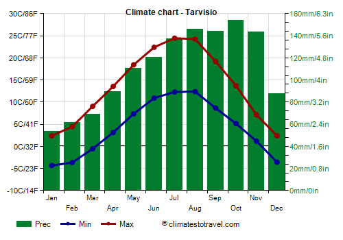
 is located in the north-east of the region, in a valley at an altitude of 750 metres (2,450 ft). The average temperature ranges from -1 °C (30 °F) in January to 18.5 °C (65.5 °F) in July.
In winter, heavy snowfalls can occur. During cold snaps, the temperature can drop to -15 °C (5 °F) and occasionally even below. As mentioned, thunderstorms can break out in summer, especially in the afternoon and in the evening. During heat waves, the temperature can reach 35 °C (95 °F).
Here are the average temperatures.
Tarvisio - Average temperatures (1991-2020) |
| Month | Min | Max | Mean |
|---|
| January | -4.3 | 2.4 | -1 |
|---|
| February | -3.7 | 4.4 | 0.4 |
|---|
| March | -0.5 | 9 | 4.3 |
|---|
| April | 3.1 | 13.6 | 8.3 |
|---|
| May | 7.4 | 18.4 | 12.9 |
|---|
| June | 10.9 | 22.4 | 16.7 |
|---|
| July | 12.3 | 24.5 | 18.4 |
|---|
| August | 12.4 | 24.2 | 18.3 |
|---|
| September | 8.7 | 19.2 | 13.9 |
|---|
| October | 5.1 | 13.7 | 9.4 |
|---|
| November | 1.2 | 7.1 | 4.2 |
|---|
| December | -3.6 | 2.4 | -0.6 |
|---|
| Year | 4.1 | 13.5 | 8.8 |
|---|
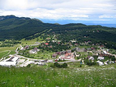
South of Tarvisio there are
ski slopes in Mount Lussari, 1,790 meters (5,873 ft) high, and in Mount Florianca.
Here are the average temperatures of
Mount Lussari.
Monte Lussari - Average temperatures (2007-2020) |
| Month | Min | Max | Mean |
|---|
| January | -6.3 | -1.9 | -4.1 |
|---|
| February | -6.5 | -2 | -4.3 |
|---|
| March | -3.9 | 1 | -1.5 |
|---|
| April | 0.2 | 5.8 | 3 |
|---|
| May | 3.2 | 9.1 | 6.1 |
|---|
| June | 7.7 | 13.8 | 10.8 |
|---|
| July | 9.6 | 16 | 12.8 |
|---|
| August | 9.8 | 15.9 | 12.8 |
|---|
| September | 5.7 | 10.8 | 8.2 |
|---|
| October | 2 | 6.6 | 4.3 |
|---|
| November | -1.4 | 2.8 | 0.7 |
|---|
| December | -4.7 | -0.4 | -2.5 |
|---|
| Year | 1.3 | 6.5 | 3.9 |
|---|
Other ski resorts in the region are Piancavallo, Sappada, Forni di Sopra, Ravascletto-Zoncolan and Sella Nevea/Plezzo.
The highest peak of Friuli-Venezia Giulia is
Mount Coglians, 2,780 meters (9,120 ft) high and located in the north-west, on the border with Austria.
Plain
In most of the plain of Friuli-Venezia Giulia (see Udine, Pordenone, Gorizia), there is a
moderately continental climate, with cold, damp winters and hot, muggy summers. The average temperatures in January are generally 4 °C (39 °F) in inland areas, and reach up to 6/6.5 °C (43/43.5 °F) on the coast.
In
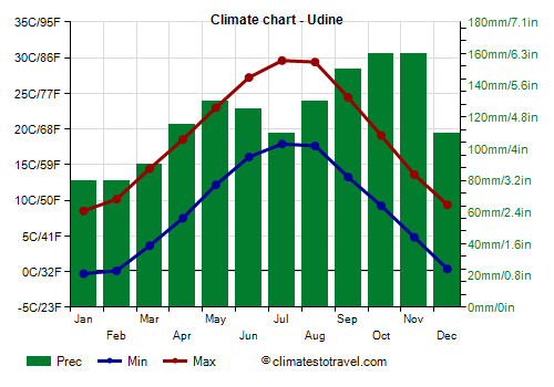
Udine, located in the plain about 10 km (6 mi) away from the Pre-Alps, the average temperature ranges from 4 °C (39 °F) in January to 23.5 °C (74.5 °F) in July.
Udine - Average temperatures (1991-2020) |
| Month | Min | Max | Mean |
|---|
| January | -0.3 | 8.5 | 4.1 |
|---|
| February | 0.1 | 10.2 | 5.1 |
|---|
| March | 3.6 | 14.4 | 9 |
|---|
| April | 7.5 | 18.5 | 13 |
|---|
| May | 12.2 | 23 | 17.6 |
|---|
| June | 16.1 | 27.2 | 21.6 |
|---|
| July | 17.9 | 29.6 | 23.7 |
|---|
| August | 17.6 | 29.4 | 23.5 |
|---|
| September | 13.3 | 24.4 | 18.8 |
|---|
| October | 9.2 | 19.1 | 14.2 |
|---|
| November | 4.8 | 13.6 | 9.2 |
|---|
| December | 0.4 | 9.4 | 4.9 |
|---|
| Year | 8.6 | 19 | 13.75 |
|---|
Rainfall is abundant, amounting to 1,450 mm (57 in) per year.
On the coast (see Lignano Sabbiadoro, Grado, Trieste) the climate is a little milder, so much so that it can be defined as
almost Mediterranean.
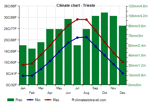
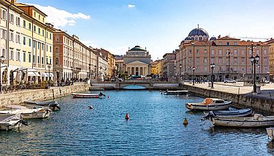
Trieste, the capital of the region, located in the easternmost part of the coast, outside the Venetian plain and close to the border with Slovenia. The average temperature ranges from 6.5 °C (43.5 °F) in January to 25 °C (77 °F) in July and August. Rainfall amounts to 1,000 mm (39.4 in ) per year.
Trieste - Average temperatures (1991-2020) |
| Month | Min | Max | Mean |
|---|
| January | 4.1 | 8.9 | 6.5 |
|---|
| February | 4.1 | 9.5 | 6.8 |
|---|
| March | 7 | 13.5 | 10.3 |
|---|
| April | 10.6 | 17.6 | 14.1 |
|---|
| May | 14.8 | 22.3 | 18.6 |
|---|
| June | 18.8 | 26.5 | 22.7 |
|---|
| July | 21 | 29.1 | 25 |
|---|
| August | 21.2 | 29 | 25.1 |
|---|
| September | 17.1 | 24.2 | 20.7 |
|---|
| October | 13.2 | 19 | 16.1 |
|---|
| November | 9.2 | 14.2 | 11.7 |
|---|
| December | 5.2 | 10.2 | 7.7 |
|---|
| Year | 12.3 | 18.7 | 15.45 |
|---|
Trieste is the mildest city in the region, however, it is particularly exposed to the
bora, because to the east of the city the wind is channeled through the mountains and increases in speed, bringing significant drops in temperature, especially in winter and spring.
The
sea on the coast of Friuli Venezia Giulia is warm enough for swimming in July and August, but basically also in September, while it is still a little cool in June.
Trieste - Sea temperature| Month |
|---|
| January | 11.5 |
|---|
| February | 10.5 |
|---|
| March | 11 |
|---|
| April | 13.5 |
|---|
| May | 18 |
|---|
| June | 22.5 |
|---|
| July | 25 |
|---|
| August | 25.5 |
|---|
| September | 23 |
|---|
| October | 19.5 |
|---|
| November | 16.5"> |
|---|
| December | 14 |
|---|
| Year | 17.6 |
|---|
Best Time
The best period to visit the
cities of Friuli-Venezia Giulia is that of spring and early summer, and in particular, from mid-April to mid-June. September, too, is a good month. However, you have to take into account some rainy days in both periods.
Summer can be hot, although some days can be acceptable, especially in June. In summer, and sometimes in May, sudden thunderstorms in the afternoon or evening must be put into account.
You can go to the
Alps either in winter, perhaps for skiing, and in summer, perhaps for trekking in the mountains and to escape the heat of the plains.
For a
beach holiday along the coast of Friuli-Venezia Giulia, the best period is the summer, particularly in July and August, since they are the hottest and sunniest months, and in which the sea is warmest as well.
See also the
temperatures by month.