Select units of measurement for the temperature and rainfall tables (metric or imperial).
Average weather, temperature, rainfall, sunshine hours
Basilicata (or Lucania) is a small region in southern Italy, crossed by the Lucanian Apennines and overlooking two seas: the Tyrrhenian Sea to the west (in a short stretch, of 16 km (10 mi), in the Gulf of Policastro) and the Ionian Sea to the southeast (in the Gulf of Taranto).
The climate is Mediterranean on the coasts, moderately continental in hilly and mountainous areas, and cold on the highest mountain peaks.
Precipitation in Basilicata is more abundant in the southwest, which is located on the western side and receives the humid currents of the Tyrrhenian Sea. In Maratea, near the coast, 1,200 mm (47 inches) of rain fall per year, while in Lagonegro, at an altitude of 660 metres (2,165 ft), 1,500 mm (60 in) fall. In the rest of the region, precipitation is generally lower than 800 mm (31.5 in) a year, and both in the Murge, in the north-east, and on the Ionian coast, in the south-east, it does not reach 600 mm (23.5 in) a year.
The coasts
On the coasts, the climate is
Mediterranean. Winters are mild and quite rainy (very rainy on the Tyrrhenian coast), while summers are hot and sunny, with rare rainy days and some thunderstorms. The Tyrrhenian coast (see Maratea) is a little milder, but also much more rainy, than the Ionian coast (see Policoro, Metaponto, Scanzano Jonico, Nova Siri Scalo).
For example, in
Metaponto, located on the Ionian coast, the average temperature ranges from 9 °C (48 °F) in January and February, to 26.5 °C (79.5 °F) in July.
Metaponto - Average temperatures (2001-2012) |
| Month | Min | Max | Mean |
|---|
| January | 4.9 | 12.9 | 8.9 |
|---|
| February | 4.8 | 13.1 | 9 |
|---|
| March | 7.4 | 16.1 | 11.8 |
|---|
| April | 9.8 | 18.8 | 14.3 |
|---|
| May | 14 | 24 | 19 |
|---|
| June | 18 | 28.9 | 23.4 |
|---|
| July | 20.7 | 32 | 26.4 |
|---|
| August | 20.6 | 31.5 | 26.1 |
|---|
| September | 16.9 | 26.6 | 21.7 |
|---|
| October | 13.4 | 22.3 | 17.9 |
|---|
| November | 9.4 | 17.8 | 13.6 |
|---|
| December | 6.4 | 13.9 | 10.2 |
|---|
| Year | 12.2 | 21.5 | 16.85 |
|---|
Despite the mild climate, in winter there can be cold and windy periods, with highs of 5 °C (41 °F) and lows down to 0/-2 °C (28/32 °F). In summer there can be very hot days, when the sirocco blows from Africa, with highs of 38/40 °C (100/104 °F).
On the coasts of Basilicata, the
sea is warm enough for swimming from July to September, while it is still a little cool in June, around 22 °C (71.5 °F). Here is the average sea temperature in Metaponto.
Metaponto - Sea temperature| Month |
|---|
| January | 14.5 |
|---|
| February | 14 |
|---|
| March | 14.5 |
|---|
| April | 15.5 |
|---|
| May | 18.5 |
|---|
| June | 22 |
|---|
| July | 25 |
|---|
| August | 26 |
|---|
| September | 24.5 |
|---|
| October | 21.5 |
|---|
| November | 18.5"> |
|---|
| December | 16 |
|---|
| Year | 19.2 |
|---|
In inland areas, at low altitude (see Tursi, Montalbano Jonico, Pisticci, Bernalda Metaponto), the climate is still Mediterranean, but takes on slightly continental characteristics, given that summer is very hot, while in winter, it can get cold at night and fog can form.
Hills and mountains

As the altitude increases, the climate becomes
moderately continental at hill altitudes, in the
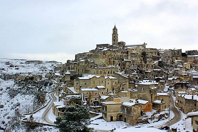
Murge, a karst plateau which is located in the north-east of the region, on the border with Apulia. In winter, during cold spells from the north-east, there can be snowfalls and frosts, while in summer, during invasions of hot air from Africa, the temperature can reach 38/40 °C (100/104 °F).
In
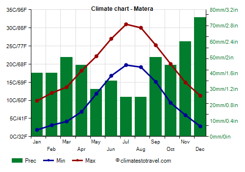
Matera, located at an altitude of 400 metres (1,300 feet), the average temperature ranges from 6 °C (43 °F) in January and February, to 25 °C (77 °F) in July.
Matera - Average temperatures (2015-2020) |
| Month | Min | Max | Mean |
|---|
| January | 1.8 | 9.9 | 5.9 |
|---|
| February | 3.2 | 12 | 7.6 |
|---|
| March | 4.2 | 13.6 | 8.9 |
|---|
| April | 6.8 | 18.2 | 12.5 |
|---|
| May | 11.8 | 22.2 | 17 |
|---|
| June | 16.8 | 27 | 21.9 |
|---|
| July | 19.8 | 31 | 25.4 |
|---|
| August | 19.2 | 30 | 24.6 |
|---|
| September | 15.1 | 25.2 | 20.2 |
|---|
| October | 9.3 | 20 | 14.7 |
|---|
| November | 5.9 | 14.9 | 10.4 |
|---|
| December | 2.8 | 11.3 | 7 |
|---|
| Year | 9.8 | 19.7 | 14.7 |
|---|


In the Apennines, above 700 metres (2,300 ft), the climate becomes
temperate.
In
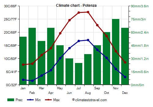
Potenza, the regional capital, located at an altitude of 820 metres (2,690 ft), the average temperature is around 5 °C (41 °F) in January and February, while it reaches 22/22.5 °C (71.5/72.5 °F) in July and August.
Potenza - Average temperatures (1991-2006) |
| Month | Min | Max | Mean |
|---|
| January | 2 | 7.7 | 4.9 |
|---|
| February | 1.6 | 8.1 | 4.8 |
|---|
| March | 3.6 | 11.4 | 7.5 |
|---|
| April | 5.6 | 14 | 9.8 |
|---|
| May | 10.2 | 19.7 | 14.9 |
|---|
| June | 14 | 24.6 | 19.3 |
|---|
| July | 16.7 | 27.5 | 22.1 |
|---|
| August | 17.1 | 27.7 | 22.4 |
|---|
| September | 13.4 | 22.7 | 18.1 |
|---|
| October | 10.3 | 18.6 | 14.5 |
|---|
| November | 6.1 | 12.8 | 9.5 |
|---|
| December | 3 | 8.6 | 5.8 |
|---|
| Year | 8.7 | 17 | 12.8 |
|---|
During cold waves, which are becoming rarer due to climate change, there can be heavy snowfalls, and the temperature can drop several degrees below freezing. Generally, the temperature does not drop below -7/-8 °C (18/19 °F), however, in January 1954, it dropped to -15.6 °C (3.9 °F) in Pescopagano, at an altitude of 950 metres (3,115 ft), while in January 1968, it dropped to -12 °C (10.5 °F) in Potenza.
In Basilicata there are also some
ski lifts, such as that of Mount Sirino and that of Sellata-Pierfaone. It must be said that in winter there is not always snow on the slopes, as the region is located in southern Italy and is subject to periods of mild weather.
The highest peak in the region is located on the border with Calabria, in the
Pollino Massif (protected in a national park), and reaches 2,248 meters (7,375 ft) in height.
Best Time
The best months for a
beach holiday in Basilicata are July and August. In June, the days are long and the weather is often good, but the sea is still a bit cool. You can still go in September, in fact the sea is still quite warm, but the days get shorter and the first waves of bad weather can occur, especially in the second half of the month.
To
visit the cities, you can choose the periods from mid-April to mid-May and from mid-September to mid-October, since in summer it can get very hot. It must be said that in both periods there may be rainy days.
See also the
temperatures by month.