Select units of measurement for the temperature and rainfall tables (metric or imperial).
Average weather, temperature, rainfall, sunshine
In East Timor, a small country located just south of the Equator, the climate is
tropical, hot all year round, with a rainy season from December to March and a dry season from June to September.
Rainfall is not very abundant, and generally amounts to 1,200/1,400 millimeters (47/55 inches) per year, but there are also some areas where it drops below 1,000 mm (40 in), such as that of Dili, located on the north coast. Given that the rains are abundant only from December to March, and that the dry season is quite long, the landscape is not particularly verdant; actually, in some areas, it is almost arid.
In the interior of East Timor, there is a
mountain range. The highest peak is Mount Ramelau (or Tatamailau), 2,963 meters (9,721 feet) high. If you are planning some hiking at high altitudes, keep in mind that above 1,000 meters (3,300 feet), it's cool in the evening and at night, especially in the dry season, while above 2,000 meters (6,500 feet), it can get quite cold. In addition, at noon and in the afternoon, the chance of thunderstorms in the highlands is higher than along the coasts.
The country includes the eastern part of the island of Timor, plus the smaller islands of
Atauro to the north, and
Jaco to the east. There is also the exclave of
Oecusse, in the western part of Timor, which, for the rest, belongs to Indonesia.
The climate in detail
Temperature and rain
Dili

In the capital,
Dili,
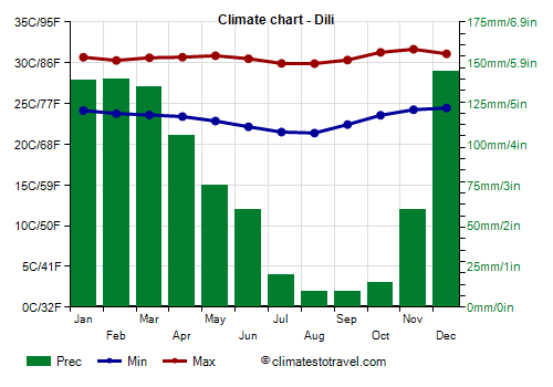
temperatures are high and uniform throughout the year. They are slightly higher from October to May and a bit lower from June to September, when highs are around 30 °C (86 °F). From September to November, and sometimes from mid-August, the hottest period of the year occurs. In the rainy season, high humidity makes the heat muggy.
As mentioned, Dili is located on the north side, the driest one, and in fact receives around 900 mm (35.5 in) of rain per year.
The amount of
sunshine in East Timor is good in the dry season, while in the rainy season, the sun shines for a few hours a day, between one rain shower and another. On the contrary, the sky is more easily cloudy in the interior, especially on the mountain peaks.

Sea temperature
The sea in East Timor is warm enough to swim in throughout the year: the water temperature ranges from 27 °C (81 °F) in July and August to 29 °C (84 °F) between October and May.
Cyclones
From November to mid-May, but more often from January to mid-April, East Timor can be affected by
tropical cyclones, which usually affect this area in the early stages of their development, and therefore at a moderate intensity; however, they can bring an increase in wind and rainfall.
When to go
The best time to travel to East Timor and enjoy its beaches is from
June to August: the sun shines, the heat is not too intense, and in any case, it's tempered by the breeze; there are just some short downpours or thunderstorms every now and then.
In September, it is often very hot. At the end of September or in October, the rains begin to increase in inland and mountainous areas.
What to pack
All year round, bring
light clothes of natural fibers, a sun hat, a scarf for the breeze, and a light sweatshirt for the evening. From November to March, you can add light raincoat or umbrella.
When going to the reef, you can bring snorkeling equipment, including water shoes or rubber-soled shoes.
When going mountain climbing, bring hiking shoes, a sweatshirt or sweater, a jacket, and a raincoat.
Climate data - East Timor
| Dili |
|---|
|
| Jan | Feb | Mar | Apr | May | Jun | Jul | Aug | Sep | Oct | Nov | Dec |
|---|
| Min temp. | 24 | 24 | 24 | 23 | 23 | 22 | 22 | 21 | 22 | 24 | 24 | 24 |
|---|
| Max temp. | 31 | 30 | 31 | 31 | 31 | 30 | 30 | 30 | 30 | 31 | 32 | 31 |
|---|
| Precip. | 140 | 140 | 135 | 105 | 75 | 60 | 20 | 10 | 10 | 15 | 60 | 145 |
|---|
| Prec. days | 13 | 13 | 11 | 9 | 6 | 4 | 3 | 1 | 1 | 2 | 6 | 11 |
|---|
| Humidity | 80% | 82% | 80% | 77% | 75% | 72% | 71% | 70% | 71% | 72% | 73% | 77% |
|---|
| Day length | 13 | 12 | 12 | 12 | 12 | 12 | 12 | 12 | 12 | 12 | 12 | 13 |
|---|
| Sun hours | 6 | 6 | 8 | 8 | 9 | 8 | 9 | 9 | 10 | 10 | 9 | 7 |
|---|
| Sea temp | 29 | 29 | 29 | 29 | 29 | 28 | 27 | 27 | 28 | 29 | 30 | 30 |
|---|