Select units of measurement for the temperature and rainfall tables (metric or imperial).
Average weather, temperature, rainfall, sunshine
The climate of Belgium is
cool and wet, being influenced by the Atlantic Ocean, especially on the coast and the plain. In the south-eastern regions (Ardennes), which are located at higher altitudes as well as at a greater distance from the sea, the climate is more continental, and also more unstable in summer.
Precipitation is frequent, but not particularly abundant,at least in the plains, where 800/850 millimeters (31/33 inches) of rain fall per year, while about 1,100 mm (43 in) fall in the Ardennes.
The climate in detail
The seasons
Winter is cold on the coast, but not freezing. The average temperature in February (which is, albeit slightly, the coldest month on the coast) is about 4 °C (39 °F). Sunshine is rare and the rains are frequent.
Proceeding towards the interior, the temperature gradually decreases. The rains are frequent here as well.
In the
Ardennes, the winter is colder, both because of the altitude and because of the greater distance from the sea. In Bastogne, Spa and Saint-Hubert, approximately 500 meters (1,600 feet) above sea level, the average January temperature drops to about 0 °C (32 °F), and snow often falls instead of rain.
Apart from the average temperatures, in winter, the weather in Belgium varies depending on meteorological condition.
The coldest days occur when the normal flow of Atlantic currents is arrested and is replaced by
cold air masses from Eastern Europe: in these cases, the temperature drops below freezing (0 °C or 32 °F), and snow can fall throughout the country. During the coldest winters, the temperature can drop to around -15 °C (5 °F).
On the contrary, when the westerlies get stronger, the temperature can become mild even in winter, above 10 °C (50 °F), but sometimes, there can be strong winds and even storm surges.
At other times, when a high pressure system moves over the country, a phenomenon quite rare but not impossible, the weather becomes cold and gray, and fog and low clouds can form.
 Summer
 is pretty cool on the coast, with maximum temperatures reaching 21/22 °C (68/72 °F) in July and August. Cloudy and rainy days, brought by Atlantic fronts, can occur in Belgium even in this season.
In inland areas, the weather in summer is slightly warmer: in Brussels, the daily average in July is about 18.5 °C (65.5 °F), with highs about 23.5 °C (74 °F), but here too, hot days are rare. The rains are more frequent because of the higher chance of afternoon thunderstorms.
As we said, the temperatures in the Ardennes are slightly lower than in the plains. Afternoon thunderstorms are even more frequent.
Sometimes, Belgium can be reached by
hot air masses, which can raise the temperatures above 30 °C (86 °F). These hot spells are becoming more frequent due to global warming. In July 2019, the temperature reached 37 °C (98.5 °F) in Spa, 39 °C (102 °F) in Ostend and 40 °C (104 °F) in Brussels.
Spring and autumn are cool and cloudy seasons. It can be still cold in March and in the first half of April, and sometimes even in early May, with highs around 10 °C (50 °F). Spring, however, is not as rainy as autumn, and it's the (relatively) driest season of the year. Autumn can be windy and gray, especially on the coast.
The cities
Ostend

In
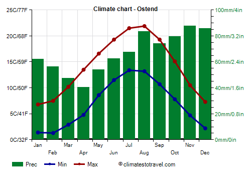
Ostend, which is located on the coast, in the mildest and least rainy area, the average temperature ranges from 4 °C (39 °F) in January to 17.5 °C (63.5 °F) in July and August.
On average, just over 800 mm (31.5 in) of rain fall per year. The rainiest period is from October to December, the least rainy from February to April.
The sun in Belgium is rarely seen from November to February, but it does not shine very often even in summer, however, the coast is the sunniest area of the country. In Ostend, there are 1,840 hours of sunshine per year, and from April to August the average exceeds 7 hours a day.
Even in mid-summer (July-August), the
sea in Belgium is cold: the water temperature is around 16 °C (61 °F) in July and 18 °C (64 °F).
Brussels

In
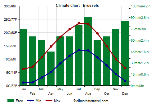
Brussels, the capital, the average temperature ranges from 3.5 °C (38 °F) in January to 18.5 °C (65.5 °F) in July and August.
The rains are about the same as in Ostend, though they are distributed a little differently, in fact, they are more abundant in summer and less in autumn.
In Brussels, the sun shines a little less than on the coast, for a total of 1,600 hours per year. However, from May to August, there are slightly more than 6 hours of sunshine per day on average.
Saint-Hubert

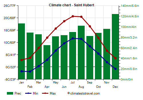
As mentioned, temperatures in the Ardennes are lower throughout the year. In
Saint-Hubert, at 565 meters (1,855 ft) above sea level, the average temperature ranges from 0.5 °C (33 °F) in January to 16 °C (61 °F) in July and August.
Precipitation is more abundant than in the plains, and in winter, it occurs quite often in the form of snow. In Saint-Hubert, it amounts to 1,100 mm (43 in) per year.
When to go
The best time to visit Belgium is from
mid-May to mid-September: the temperatures are mild, the sky is often cloudy, but the percentage of sunshine is not so low. The mid-summer period (July-August) is relatively warm, but it's also the rainiest because of afternoon thunderstorms that can form especially in inland areas.
As regards to the other seasons, while it is true that weather extremes in Belgium are rare, late autumn (November) is dark and rainy, while in winter, it can sometimes be very cold or windy.
What to pack
In
winter: bring warm clothing, a sweater, a coat, a wind jacket, an umbrella, and possibly a warm hat and gloves for colder periods.
In
summer: bring light clothes, but also some clothes for spring and autumn: a shirt, a jacket, a sweatshirt or sweater, and a raincoat or umbrella.
Climate data - Belgium
| Antwerp |
|---|
|
| Jan | Feb | Mar | Apr | May | Jun | Jul | Aug | Sep | Oct | Nov | Dec |
|---|
| Min temp. | 1 | 1 | 3 | 5 | 9 | 12 | 14 | 14 | 11 | 8 | 4 | 2 |
|---|
| Max temp. | 7 | 8 | 11 | 15 | 19 | 21 | 24 | 24 | 20 | 15 | 10 | 7 |
|---|
| Precip. | 70 | 55 | 50 | 45 | 60 | 75 | 85 | 85 | 70 | 65 | 80 | 90 |
|---|
| Prec. days | 12 | 11 | 10 | 9 | 10 | 10 | 10 | 10 | 9 | 10 | 12 | 13 |
|---|
| Humidity | 83% | 80% | 75% | 69% | 69% | 70% | 70% | 72% | 76% | 81% | 84% | 85% |
|---|
| Day length | 8 | 10 | 12 | 14 | 16 | 16 | 16 | 14 | 13 | 11 | 9 | 8 |
|---|
| Sun hours | 2 | 3 | 4 | 6 | 7 | 7 | 7 | 7 | 5 | 4 | 2 | 2 |
|---|
|
| Arlon (400 meters) |
|---|
|
| Jan | Feb | Mar | Apr | May | Jun | Jul | Aug | Sep | Oct | Nov | Dec |
|---|
| Min temp. | -1 | -2 | 1 | 3 | 7 | 10 | 12 | 12 | 8 | 6 | 2 | 0 |
|---|
| Max temp. | 4 | 5 | 10 | 14 | 18 | 21 | 23 | 23 | 19 | 13 | 8 | 5 |
|---|
| Precip. | 120 | 95 | 80 | 65 | 75 | 80 | 80 | 85 | 80 | 100 | 105 | 145 |
|---|
| Prec. days | 14 | 13 | 12 | 10 | 11 | 10 | 11 | 10 | 10 | 12 | 14 | 16 |
|---|
|
|
| Sun hours | 2 | 3 | 4 | 7 | 7 | 7 | 8 | 7 | 5 | 3 | 2 | 1 |
|---|
|
| Brussels |
|---|
|
| Jan | Feb | Mar | Apr | May | Jun | Jul | Aug | Sep | Oct | Nov | Dec |
|---|
| Min temp. | 1 | 1 | 3 | 5 | 8 | 11 | 13 | 13 | 11 | 8 | 4 | 2 |
|---|
| Max temp. | 6 | 7 | 11 | 15 | 18 | 21 | 24 | 23 | 20 | 15 | 10 | 7 |
|---|
| Precip. | 75 | 65 | 60 | 45 | 65 | 65 | 80 | 90 | 60 | 65 | 75 | 85 |
|---|
| Prec. days | 13 | 12 | 11 | 9 | 10 | 10 | 10 | 10 | 10 | 10 | 12 | 13 |
|---|
| Humidity | 84% | 81% | 76% | 70% | 71% | 72% | 72% | 73% | 77% | 82% | 86% | 86% |
|---|
| Day length | 8 | 10 | 12 | 14 | 16 | 16 | 16 | 14 | 13 | 11 | 9 | 8 |
|---|
| Sun hours | 2 | 3 | 4 | 6 | 6 | 7 | 7 | 6 | 5 | 4 | 2 | 2 |
|---|
|
| Charleroi |
|---|
|
| Jan | Feb | Mar | Apr | May | Jun | Jul | Aug | Sep | Oct | Nov | Dec |
|---|
| Min temp. | 1 | 1 | 2 | 5 | 8 | 11 | 13 | 13 | 10 | 7 | 4 | 1 |
|---|
| Max temp. | 6 | 7 | 11 | 15 | 18 | 21 | 24 | 23 | 20 | 15 | 10 | 6 |
|---|
| Precip. | 80 | 70 | 65 | 50 | 65 | 75 | 75 | 85 | 65 | 65 | 75 | 100 |
|---|
| Prec. days | 13 | 12 | 11 | 9 | 10 | 10 | 10 | 10 | 10 | 11 | 12 | 14 |
|---|
|
|
| Sun hours | 2 | 3 | 4 | 6 | 7 | 7 | 7 | 7 | 5 | 4 | 2 | 2 |
|---|
|
| Liège |
|---|
|
| Jan | Feb | Mar | Apr | May | Jun | Jul | Aug | Sep | Oct | Nov | Dec |
|---|
| Min temp. | 1 | 1 | 3 | 6 | 9 | 12 | 14 | 14 | 11 | 8 | 4 | 2 |
|---|
| Max temp. | 6 | 7 | 11 | 15 | 19 | 22 | 24 | 24 | 20 | 15 | 10 | 7 |
|---|
| Precip. | 70 | 65 | 60 | 55 | 70 | 80 | 80 | 85 | 70 | 65 | 70 | 90 |
|---|
| Prec. days | 13 | 12 | 12 | 10 | 11 | 11 | 11 | 11 | 10 | 11 | 13 | 15 |
|---|
|
|
| Sun hours | 2 | 3 | 4 | 6 | 7 | 7 | 7 | 7 | 5 | 4 | 2 | 2 |
|---|
|
| Ostend |
|---|
|
| Jan | Feb | Mar | Apr | May | Jun | Jul | Aug | Sep | Oct | Nov | Dec |
|---|
| Min temp. | 1 | 1 | 3 | 5 | 9 | 12 | 13 | 13 | 11 | 8 | 5 | 2 |
|---|
| Max temp. | 7 | 8 | 10 | 14 | 17 | 19 | 22 | 22 | 19 | 15 | 10 | 7 |
|---|
| Precip. | 60 | 55 | 45 | 40 | 55 | 60 | 70 | 85 | 75 | 80 | 90 | 85 |
|---|
| Prec. days | 12 | 10 | 10 | 8 | 9 | 9 | 9 | 10 | 10 | 12 | 14 | 14 |
|---|
|
|
| Sun hours | 2 | 3 | 5 | 7 | 7 | 8 | 8 | 7 | 6 | 4 | 2 | 2 |
|---|
| Sea temp | 8 | 7 | 7 | 9 | 11 | 14 | 16 | 18 | 17 | 15 | 12 | 10 |
|---|
| Saint Hubert (565 meters) |
|---|
|
| Jan | Feb | Mar | Apr | May | Jun | Jul | Aug | Sep | Oct | Nov | Dec |
|---|
| Min temp. | -2 | -2 | 0 | 3 | 7 | 10 | 12 | 12 | 8 | 6 | 2 | -1 |
|---|
| Max temp. | 3 | 4 | 8 | 12 | 16 | 19 | 21 | 20 | 17 | 12 | 7 | 4 |
|---|
| Precip. | 105 | 90 | 85 | 65 | 80 | 85 | 90 | 100 | 80 | 90 | 95 | 125 |
|---|
| Prec. days | 15 | 13 | 14 | 10 | 12 | 11 | 12 | 12 | 11 | 13 | 15 | 17 |
|---|
|
|
| Sun hours | 2 | 3 | 4 | 6 | 6 | 7 | 7 | 7 | 5 | 3 | 2 | 1 |
|---|
|
| Spa (480 meters) |
|---|
|
| Jan | Feb | Mar | Apr | May | Jun | Jul | Aug | Sep | Oct | Nov | Dec |
|---|
| Min temp. | -1 | -1 | 1 | 4 | 8 | 10 | 13 | 12 | 9 | 6 | 3 | 0 |
|---|
| Max temp. | 4 | 5 | 9 | 13 | 17 | 20 | 22 | 21 | 18 | 13 | 8 | 4 |
|---|
| Precip. | 100 | 90 | 85 | 65 | 80 | 90 | 95 | 100 | 90 | 85 | 95 | 120 |
|---|
| Prec. days | 15 | 13 | 13 | 10 | 12 | 12 | 12 | 12 | 11 | 12 | 14 | 17 |
|---|
|
|
| Sun hours | 2 | 3 | 4 | 6 | 6 | 7 | 7 | 6 | 5 | 3 | 2 | 1 |
|---|
|
See also the
temperatures month by month