Select units of measurement for the temperature and rainfall tables (metric or imperial).
Average weather, temperature, rainfall, sunshine
The climate of the Azores Islands is
subtropical oceanic, pleasantly warm in summer yet cool, rainy and windy for many months.
The archipelago, a Portuguese autonomous region, is located in the Atlantic Ocean at the same latitude as central and southern Portugal. However, the influence of the ocean makes the climate mild by comparison, especially in the summer, when the temperature is lower than in the mainland.
The Azores do not get a lot of
sun, especially in the period from October to April, when the skies are often cloudy. On average, there are about 1,700 hours of sunshine per year in the north-western islands and 1,900 hours in the south-eastern ones.
From July to September, the
ocean is not particularly warm, yet may be acceptable for swimming for those who are not sensitive to the cold. The water temperature is 22 °C (72 °F) in July and 23/23.5 °C (73/74 °F) in August and September.
Some of the islands are covered by hills or mountains. The highest peak is
Mount Pico, on the island of the same name; it's a volcano of 2,351 meters (7,713 feet) and is also the highest mountain in Portugal. On the slopes of the mountain, there is not much sun and the rainfall is abundant, while the summit can be covered with snow in winter and spring.
The climate in detail
Temperature

In
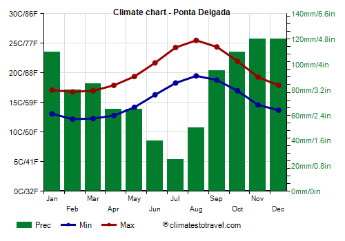
Ponta Delgada, the capital of the Azores islands, located on the southern coast of the island of São Miguel, the average temperature ranges from 14.5 °C (58 °F) in February and March, to 22.5 °C (72.5 °F) in August.
The winter temperatures range from 12/13 °C (53/55 °F) at night to 17/18 °C (63/64 °F) during the day, while in summer, they range from 17/18 °C (63/64 °F) at night to 24/26 °C (75/79 °F) during the day. The temperature varies incrementally from one month to the other, and highs exceed 20 °C (68 °F) only from June to October.
Given that they are very far from the continents (and from the Pole), the Azores do not experience real
heat waves in summer or
cold waves in winter. In winter, cold air comes from Canada, after having crossed the Atlantic Ocean for a long distance, and mainly affects the northwesternmost islands (Flores and Corvo).
The highest
records on the Azores are not impressive, being around 30 °C (86 °F). In August 2010 and 2011, at Lajes airport, in the north of the island of Terceira, the temperature reached 31.5 °C (88.5 °F), while in September 1985, at the Pico Island airport, it reached 32 °C (89.5 °F).
On the other hand, temperatures rarely drop below 7/8 °C (45/46 °F) in winter. However, cold records on the coasts are around 3/4 °C (37/39 °F) in most of the islands, and 2 °C (35.5 °F) in Flores (the latter recorded in January 1985).
Rainfall
The famous anticyclone (high pressure area) that brings fine weather to Western Europe and the Mediterranean (i.e. the Azores High) got its name from the Azores, interestingly enough however, the weather on these islands is not always sunny. In fact, in autumn and winter, the
rains are frequent, and on the north-western islands, they are also abundant. In addition, sometimes there can be wind storms in the period from November to March.

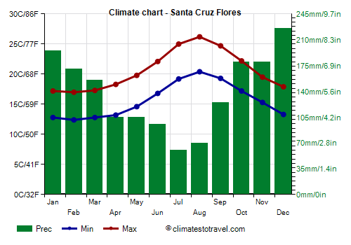
Owing to the abundance of rainfall, the environment is green and blossoming; flowers paint the landscape mainly in spring, and they also gave the name to the westernmost and very rainy island of
Flores ("flowers").
The rainfall is below 750 millimeters (29.5 inches) per year on the island of
Santa Maria (the southeasternmost island), it's above 900 mm (35 in) in São Miguel, while it reaches or exceeds 1,000 mm (40 in) on the other islands (see
Angra do Heroísmo, on the island of Terceira). In the summer months, from June to August, the rains are a bit more rare and less abundant, but they still occur for 5/7 days per month on average.

Hurricanes
Occasionally, the Azores islands can be affected by hurricanes, the
tropical cyclones of the Atlantic, although they generally arrive weakened because they have to move into a sea that is not very warm. Generally, hurricanes move northeast after hitting the Caribbean, but sometimes they can come directly from the south, from the Cape Verde area. The Azores are almost always reached in September or October.
Some hurricanes that hit the archipelago were:
At the beginning of September 1899, the "Great Bahamas" hurricane, which had hit the Caribbean in August, struck the island of São Miguel.
Hurricane Carrie in September 1957.
Hurricane Debbie in September 1961.
Hurricane Emmy at the beginning of September 1976.
In September 1992, two hurricanes, Bonnie and Charley, passed one after the other within a few days.
Hurricane Tanya in early November 1995.
Hurricane Gordon, which mainly affected the island of Santa Maria on September 20, 2006, with gusts at 130 kph (80 mph).
Another hurricane named Gordon affected the island of Santa Maria in August 2012.
In January 2016, in an absolutely anomalous period, hurricane Alex affected the islands, after having weakened to a tropical storm; however, it brought heavy rains and strong winds.
Hurricane Ophelia in early October 2017.
Hurricane Lorenzo at the beginning of October 2019.
When to go
The best time to visit the Azores is summer, in
July and August, since it is the warmest and sunniest time of the year.
Because of their oceanic climate, the Azores experience a delay in the sea getting warm, which affects the air temperature as well, so much so that September is slightly warmer than June, and temperature-wise September is still a summer month, even though the rains become a bit more frequent.
In July and August, the temperatures are pleasant; the sun shines quite often and there is not much rain. In June, it is a bit cooler and cloudier by comparison.
What to pack
In
winter: bring spring/autumn clothes, a sweater, a jacket, and a raincoat.
In
summer: bring light clothing, but also a sweatshirt or sweater, a light scarf for the wind, a light jacket, and a raincoat or umbrella.
Climate data - Azores
| Angra Heroismo |
|---|
|
| Jan | Feb | Mar | Apr | May | Jun | Jul | Aug | Sep | Oct | Nov | Dec |
|---|
| Min temp. | 14 | 13 | 13 | 13 | 15 | 17 | 19 | 20 | 19 | 17 | 15 | 14 |
|---|
| Max temp. | 17 | 17 | 17 | 18 | 19 | 22 | 24 | 26 | 24 | 22 | 19 | 17 |
|---|
| Precip. | 110 | 110 | 100 | 85 | 60 | 50 | 35 | 55 | 95 | 120 | 130 | 135 |
|---|
| Prec. days | 13 | 12 | 12 | 10 | 9 | 6 | 5 | 7 | 9 | 13 | 13 | 14 |
|---|
|
| Day length | 10 | 11 | 12 | 13 | 14 | 15 | 14 | 14 | 12 | 11 | 10 | 10 |
|---|
| Sun hours | 4 | 4 | 4 | 5 | 7 | 7 | 8 | 8 | 6 | 5 | 3 | 3 |
|---|
| Sea temp | 16 | 16 | 16 | 16 | 17 | 19 | 22 | 23 | 23 | 21 | 19 | 17 |
|---|
| Horta |
|---|
|
| Jan | Feb | Mar | Apr | May | Jun | Jul | Aug | Sep | Oct | Nov | Dec |
|---|
| Min temp. | 14 | 13 | 13 | 14 | 15 | 17 | 19 | 21 | 20 | 18 | 16 | 14 |
|---|
| Max temp. | 17 | 17 | 17 | 18 | 19 | 22 | 24 | 26 | 25 | 22 | 20 | 18 |
|---|
| Precip. | 120 | 80 | 60 | 60 | 65 | 65 | 35 | 50 | 70 | 130 | 105 | 100 |
|---|
| Prec. days | 19 | 16 | 17 | 15 | 14 | 12 | 10 | 11 | 13 | 17 | 17 | 19 |
|---|
|
|
| Sun hours | 3 | 3 | 4 | 5 | 6 | 6 | 7 | 8 | 6 | 5 | 3 | 3 |
|---|
| Sea temp | 16 | 16 | 16 | 16 | 17 | 19 | 22 | 23 | 23 | 21 | 19 | 18 |
|---|
| Ponta Delgada |
|---|
|
| Jan | Feb | Mar | Apr | May | Jun | Jul | Aug | Sep | Oct | Nov | Dec |
|---|
| Min temp. | 13 | 12 | 12 | 13 | 14 | 16 | 18 | 20 | 19 | 17 | 15 | 14 |
|---|
| Max temp. | 17 | 17 | 17 | 18 | 19 | 22 | 24 | 26 | 24 | 22 | 19 | 18 |
|---|
| Precip. | 110 | 80 | 85 | 65 | 65 | 40 | 25 | 50 | 95 | 110 | 120 | 120 |
|---|
| Prec. days | 13 | 12 | 11 | 10 | 9 | 6 | 6 | 6 | 10 | 11 | 13 | 14 |
|---|
| Humidity | 81% | 80% | 79% | 79% | 79% | 81% | 79% | 79% | 79% | 79% | 78% | 81% |
|---|
| Day length | 10 | 11 | 12 | 13 | 14 | 15 | 14 | 14 | 12 | 11 | 10 | 10 |
|---|
| Sun hours | 3 | 4 | 4 | 5 | 6 | 5 | 7 | 7 | 6 | 5 | 4 | 3 |
|---|
| Sea temp | 17 | 16 | 16 | 17 | 18 | 20 | 22 | 23 | 23 | 21 | 19 | 18 |
|---|
| Santa Cruz Flores |
|---|
|
| Jan | Feb | Mar | Apr | May | Jun | Jul | Aug | Sep | Oct | Nov | Dec |
|---|
| Min temp. | 13 | 12 | 13 | 13 | 15 | 17 | 19 | 20 | 19 | 17 | 15 | 13 |
|---|
| Max temp. | 17 | 17 | 17 | 18 | 20 | 22 | 25 | 26 | 25 | 22 | 20 | 18 |
|---|
| Precip. | 195 | 170 | 155 | 105 | 105 | 95 | 60 | 70 | 125 | 180 | 180 | 225 |
|---|
| Prec. days | 17 | 17 | 15 | 12 | 10 | 9 | 8 | 10 | 13 | 14 | 15 | 18 |
|---|
| Humidity | 77% | 76% | 76% | 76% | 76% | 77% | 77% | 76% | 77% | 76% | 77% | 76% |
|---|
| Day length | 10 | 11 | 12 | 13 | 14 | 15 | 15 | 14 | 12 | 11 | 10 | 9 |
|---|
| Sun hours | 2 | 3 | 4 | 4 | 5 | 6 | 7 | 7 | 5 | 4 | 3 | 2 |
|---|
| Sea temp | 16 | 16 | 16 | 16 | 17 | 19 | 22 | 23 | 23 | 21 | 19 | 17 |
|---|
| Santa Maria |
|---|
|
| Jan | Feb | Mar | Apr | May | Jun | Jul | Aug | Sep | Oct | Nov | Dec |
|---|
| Min temp. | 13 | 12 | 13 | 13 | 15 | 17 | 19 | 20 | 19 | 18 | 15 | 14 |
|---|
| Max temp. | 17 | 17 | 18 | 19 | 20 | 22 | 25 | 26 | 25 | 23 | 20 | 18 |
|---|
| Precip. | 85 | 70 | 65 | 55 | 40 | 20 | 25 | 35 | 60 | 75 | 115 | 80 |
|---|
| Prec. days | 12 | 11 | 10 | 7 | 5 | 4 | 4 | 6 | 8 | 10 | 11 | 12 |
|---|
| Humidity | 81% | 80% | 78% | 78% | 77% | 79% | 77% | 77% | 77% | 79% | 78% | 81% |
|---|
| Day length | 10 | 11 | 12 | 13 | 14 | 15 | 14 | 14 | 12 | 11 | 10 | 10 |
|---|
| Sun hours | 3 | 4 | 4 | 5 | 7 | 7 | 8 | 8 | 6 | 5 | 4 | 3 |
|---|
| Sea temp | 18 | 18 | 18 | 18 | 19 | 20 | 22 | 23 | 23 | 23 | 21 | 19 |
|---|
See also the
temperatures month by month