Select units of measurement for the temperature and rainfall tables (metric or imperial).
March in Australia is the last summer month, and it is still a hot, muggy and rainy month in the north, very hot (but less than in previous months) in the desert areas, and very mild or pleasantly warm in the south-east.
In the
tropical north, in the Top End of the Northern Territory and in northern Queensland (see Darwin, Cairns), it is a hot, muggy and rainy month, with abundant rainfall.
On the
east coast (see Brisbane, Sydney), it is a hot month as well, with quite frequent rain, but it is less rainy than in the north, and gradually less hot as you proceed south.
In the
Outback, the vast arid or desert inland area (see Alice Springs, Oodnadatta), it is very hot and the sun shines, although every now and then a thunderstorm can break out.
In the south, in the areas where the climate is Mediterranean (see Perth, Adelaide), it is a hot month, but without the excesses of the desert areas, and sunny.
In the
south-east, in the areas where the climate is oceanic (see Melbourne, Tasmania), the temperature is mild to pleasantly warm, and the weather is variable, sometimes cool and windy, with possible rains, although not very frequent.
As regards to the
temperatures, March is slightly less hot than January and February, especially in inland areas, but as mentioned, on average it is still a summer month. The daily average is 27/28 °C (81/82 °F) in the desert areas south of the tropic (see Oodnadatta, Meekatharra), and still 30/31 °C (86/88 °F) north of the tropic, even on the north-west coast (see Port Hedland), it is 22/23 °C (72/73 °F) on the east coast (see Brisbane, Sydney) and in Perth, while it drops to 18.5 °C (65 °F) in Melbourne, in the south-east, and 16 °C (61 °F) in Hobart, Tasmania.
Sometimes, on the central-southern coasts there may be heat waves from the desert, during which the temperature can exceed 35 °C (95 °F).
Instead, in the south and in the central-southern inland areas, air masses of Antarctic origin can bring a bit of
cold at night, with minimum temperatures below 10 °C (50 °F).
As far as
rainfall is concerned, summer in Australia is the wettest season in the center-north, even though in March the rains decrease a little compared to February. However, the rains are very abundant only in the tropical north (see Darwin, Cairns), and are relatively abundant, often in the form of showers or thunderstorms, on the east coast (see Brisbane, Sydney), while in the Outback, only rare thunderstorms occur.
In the south, in the areas where the climate is Mediterranean (see Perth, Adelaide), summer is the dry season. In the south-east, with an oceanic climate (see Melbourne, Tasmania), summer is the relatively dry season, although the rains are quite frequent, even though not abundant. However, in the western part of Tasmania, they increase compared to the previous months.
In the warm season, central-northern Australia, especially the coasts, can be affected by
tropical cyclones. Cyclones mainly affect the northern coasts, although they can sometimes penetrate inland (especially Western Australia), weakening along the way but still bringing heavy rainfall.
Cyclones typically form from mid-November to mid-May, but are more likely from January to mid-April.
In the following image, we can see the areas that were affected by cyclones in the period 1950-2005 (the points refer to the eye of the storm, so the affected area is larger).
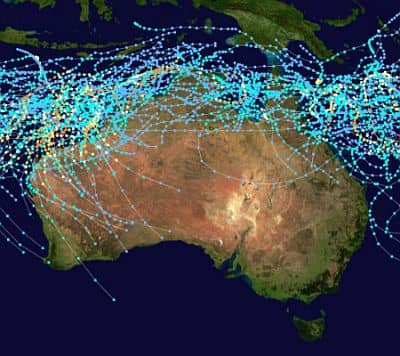 Area affected by cyclones in Australia
In March, the
sea in Australia is warm enough for swimming in the center-north. In the tropical north it is very warm, on the east coast it is quite warm approximately up to Wollongong (south of Sydney), on the western coast, it is a little cool but basically acceptable in Perth, while in the south, it is cold in Melbourne and very cold in Tasmania.
Australia - Climate data in March| City | Rainfall | Sun | Daylight |
|---|
| (north to south) | Min | Max | Days | Hours | Hours |
|---|
| Darwin | 25 | 32 | 315 | 17 | 6.9 | 12.2 |
|---|
| Cairns | 23 | 31 | 375 | 15 | 6.5 | 12.2 |
|---|
| Port Hedland | 25 | 37 | 70 | 3 | 9.3 | 12.2 |
|---|
Alice Springs
(575 m.) | 18 | 34 | 20 | 2 | 9.7 | 12.2 |
|---|
| Brisbane | 19 | 28 | 115 | 10 | 7.5 | 12.2 |
|---|
| Oodnadatta | 20 | 34 | 14 | 2 | 10.1 | 12.2 |
|---|
| Perth | 16 | 30 | 20 | 2 | 9.6 | 12.2 |
|---|
| Sydney | 18 | 26 | 95 | 9 | 6.8 | 12.3 |
|---|
| Adelaide | 15 | 26 | 20 | 3 | 8.6 | 12.3 |
|---|
Canberra
(570 m.) | 11 | 25 | 40 | 4 | 8.1 | 12.3 |
|---|
| Melbourne | 13 | 24 | 40 | 6 | 7.3 | 12.3 |
|---|
| Hobart | 11 | 21 | 35 | 7 | 6.8 | 12.3 |
|---|
See also: Australia, the weather in
February -
AprilThe climate of
Australia