Select units of measurement for the temperature and rainfall tables (metric or imperial).
Average weather, temperature, rainfall, sunshine hours

Da Lat has a
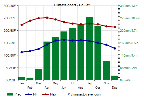
subtropical climate, influenced by altitude, with a dry season from December to March and a rainy season from May to October, with April and November as transition months.
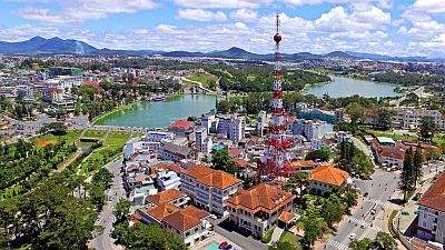
The city is the capital of Lâm Đồng province and is located in the central highlands of Vietnam, at an altitude of 1,500 meters (4,900 feet).
Da Lat is the city of some importance located at the highest altitude in Vietnam, and has a decidedly milder climate than other cities in the country, so much so that it is considered the city of eternal spring.
Fog can form all year round, in winter at night and in the early morning, while in the rainy period it can be persistent, especially in September and October.
Winter, from December to February, is mild and sunny. Nights are cool, and sometimes they can be a little cold, in fact the temperature can drop up to 5/6 °C (41/43 °F).
By mid-February, the temperature rises, and March to May is the
warmest period of the year. In April and May the temperature can reach 29/30 °C (84/86 °F). In April, the rains increase, even though the real monsoon hasn't arrived yet.
From May to October is the
monsoon period, with frequent and sometimes heavy rains, slightly lower daytime temperatures and high humidity. Sometimes the rains can cause floods. In November, the monsoon rains become relatively rare, but typhoons can still pass.

In fact, Da Lat can be hit by
typhoons, the tropical cyclones of Southeast Asia, although it must be said that the area most at risk is the coast. Typically, typhoons pass in this area from late April to late June (more rarely and generally not strong) and
from the beginning of September to 10 December.
Best Time
The best time to visit Da Lat is the dry season,
December to March. Sometimes, it can get cold at night, especially from mid-December to late February.
Da Lat - Climate data
In Da Lat, the
average temperature of the coldest month (January) is of
16.8 °C, that of the warmest month (May) is of
20.2 °C. Here are the average temperatures.
Da Lat - Average temperatures (1964-1998) |
| Month | Min | Max | Mean |
|---|
| January | 11.3 | 22.3 | 16.8 |
|---|
| February | 11.7 | 24 | 17.8 |
|---|
| March | 12.6 | 25 | 18.8 |
|---|
| April | 14.4 | 25.2 | 19.8 |
|---|
| May | 16 | 24.5 | 20.2 |
|---|
| June | 16.3 | 23.4 | 19.8 |
|---|
| July | 16 | 22.8 | 19.4 |
|---|
| August | 16.1 | 22.5 | 19.3 |
|---|
| September | 15.8 | 22.8 | 19.3 |
|---|
| October | 15.1 | 22.5 | 18.8 |
|---|
| November | 14.3 | 21.7 | 18 |
|---|
| December | 12.8 | 21.4 | 17.1 |
|---|
| Year | 14.4 | 23.2 | 18.75 |
|---|
amounts to
1750 millimeters per year: it is therefore abundant. It ranges from
10 millimeters in the driest month (February) to
280 millimeters in the wettest one (September). Here is the average precipitation.
Da Lat - Average precipitation| Month | Days |
|---|
| January | 14 | 2 |
|---|
| February | 10 | 2 |
|---|
| March | 50 | 5 |
|---|
| April | 170 | 11 |
|---|
| May | 190 | 16 |
|---|
| June | 215 | 20 |
|---|
| July | 230 | 22 |
|---|
| August | 250 | 23 |
|---|
| September | 280 | 24 |
|---|
| October | 240 | 19 |
|---|
| November | 85 | 8 |
|---|
| December | 20 | 3 |
|---|
| Year | 1750 | 155 |
|---|
There are on average around 2240
sunshine hours per year. Here are the average hours of sunshine per day.
Da Lat - Sunshine hours| Month | Average | Total |
|---|
| January | 8 | 255 |
|---|
| February | 8.5 | 235 |
|---|
| March | 8 | 255 |
|---|
| April | 6.5 | 200 |
|---|
| May | 6 | 190 |
|---|
| June | 5 | 145 |
|---|
| July | 5 | 155 |
|---|
| August | 4.5 | 135 |
|---|
| September | 4.5 | 135 |
|---|
| October | 4.5 | 140 |
|---|
| November | 5.5 | 170 |
|---|
| December | 7 | 215 |
|---|
| Year | 6.1 | 2240 |
|---|