Select units of measurement for the temperature and rainfall tables (metric or imperial).
Average weather, temperature, rainfall, sunshine hours

The climate of Sequim is
sub-oceanic, with quite mild, rainy winters and mild, fairly sunny summers.
The town is located in the north of
Washington state, on the coast of Juan de Fuca Strait, beyond which lies Canada. Seattle is located 75 km (45 mi) to the southeast.
Even though we are in a cool and humid area, the city has an
arid and sunny microclimate because it is protected from the southwest winds by the Olympic Mountains.
Although the
winter is mild enough, there can sometimes be cold waves, sometimes even in November, with lows going down to -10 °C (14 °F) or even below.
Snow, already rare in the area due to the prevalence of mild currents from the ocean, is even more so in Sequim due to the arid microclimate: just 4 cm (1.6 in) of snow fall in a year. However, occasionally there can be a heavy snowfall, as happened in February 2011 and 2019.
In
summer, it rarely gets hot because of the influence of the ocean, and even when it does, the temperature drops a lot at night. Generally, the temperature does not go above 33/34 °C (91/93 °F) on the hottest days, but sometimes it does not even reach 30 °C (86 °F) for a whole month.

Best Time
The best time to visit Sequim is summer, especially in July and August, since it is the mildest, driest and sunniest period of the year. May, June and September are also acceptable months.
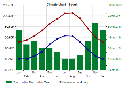
Sequim - Climate data
In Sequim, the
average temperature of the coldest month (December) is of
3.8 °C, that of the warmest months (July, August) is of
16 °C. Here are the average temperatures.
Sequim - Average temperatures (1991-2020) |
| Month | Min | Max | Mean |
|---|
| January | 0.2 | 7.9 | 4 |
|---|
| February | 0.1 | 8.8 | 4.4 |
|---|
| March | 1.4 | 10.7 | 6.1 |
|---|
| April | 3.3 | 13.2 | 8.2 |
|---|
| May | 6.8 | 16.4 | 11.6 |
|---|
| June | 9.3 | 18.6 | 13.9 |
|---|
| July | 10.8 | 21.1 | 16 |
|---|
| August | 10.6 | 21.3 | 16 |
|---|
| September | 7.9 | 18.8 | 13.4 |
|---|
| October | 4.4 | 14.2 | 9.3 |
|---|
| November | 1.4 | 10.2 | 5.8 |
|---|
| December | -0.1 | 7.7 | 3.8 |
|---|
| Year | 4.7 | 14.1 | 9.4 |
|---|
amounts to
430 millimeters per year: it is therefore quite scarce. It ranges from
15 millimeters in the driest months (July, August) to
65 millimeters in the wettest one (November). Here is the average precipitation.
Sequim - Average precipitation| Month | Days |
|---|
| January | 55 | 16 |
|---|
| February | 35 | 14 |
|---|
| March | 40 | 14 |
|---|
| April | 30 | 12 |
|---|
| May | 30 | 11 |
|---|
| June | 25 | 9 |
|---|
| July | 15 | 5 |
|---|
| August | 15 | 5 |
|---|
| September | 20 | 9 |
|---|
| October | 40 | 13 |
|---|
| November | 65 | 17 |
|---|
| December | 55 | 17 |
|---|
| Year | 430 | 141 |
|---|
The
sea temperature ranges from
7.5 °C in January, February to
14 °C in July, August. Here are the average sea temperatures.
Sequim - Sea temperature| Month |
|---|
| January | 7.5 |
|---|
| February | 7.5 |
|---|
| March | 8.5 |
|---|
| April | 9.5 |
|---|
| May | 11.5 |
|---|
| June | 13.5 |
|---|
| July | 14 |
|---|
| August | 14 |
|---|
| September | 13 |
|---|
| October | 11 |
|---|
| November | 9.5"> |
|---|
| December | 8.5 |
|---|
| Year | 10.7 |
|---|