Select units of measurement for the temperature and rainfall tables (metric or imperial).
Average weather, temperature, rainfall, sunshine hours
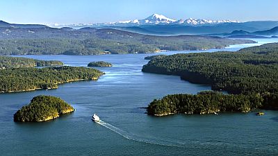
The climate of the San Juan Islands is
sub-oceanic, with quite mild, rainy winters and mild, fairly sunny summers.
The archipelago is located in the northwest of
Washington state, east of the Canadian island of Vancouver, between the Strait of Georgia and the Strait of Juan de Fuca. The main islands are Orcas, San Juan, Lopez, Shaw (the first four, served by the Washington State Ferries), Decatur and Blakely.
Even though we are in a humid area, the islands are affected, especially in the southern part, by the
rain shadow generated by the Olympic Mountains. For this reason, rainfall is lower than 1,000 millimeters (40 inches) per year, and it drops even below 500 mm (20 in) in the southernmost part of Lopez and San Juan islands. In Olga, on Orcas Island, it amounts to 735 mm (29 in).

Although the
winter is mild enough, there can sometimes be cold waves, sometimes even in November, with lows going down to -7/-8 °C (18/19 °F) or even below. The cold wind blows from the north-east, from the Fraser Valley, and mainly affects Orcas Island and the small northern islands.
Snow is rare due to the prevalence of mild currents from the ocean. In a year, 17 cm (6.7 in) of snow fall on Lopez Island.
In
summer, it rarely gets hot because of the influence of the ocean, and even when it does, the temperature drops a lot at night. Generally, the temperature does not go above 33/34 °C (91/93 °F) on the hottest days, but sometimes it does not even reach 30 °C (86 °F) for a whole month. During the exceptional heat wave of late June 2021, the temperature reached 38 °C (100 °F) in Friday Harbor.
In Friday Harbor, a town located on San Juan Island, the
average temperature of the coldest month (December) is of 5.3 °C (41.6 °F), that of the warmest month (August) is of 16.4 °C (61.6 °F). Here are the average temperatures.
Friday Harbor - Average temperatures (1991-2020) |
| Month | Min | Max | Mean |
|---|
| January | 2.8 | 8.4 | 5.6 |
|---|
| February | 2.5 | 9.2 | 5.8 |
|---|
| March | 3.6 | 11.4 | 7.5 |
|---|
| April | 4.8 | 14.1 | 9.5 |
|---|
| May | 6.8 | 17.6 | 12.2 |
|---|
| June | 8.9 | 20.2 | 14.6 |
|---|
| July | 10 | 22.4 | 16.2 |
|---|
| August | 10 | 22.9 | 16.5 |
|---|
| September | 8.8 | 20.1 | 14.4 |
|---|
| October | 6.7 | 14.7 | 10.7 |
|---|
| November | 4.3 | 10.6 | 7.4 |
|---|
| December | 2.7 | 7.9 | 5.3 |
|---|
| Year | 6 | 15 | 10.5 |
|---|
amounts to 470 millimeters (18.5 inches) per year: it is therefore quite scarce. It ranges from 10 mm (0.4 in) in the driest month (July) to 75 mm (3 in) in the wettest (November). Here is the average precipitation.
Friday Harbor - Average precipitation| Month | Days |
|---|
| January | 70 | 17 |
|---|
| February | 40 | 14 |
|---|
| March | 35 | 14 |
|---|
| April | 25 | 10 |
|---|
| May | 30 | 10 |
|---|
| June | 20 | 8 |
|---|
| July | 10 | 5 |
|---|
| August | 20 | 8 |
|---|
| September | 25 | 12 |
|---|
| October | 60 | 15 |
|---|
| November | 75 | 16 |
|---|
| December | 60 | 16 |
|---|
| Year | 470 | 144 |
|---|
The
sea temperature ranges between 7.5 °C (46 °F) and 13.5 °C (57 °F). So, it is cold all year round. Here are the average sea temperatures near Lopez Island.
Lopez Island - Sea temperature| Month |
|---|
| January | 7.5 |
|---|
| February | 7.5 |
|---|
| March | 8 |
|---|
| April | 9 |
|---|
| May | 11 |
|---|
| June | 12.5 |
|---|
| July | 13.5 |
|---|
| August | 13.5 |
|---|
| September | 13 |
|---|
| October | 11 |
|---|
| November | 9.5"> |
|---|
| December | 8.5 |
|---|
| Year | 10.4 |
|---|
Best Time
The best time to visit the San Juan Islands is summer, especially in July and August, since it is the mildest, driest and sunniest period of the year. June and September are also acceptable months.
Friday Harbor - Climate data