Select units of measurement for the temperature and rainfall tables (metric or imperial).
Average weather, temperature, rainfall, sunshine hours

The climate of Joshua Tree National Park is
sub-tropical desert, with mild winters and very hot summers, and with the sun shining all year round.
The park is located in Southern
California, northeast of the Coachella Valley (where
Palm Springs is located), and 2 hours and half drive from Los Angeles. It can be visited in 3/4 hours by car.
The name derives from the Yucca tree (
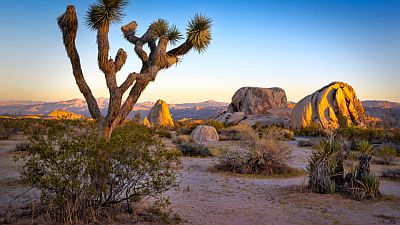
Yucca brevifolia), also called Joshua Tree, which is located in the park. We are in the southern part of the Mojave desert. The landscape is varied, sometimes rocky and sometimes sandy, and characterized by hills, plateaus and canyons. There are also oases, due to the water that emerges from the subsoil, pushed by seismic faults.
There are also some
mountain ranges. Along the southwest border of the park we find the
Little San Bernardino Mountains, where there is the highest peak, Mount Quail, 1,771 meters (5,810 feet) high. In the northeast we find the Coxcomb Mountains, and in the south the Cottonwood Mountains and the Eagle Mountains.
Keys View, a famous vantage point, is located at 1,580 meters (5,185 ft).
In general, in the lower areas of the park, the altitude is about 500 meters (1,650 ft), even if locally drops to about 200 meters (650 ft).
Just outside the park are the cities of Desert Hot Springs, Yucca Valley, Joshua Tree, and Twentynine Palms. In addition, there is a city, Pioneertown, used as a set for western movies, at 1,200 meters (3,900 ft) above sea level.
In
winter, generally the days are mild and sunny, but at night it can be cold. On the
coldest nights of the year, the temperature generally drops slightly below freezing. Occasionally, there may be short cold periods, in which the temperature remains below 10 °C (50 °F) even during the day. Above 1,000 meters (3,300 ft), of course, it gets cold more often, and in the worst moments it can drop below -10 °C (14 °F). In the mountains, it can also snow.
Below 1,000 meters (3,300 ft), the
summer is torrid, and in the worst moments, the temperature can exceed 45 °C (113 °F).
In the town of Joshua Tree, located at 800 meters (2,600 feet) above sea level, the
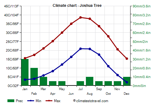
average temperature of the coldest month (December) is of 8.7 °C (47.6 °F), that of the warmest month (July) is of 29.8 °C (85.6 °F). On average, there are 130 days with a maximum temperature equal to or above 32 °C (90 °F), and that usually happens from April through October. Here are the average temperatures.
Joshua Tree - Average temperatures (1991-2020) |
| Month | Min | Max | Mean |
|---|
| January | 3.4 | 15.6 | 9.5 |
|---|
| February | 3.9 | 17.4 | 10.7 |
|---|
| March | 5.8 | 21.1 | 13.5 |
|---|
| April | 8.3 | 25.2 | 16.8 |
|---|
| May | 12 | 30.1 | 21 |
|---|
| June | 16.3 | 35.1 | 25.7 |
|---|
| July | 20.9 | 38.6 | 29.8 |
|---|
| August | 20.8 | 37.9 | 29.4 |
|---|
| September | 17.6 | 33.7 | 25.6 |
|---|
| October | 11.1 | 27.9 | 19.5 |
|---|
| November | 6.1 | 20.6 | 13.3 |
|---|
| December | 2 | 15.3 | 8.7 |
|---|
| Year | 10.7 | 26.6 | 18.6 |
|---|
in the park is scarce, and in Joshua Tree, it amounts to 110 mm (4.4 in) per year. However, given the nature of the terrain, occasional flash floods can occur. Even if the summer is dry, occasional short thunderstorms can occur, when humid air masses arrive from the Gulf of California and the Imperial Valley. Here is the average rainfall.
Joshua Tree - Average precipitation| Month | Days |
|---|
| January | 30 | 3 |
|---|
| February | 20 | 3 |
|---|
| March | 10 | 2 |
|---|
| April | 5 | 2 |
|---|
| May | 5 | 0 |
|---|
| June | 0 | 0 |
|---|
| July | 5 | 2 |
|---|
| August | 10 | 2 |
|---|
| September | 5 | 2 |
|---|
| October | 5 | 1 |
|---|
| November | 5 | 2 |
|---|
| December | 10 | 4 |
|---|
| Year | 110 | 22 |
|---|

Best Time
To visit Joshua Tree National Park, you can choose the period from
October to April, since in summer it is very hot, and some trails are closed. In particular, you can choose the periods from mid-March to mid-April and from mid-October to mid-November. In spring, you can watch flowers (if you are lucky, you can also hope to see cacti in bloom), and also migratory birds.
In
winter, it can be cold, especially on mountain roads, and sometimes it can rain (and snow in the mountains). However, in good weather, you can also choose winter.
If you travel in the summer, you need to protect yourself from the sun (with a hat and sunglasses), and bring supplies of food and liquids, water or better yet sports drinks (with hot and dry air, it is easy to dehydrate, and there are no refreshment points).
In addition to cacti spines (even those that seem soft...), you have to be careful with animals such as snakes, scorpions and spiders, and also to bees near their hives.
Since cell phones and GPS do not always work well, it is better to bring a map and a compass.