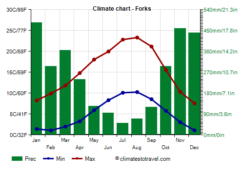
Select units of measurement for the temperature and rainfall tables (metric or imperial).
Average weather, temperature, rainfall, sunshine hours

The climate of Forks is
sub-oceanic, with quite mild, very rainy winters and mild, quite sunny summers.
The town is located in the northwestern part of
Washington state, 18 km (11 miles) away from the ocean, and west of the Olympic Mountains.
Precipitation amounts to 3,045 millimeters (119.9 inches) per year. We are in a particularly humid and rainy area. In the contiguous United States, there are no other lowland areas that are so rainy: you have to go to Alaska or Hawaii.
At Quillayute airport, there are on average around 1,530
sunshine hours per year. We are probably in the dullest lowland area of the United States. Here are the average sunshine hours per day.
Although the temperatures are not usually very low, wind, humidity and rain exacerbate the feeling of cold.

Occasionally in
winter, sometimes even as early as November, there may be cold spells, in which the temperature can drop down to -7/-8 °C (18/19 °F) or even below.
Given the generally mild climate, snowfalls are rare, however, a more abundant snowfall than usual can occasionally occur. In a year, 20 cm (8 in) of snow fall.
In spring, the temperature rises slowly, and in May, there are still very cool, rainy days. In late spring and summer, fog can form at night and in the early morning.
In
summer, there are many nice days, although it rarely gets hot. On the hottest days of the year, the temperature can reach 32/33 °C, but it may not even reach 30 °C (86 °F) for a whole month. However, in August 1981, it reached 39 °C (102 °F), while during the exceptional heat wave of late June 2021, it reached 43 °C (110 °F).
On the Pacific coast (see La Push), the
sea temperature ranges between 9 °C (48 °F) and 14.5 °C (58 °F). So, it is cold all year round.
Best Time
The best time to visit Forks is summer, especially in July and August, since it is the mildest, driest and sunniest period of the year. June and September are also acceptable months.
La Push - Climate data
In Forks, the
average temperature of the coldest month (December) is of
4.3 °C, that of the warmest month (August) is of
16.8 °C. Here are the average temperatures.
Forks - Average temperatures (1991-2020) |
| Month | Min | Max | Mean |
|---|
| January | 1.4 | 8.3 | 4.9 |
|---|
| February | 1.1 | 9.9 | 5.5 |
|---|
| March | 2 | 11.8 | 6.9 |
|---|
| April | 3.3 | 14.8 | 9.1 |
|---|
| May | 5.9 | 18.1 | 12 |
|---|
| June | 8.3 | 20 | 14.2 |
|---|
| July | 10.1 | 22.8 | 16.5 |
|---|
| August | 10.3 | 23.3 | 16.8 |
|---|
| September | 8.6 | 21.2 | 14.9 |
|---|
| October | 5.8 | 15.6 | 10.7 |
|---|
| November | 3.1 | 10.3 | 6.7 |
|---|
| December | 1.1 | 7.6 | 4.3 |
|---|
| Year | 5.1 | 15.3 | 10.2 |
|---|
amounts to
3045 millimeters per year: it is therefore very abundant. It ranges from
50 millimeters in the driest month (July) to
485 millimeters in the wettest one (January). Here is the average precipitation.
Forks - Average precipitation| Month | Days |
|---|
| January | 485 | 23 |
|---|
| February | 295 | 20 |
|---|
| March | 365 | 23 |
|---|
| April | 240 | 20 |
|---|
| May | 125 | 16 |
|---|
| June | 95 | 16 |
|---|
| July | 50 | 10 |
|---|
| August | 70 | 9 |
|---|
| September | 120 | 12 |
|---|
| October | 295 | 19 |
|---|
| November | 460 | 23 |
|---|
| December | 440 | 24 |
|---|
| Year | 3045 | 215 |
|---|