Select units of measurement for the temperature and rainfall tables (metric or imperial).
Average weather, temperature, rainfall, sunshine hours

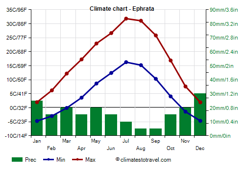
The climate of Ephrata is
arid continental, with very cold, relatively rainy winters and hot, sunny summers.
The town is located in the central part of the state of
Washington, at almost 400 meters (1,300 ft) above sea level, in an area where the waters of the Columbia River are used to irrigate an otherwise very arid ground.
During the
winter, sometimes as early as in mid-November, cold spells can occur, in which the temperature drops to -20 °C (-4 °F) or below. The temperature dropped to -31 °C (-24 °F) in January 1950, and to -28.5 °C (-19.5 °F) in February 1985 and in February 1996.
Snowfalls are quite frequent, but generally not abundant. On average, 47 cm (18.5 in) of snow fall per year, which given the cold winter it's not much.
In
summer, very hot days can occur, when the temperature can reach 40 °C (104 °F). During the exceptional heat wave of late June 2021, the temperature reached 47 °C (116 °F).

Best Time
The best times to visit Ephrata are spring and autumn, and in particular the months of May and September, to avoid both the winter cold and the summer heat.
Ephrata - Climate data
In Ephrata, the
average temperature of the coldest month (December) is of
-1.4 °C, that of the warmest month (July) is of
24.1 °C. Here are the average temperatures.
Ephrata - Average temperatures (1991-2020) |
| Month | Min | Max | Mean |
|---|
| January | -4.7 | 2 | -1.4 |
|---|
| February | -2.9 | 6.2 | 1.6 |
|---|
| March | -0.1 | 12.2 | 6.1 |
|---|
| April | 3.6 | 17.3 | 10.4 |
|---|
| May | 8.7 | 22.9 | 15.8 |
|---|
| June | 12.4 | 26.7 | 19.6 |
|---|
| July | 16.3 | 31.8 | 24.1 |
|---|
| August | 15.2 | 31.1 | 23.1 |
|---|
| September | 10.3 | 25.8 | 18.1 |
|---|
| October | 4.1 | 16.9 | 10.5 |
|---|
| November | -1.4 | 7.6 | 3.1 |
|---|
| December | -4.7 | 1.9 | -1.4 |
|---|
| Year | 4.8 | 16.9 | 10.85 |
|---|
amounts to
195 millimeters per year: it is therefore at a desert level. It ranges from
5 millimeters in the driest months (August, September) to
30 millimeters in the wettest one (December). Here is the average precipitation.
Ephrata - Average precipitation| Month | Days |
|---|
| January | 25 | 9 |
|---|
| February | 15 | 6 |
|---|
| March | 20 | 7 |
|---|
| April | 15 | 6 |
|---|
| May | 20 | 6 |
|---|
| June | 15 | 5 |
|---|
| July | 10 | 2 |
|---|
| August | 5 | 2 |
|---|
| September | 5 | 3 |
|---|
| October | 15 | 6 |
|---|
| November | 20 | 9 |
|---|
| December | 30 | 10 |
|---|
| Year | 195 | 71 |
|---|