Select units of measurement for the temperature and rainfall tables (metric or imperial).
Average weather, temperature, rainfall, sunshine hours

The climate of Crater Lake is
moderately continental, with cold, snowy winters and mild, sunny summers during the day, but with cold nights.
The national park is located in
Oregon, in the Cascade Range.
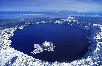
The lake, whose banks are located at 1,900 meters (6,200 feet) above sea level, was formed by the rain and snow that filled the caldera of Mount Mazama, a volcano that collapsed after an eruption that took place 7,700 years ago. The lake is 592 meters (1,942 ft) deep, and is therefore the deepest in the United States, and the second in North America after the Great Bear Lake. Before the eruption, Mount Mazama was 3,700 meters (12,100 ft) high. Today, the highest point in the area is Mount Scott, 2,723 meters (8,934 ft) high.
In
winter, cold waves are possible, during which the temperature can drop to -20 °C (-4 °F) or even below. Snowfalls are very abundant: in an average year, almost 13 meters (505 inches) of snow fall. Usually, it snows from mid-October to mid-May. The accumulated snow is so high that it generally only melts in July.
In
summer, the days are mild, and sometimes even hot, but at night it gets cold, and sometimes the temperature can drop below freezing.

Best Time
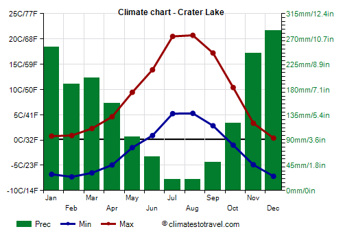
The best time to visit Crater Lake National Park is the summer, and in particular the months of July and August, which are the mildest and driest of the year.
Crater Lake - Climate data
In Crater Lake, the
average temperature of the coldest month (December) is of
-3,4 °C, that of the warmest month (August) is of
13 °C. Here are the average temperatures.
Crater Lake - Average temperatures (1991-2020) |
| Month | Min | Max | Mean |
|---|
| January | -6,8 | 0,8 | -3 |
|---|
| February | -7,3 | 0,9 | -3,2 |
|---|
| March | -6,5 | 2,3 | -2,1 |
|---|
| April | -4,9 | 4,6 | -0,2 |
|---|
| May | -1,5 | 9,4 | 4 |
|---|
| June | 0,9 | 13,9 | 7,4 |
|---|
| July | 5,2 | 20,5 | 12,9 |
|---|
| August | 5,3 | 20,7 | 13 |
|---|
| September | 2,8 | 17,2 | 10 |
|---|
| October | -1 | 10,4 | 4,7 |
|---|
| November | -4,9 | 3,3 | -0,8 |
|---|
| December | -7,2 | 0,4 | -3,4 |
|---|
| Year | -2,1 | 8,8 | 3,3 |
|---|
amounts to
1695 millimeters per year: it is therefore abundant. It ranges from
20 millimeters in the driest months (July, August) to
285 millimeters in the wettest one (December). Here is the average precipitation.
Crater Lake - Average precipitation| Month | Days |
|---|
| January | 255 | 18 |
|---|
| February | 190 | 17 |
|---|
| March | 200 | 18 |
|---|
| April | 155 | 16 |
|---|
| May | 95 | 12 |
|---|
| June | 60 | 7 |
|---|
| July | 20 | 4 |
|---|
| August | 20 | 4 |
|---|
| September | 50 | 5 |
|---|
| October | 120 | 11 |
|---|
| November | 245 | 17 |
|---|
| December | 285 | 18 |
|---|
| Year | 1695 | 146 |
|---|
There are on average around 2745
sunshine hours per year. Here are the average hours of sunshine per day.
Crater Lake - Sunshine hours| Month | Average | Total |
|---|
| January | 4 | 125 |
|---|
| February | 5 | 145 |
|---|
| March | 7 | 215 |
|---|
| April | 8 | 240 |
|---|
| May | 10 | 310 |
|---|
| June | 11 | 330 |
|---|
| July | 12 | 370 |
|---|
| August | 11 | 340 |
|---|
| September | 9 | 270 |
|---|
| October | 7 | 215 |
|---|
| November | 3 | 90 |
|---|
| December | 3 | 95 |
|---|
| Year | 7,5 | 2745 |
|---|