Select units of measurement for the temperature and rainfall tables (metric or imperial).
Average weather, temperature, rainfall, sunshine hours
In most of the the Big Bend National Park, the climate is
arid subtropical, with quite mild winters (but with cold nights) and very hot summers.
The park is located in southwest Texas. We are in the Chihuahuan desert, where some rain can occur from July to September, and sometimes, a particularly intense thunderstorm.
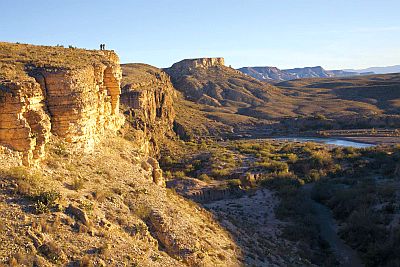
Most of the park is located at an altitude of 800/1,000 meters (2,600/3,300 feet), but there are also lower areas (the southern part, along the Rio Grande river that marks the border with Mexico, where the altitude drops below 600 meters or 2,000 feet), and higher areas (in the center, the Chisos mountains are found, which culminate in Emory Peak, 2,385 meters (7,824 ft) high, and where the temperatures are much lower).
At the lowest altitudes,
winter is generally mild, at least during the day, but sometimes there can be cold spells, during which the temperature can drop to -10 °C (14 °F).
In
summer it normally reaches 40 °C (104 °F).
At high altitudes, at the Chisos Mountain Lodge, which is located at 1,600 meters (5,250 ft), and even more so on the mountain peaks above 2,000 meters (6,600 ft), it is easier for snow and frost to occur in winter.
From time to time, the park can be reached by the remnants of a
hurricane, coming from the Gulf of Mexico or the Pacific. In general, hurricanes weaken when they penetrate inland, however, they can still bring abundant rains. The hurricane season runs from June to November, although they are more likely from August to October, with a peak in September.

At
Persimmon Gap, 900 meters (2,950 ft) above sea level, the
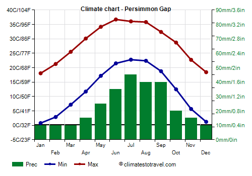
average temperature of the coldest month (January) is of 9.4 °C (49 °F), that of the warmest month (July) is of 29.4 °C (85 °F). On average, there are 38 days on which the minimum temperature is equal to or below freezing, and that usually happens from November through March. Besides, there are 49 days with a maximum temperature equal to or above 37.8 °C (100 °F), and that usually happens from April through September. Here are the average temperatures.
Persimmon Gap - Average temperatures (1991-2020) |
| Month | Min | Max | Mean |
|---|
| January | 0.8 | 18.1 | 9.4 |
|---|
| February | 2.9 | 21.3 | 12.1 |
|---|
| March | 7.2 | 25.5 | 16.3 |
|---|
| April | 11.7 | 30.1 | 20.9 |
|---|
| May | 17.2 | 34.2 | 25.7 |
|---|
| June | 21.5 | 36.7 | 29.1 |
|---|
| July | 22.8 | 36.1 | 29.4 |
|---|
| August | 22.4 | 35.8 | 29.1 |
|---|
| September | 18.8 | 32.4 | 25.6 |
|---|
| October | 12.5 | 28.7 | 20.6 |
|---|
| November | 5.7 | 22.7 | 14.2 |
|---|
| December | 1.2 | 18.4 | 9.8 |
|---|
| Year | 12.1 | 28.4 | 20.2 |
|---|
amounts to 275 millimeters (10.8 inches) per year: it is therefore scarce. It ranges from 10 mm (0.4 in) in the driest months (from December to March) to 45 mm (1.8 in) in the wettest (July). Here is the average precipitation.
Persimmon Gap - Average precipitation| Month | Days |
|---|
| January | 10 | 3 |
|---|
| February | 10 | 2 |
|---|
| March | 10 | 2 |
|---|
| April | 15 | 2 |
|---|
| May | 25 | 5 |
|---|
| June | 35 | 5 |
|---|
| July | 45 | 5 |
|---|
| August | 40 | 6 |
|---|
| September | 40 | 5 |
|---|
| October | 20 | 4 |
|---|
| November | 15 | 3 |
|---|
| December | 10 | 3 |
|---|
| Year | 275 | 46 |
|---|

Best Time
To visit the Big Bend national park you can choose spring and autumn, to avoid the winter cold as well as the summer heat, for example, from mid-March to mid-April and from mid-October to mid-November.
Return to the climate of
Texas.