Select units of measurement for the temperature and rainfall tables (metric or imperial).
Average weather, temperature, rainfall, sunshine hours
In much of Alabama, the climate is
humid subtropical, with mild, rainy winters, during which short cold spells can occur, and hot, muggy summers, with many hours of sunshine but also with rains and thunderstorms.
In the north, along the Tennessee River (see Huntsville, Florence, Decatur, Scottsboro), where the winter is a bit colder, the climate can be defined as
temperate.
Alabama is a state in the southeastern United States and has an area of 131,426 sq km (50,744 sq mi). It borders Mississippi, Tennessee, Georgia and Florida, while in the south, there is a coastal stretch of about 90 km (55 mi) that overlooks the Gulf of Mexico.
The state is largely occupied by plains, although there are hills in the center-north. The highest point is Mount Chehaha, 735 meters (2,411 feet) high.
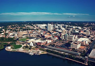
The capital is Montgomery, while the largest city is Birmingham.

The Alabama
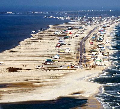
River, which passes near the capital, joins the Tombigbee River in the south of the state, creating the Mobile River, which flows into the sea at the city of the same name. Mobile overlooks a bay, south of which are a barrier
island, Dauphin Island, and a peninsula, Mobile Point. Further east, we find islands, inland bays (such as Wolf Bay and Perdido Bay) and peninsulas. On the coast, near towns like Golf Shores and Orange Beach, there are long beaches.
The state extends from 30 to 35 degrees north latitude, and often receives warm, humid currents from the Gulf of Mexico which, however, collide with colder, drier air masses from the west, and sometimes even from Canada.
The
clash of air masses can cause sudden changes in temperature, thunderstorms (sometimes accompanied by hail) and abundant rainfall, except in summer, when sultry heat prevails, although thunderstorms can still break out.
In spring and early summer, generally from April to June, and more rarely in autumn,
tornadoes may develop, due to the collision of air masses. Alabama is located in a particularly endangered area, the so-called "Dixie Alley". The north is the most affected area, while the coast is the least affected.
At sea level, the average
temperature in January ranges from 6 °C (43 °F) in the north (see Huntsville) to 11 °C (52 °F) on the south coast and nearby (see Mobile), that of July is of 27.5 °C (81.5 °F) in the north and of 28/28.5 °C (82.5/83 °F) in the center-south. Here are the average temperatures in
Huntsville, which is located in the north of the state.
Huntsville - Average temperatures (1991-2020) |
| Month | Min | Max | Mean |
|---|
| January | 0.6 | 11.3 | 5.9 |
|---|
| February | 2.4 | 13.9 | 8.2 |
|---|
| March | 6.1 | 18.6 | 12.4 |
|---|
| April | 10.6 | 23.8 | 17.2 |
|---|
| May | 15.7 | 28.1 | 21.9 |
|---|
| June | 20 | 31.7 | 25.9 |
|---|
| July | 21.7 | 33.1 | 27.4 |
|---|
| August | 20.9 | 32.9 | 26.9 |
|---|
| September | 17.4 | 30.3 | 23.9 |
|---|
| October | 11 | 24.4 | 17.7 |
|---|
| November | 5.1 | 17.7 | 11.4 |
|---|
| December | 2.2 | 12.8 | 7.5 |
|---|
| Year | 11.2 | 23.3 | 17.2 |
|---|
Here are the average temperatures in
Mobile, which is located in the south, near the coast.
Mobile - Average temperatures (1991-2020) |
| Month | Min | Max | Mean |
|---|
| January | 4.8 | 16.4 | 10.6 |
|---|
| February | 6.9 | 18.7 | 12.8 |
|---|
| March | 10 | 22.1 | 16.1 |
|---|
| April | 13.3 | 25.4 | 19.4 |
|---|
| May | 17.7 | 29.4 | 23.5 |
|---|
| June | 21.6 | 31.9 | 26.7 |
|---|
| July | 22.8 | 32.7 | 27.8 |
|---|
| August | 22.7 | 32.7 | 27.7 |
|---|
| September | 20.4 | 30.8 | 25.6 |
|---|
| October | 14.6 | 26.5 | 20.5 |
|---|
| November | 8.7 | 21.2 | 15 |
|---|
| December | 6.1 | 17.5 | 11.8 |
|---|
| Year | 14.2 | 25.5 | 19.8 |
|---|
in Alabama is abundant, since it hovers around 1,300/1,400 millimeters (51/55 inches) per year in the center-north (see Birmingham), while in the south (see Mobile) it reaches 1,700 mm (56 in). There are no dry seasons, however the wettest seasons are winter and spring in the north, and summer in the south, due to afternoon thunderstorms but also to the contribution made by hurricanes and tropical storms (see below). Autumn is the least rainy season everywhere.
Here is the average precipitation in
Birmingham, located in the central-north of the state.
Birmingham - Average precipitation| Month | Days |
|---|
| January | 130 | 10 |
|---|
| February | 125 | 11 |
|---|
| March | 145 | 11 |
|---|
| April | 130 | 9 |
|---|
| May | 125 | 10 |
|---|
| June | 120 | 11 |
|---|
| July | 140 | 12 |
|---|
| August | 110 | 11 |
|---|
| September | 100 | 7 |
|---|
| October | 85 | 7 |
|---|
| November | 105 | 8 |
|---|
| December | 125 | 10 |
|---|
| Year | 1440 | 118 |
|---|
Even though the winter is mild, there may be
cold waves, usually of short duration, more intense in the north. On the coldest days of the year, the temperature generally drops to -12/-13 °C (8/10 °F) in the north and to -6/-7 °C (19/21 °F) in the south. More rarely, the temperature can drop below -20 °C (-4 °F) in the north and below -10 °C (14 °F) in the south.
Snow in Alabama is quite rare in the north and very rare in the south. On average, 6 cm (2.3 in) of snow fall per year in Huntsville, 4 cm (1.6 in) in Birmingham, and just half a centimeter (0.2 in) in Mobile.

Alabama is a
sunny state, although not as sunny as Florida or the deserts of the southwest. On average, there are 2,600/2,700 hours of sunshine per year. Here are the average hours of sunshine per day in
Montgomery.
Montgomery - Sunshine hours| Month | Average | Total |
|---|
| January | 5 | 155 |
|---|
| February | 6 | 165 |
|---|
| March | 7 | 220 |
|---|
| April | 8.5 | 250 |
|---|
| May | 8.5 | 265 |
|---|
| June | 8.5 | 260 |
|---|
| July | 8.5 | 260 |
|---|
| August | 8 | 250 |
|---|
| September | 7.5 | 225 |
|---|
| October | 7.5 | 230 |
|---|
| November | 5.5 | 170 |
|---|
| December | 5 | 155 |
|---|
| Year | 7.2 | 2610 |
|---|
The
sea temperature ranges between 17 °C (63 °F) and 30 °C (85 °F). The sea is warm enough for swimming from May to October or November, while in winter it is a bit cold. Here are the average sea temperatures near Mobile.
Mobile - Sea temperature| Month |
|---|
| January | 18 |
|---|
| February | 17 |
|---|
| March | 18.5 |
|---|
| April | 21 |
|---|
| May | 24.5 |
|---|
| June | 28 |
|---|
| July | 29.5 |
|---|
| August | 29.5 |
|---|
| September | 28.5 |
|---|
| October | 25 |
|---|
| November | 22"> |
|---|
| December | 19.5 |
|---|
| Year | 23.4 |
|---|
Hurricanes
Alabama is also exposed to the risk of
hurricanes coming from the Gulf of Mexico. The area most at risk is the coast, which can receive storm surges, moreover, hurricanes weaken when they penetrate inland, however, they can still bring abundant rainfall. Hurricane season runs from June to November, although they are more likely from August to October, with a peak in September.
The hurricane that caused the most severe damage in Alabama was Frederic in September 1979. After 2000, hurricanes that had a significant impact on the coast were Ivan in September 2004, Katrina in August 2005 (although it hit most directly Louisiana), Sally in September 2020, and Zeta at the end of October 2020.
Best Time
The best times to visit Alabama are
spring and autumn, to avoid the heat in summer and the possible cold spells in winter. In the center-north you can choose the months of April and October, while in the center-south you can choose the periods from mid-March to mid-April and from mid-October to mid-November.
However, in spring there is a greater risk of tornadoes, while in autumn there is a risk of hurricanes, especially on the coast.
See also the
temperatures by month.