Average weather, temperature, rainfall, sunshine hours
On the coast of the province of Murcia, called
Costa Cálida, located in southeastern Spain, between the Costa de Almería and the Costa Blanca, the climate is
Mediterranean, with mild, relatively rainy winters and hot, sunny summers.
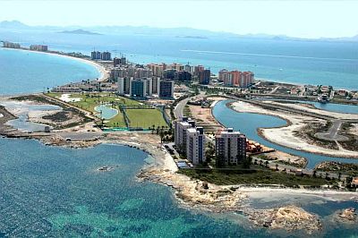
We find towns such as Cartagena, San Pedro del Pinatar, San Javier, Santiago de la Ribera, Águilas, Los Alcázares, and Mazarrón. There are tourist resort with golf courses, bays and natural harbors, islands and beaches where you can surf. There is also a large lagoon, called
Mar Menor, separated from the sea by a strip of sand (called
la Manga); inside the lagoon, there are five small islands.
In the southern part of the coast, we find the natural park of
Sierra de la Muela, Cabo Tiñoso y Roldán.

For example, in
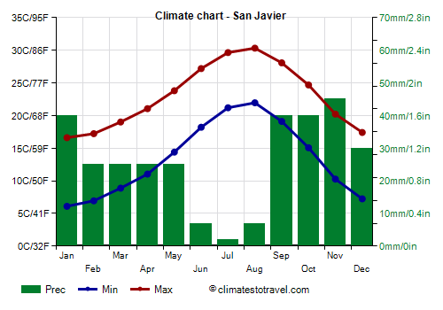
San Javier, the average temperature ranges from 11.5 °C (52.5 °F) in January to 26 °C (79 °F) in August.
The
rains are scarce, around 300 millimeters (12 inches) per year. However, although it is an arid area, the coast of the province of Murcia may on occasion be affected by heavy rains, which can lead to flooding, especially in autumn.
In San Javier, only 310 mm (12.2 in) of rain fall per year; you can notice the low number of rainy days.
The amount of
sunshine on the Costa Cálida is very good in summer, when clear skies prevail, it is good in spring and autumn and decent even in winter.
On average, in San Javier there are 2,650 sunshine hours per year.
The
sea on the Costa Cálida is warm enough for swimming from July to September, when it reaches 23/25 °C (73/77 °F); it remains cool until June.
The seasons
Winter, from December to February, is a mild season, and it's characterized by sunny periods alternating with periods of bad weather, with wind and rain, which, however, are quite rare.
There is a good number of sunny days, with daytime temperatures reaching 18/20 °C (64/68 °F) even in winter. With the wind from Africa, it can instead exceed 20 °C (68 °F).
Very
cold days are rare, however, there may be periods, usually short, in which the night temperature drops to freezing (0 °C or 32 °F) or a little below, while it fluctuates around 8/10 °C (46/50 °F) during the day. In these periods, the cold is felt, also because houses are often poorly heated.
Generally, on the coldest nights of the year, the temperature drops to 0 °C (32 °F) or slightly below.
Snow on the Costa Cálida is a very rare phenomenon, but not impossible. On January 27, 2005, after 60 years, it snowed in Cape Palos, a place more exposed to the north wind than the rest of the coast. In January 2017, however, it snowed in almost the entire province of Murcia, including some coastal areas such as Cartagena and the Mar Menor.
The
summer, from June to mid-September, is hot and sunny. During the day the breeze blows, providing some relief, but the nights are muggy. There can also be very hot periods, usually of short duration, in which the temperature reaches 35/36 °C (95/97 °F). More rarely, it can reach higher values, around 38/40 °C (100/104 °F).

Best Time
The
best time for a beach holiday in the Costa Cálida is the summer, from June to August. The sea temperature is comfortable enough from July to September, although by September, which overall is still a good month (especially in the first half), the first Atlantic disturbances begin to occur. May and June are sunny months, but the sea is still a bit cool, especially in May, when it is actually a bit cold.
Even though good weather is not always guaranteed,
spring and autumn are ideal for visiting the city of
Murcia and for excursions to the other cities of the interior (see Lorca), since the summer can be very hot.