Select units of measurement for the temperature and rainfall tables (metric or imperial).
Average weather, temperature, rainfall, sunshine hours

The climate of the Kermadec Islands is
humid subtropical, with very mild winters (June to August) and warm, rainy summers (December to March). Being in the southern hemisphere, the seasons are reversed compared to the northern hemisphere.
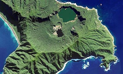
The Kermadec archipelago (Rangitāhua in Maori) is made up of small islands located in the Pacific Ocean, between 29 and 31 degrees south latitude. The main islands are Raoul (also called Sunday Island), Macauley and Curtis. The islands are not flat, but are covered by hills, the highest of which is located on Raoul Island, and reaches 516 meters (1,693 feet).
Raoul Island, a volcanic island located more than 950 kilometers (600 miles) north-east of the North Island of New Zealand and at 29 degrees south latitude, is mild and rainy. The average
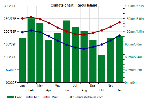
temperature ranges from 16 °C (61 °F) in August to 23 °C (73.5 °F) in February. In winter, from June to September, there can be cool periods, with lows of 9/10 °C (48/50 °F) and highs of 16/17 °C (61/63 °F). In summer, the heat records are 29/30 °C (84/86 °F) between December and March.
Here are the average temperatures.
Raoul Island - Average temperatures (1981-2010) |
| Month | Min | Max | Mean |
|---|
| January | 19.7 | 25.1 | 22.4 |
|---|
| February | 20.4 | 25.6 | 23 |
|---|
| March | 19.8 | 24.8 | 22.3 |
|---|
| April | 18.1 | 23.4 | 20.8 |
|---|
| May | 16.4 | 21.5 | 19 |
|---|
| June | 14.8 | 20 | 17.4 |
|---|
| July | 13.7 | 19 | 16.4 |
|---|
| August | 13.2 | 18.8 | 16 |
|---|
| September | 13.9 | 19.5 | 16.7 |
|---|
| October | 14.9 | 20.4 | 17.6 |
|---|
| November | 16.5 | 21.9 | 19.2 |
|---|
| December | 18.4 | 23.6 | 21 |
|---|
| Year | 16.6 | 21.9 | 19.25 |
|---|
On average, 1,385 mm (54.5 in) of
rain fall per year. The rains are well distributed throughout the year, although they are more frequent in winter and less frequent between spring and early summer, from October to January. Here is the average rainfall.
Raoul Island - Average precipitation| Month | Days |
|---|
| January | 105 | 8 |
|---|
| February | 150 | 10 |
|---|
| March | 140 | 11 |
|---|
| April | 100 | 12 |
|---|
| May | 115 | 12 |
|---|
| June | 145 | 13 |
|---|
| July | 130 | 14 |
|---|
| August | 120 | 12 |
|---|
| September | 100 | 11 |
|---|
| October | 65 | 9 |
|---|
| November | 105 | 8 |
|---|
| December | 110 | 8 |
|---|
| Year | 1385 | 130 |
|---|
Despite the frequent rains, the amount of
sunshine is quite good, in fact there are almost 2,400 hours of sunshine a year. Here are the average sunshine hours per day.
Raoul Island - Sunshine hours| Month | Average | Total |
|---|
| January | 9 | 275 |
|---|
| February | 8.5 | 245 |
|---|
| March | 6.5 | 200 |
|---|
| April | 5.5 | 170 |
|---|
| May | 5 | 150 |
|---|
| June | 4.5 | 130 |
|---|
| July | 4.5 | 145 |
|---|
| August | 5.5 | 170 |
|---|
| September | 6.5 | 200 |
|---|
| October | 7.5 | 230 |
|---|
| November | 7.5 | 220 |
|---|
| December | 8.5 | 260 |
|---|
| Year | 6.5 | 2390 |
|---|
The temperature of the
sea is quite warm from January to April, while it becomes very cool from July to October.
Raoul Island - Sea temperature| Month |
|---|
| January | 23.5 |
|---|
| February | 24 |
|---|
| March | 23.5 |
|---|
| April | 23 |
|---|
| May | 21.5 |
|---|
| June | 20.5 |
|---|
| July | 19.5 |
|---|
| August | 19 |
|---|
| September | 19 |
|---|
| October | 19.5 |
|---|
| November | 21"> |
|---|
| December | 22 |
|---|
| Year | 21.3 |
|---|
The Kermadec Islands are not exactly in the path of
tropical cyclones, but sometimes one of them can leave the tropical belt and head south, passing over the islands before weakening in the colder seas of the south. This happens from November to April, but more often from January to March.

Best Time
To visit the Kermadec Islands you can choose the summer, from December to March, as it is the warmest and sunniest period of the year. It must be said that the rains are quite frequent, moreover, a tropical cyclone (or its remnants) can sometimes pass. The least rainy period is from October to January. December is probably the best month.
From late August to early November, humpback whales cross the sea surrounding the islands, especially Raoul.
It should be remembered that in order to preserve pristine nature and biodiversity, only a small number of visitors are allowed access, and to visit them you need to obtain a permit. The islands are reached by boat with a 4/5 day trip.