Select units of measurement for the temperature and rainfall tables (metric or imperial).
Average weather, temperature, rainfall, sunshine hours

The climate of Talas is
semi-arid continental, with cold winters and relatively warm summers.
Talas is a city of 40,000 inhabitants, located in the region of the same name (of which it is the capital), in the north-west of Kyrgyzstan, in a mountain valley at 1,250 meters above sea level, and at 42 degrees north latitude.
The Talas River crosses the city and then heads west-north-west, where it crosses the more important city of
Taraz, today belonging to Kazakhstan, and which in the past was also known as Talas.
To the north, instead, near the border with Kazakhstan, there are
mountains, belonging to the western part of the Tian Shan, and which reach 3,700 meters (12,000 ft).
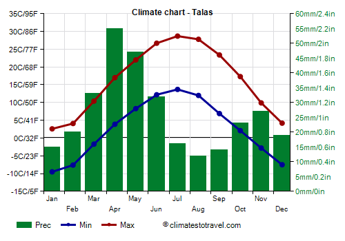
Precipitation is abundant but scarce, amounting to about 315 millimeters (12.5 inches) per year.
The rainiest season is spring, due to the clashes of air masses typical of this season. Sometimes there can be snowfall in April, and occasionally, as in 1993, even in May.
Winter, from December to February, is cold: the average temperature in January is around -3.5 °C (25.5 °F).
Fog can form during periods of stable weather.
At night the temperature almost always drops below freezing, but during the day, given that the temperature range is significant, during some periods the temperature can reach and exceed 10 °C (50 °F).
Due to the arid climate, snowfall is generally light.
During
cold waves, the temperature drops below -15 °C (5 °F) every year. Occasionally it can also drop below -30 °C (-22 °F). The coldest record is -35 °C (-31 °F), set in February 1951. More recently, the temperature reached -31.7 °C (-25.1 °F) in January 2012.
Summer, from June to August, is warm and sunny, although there is a possibility of rain and thunderstorms, usually of short duration. The average in July is around 21 °C (70 °F).
The altitude mitigates thr summer temperatures, moreover, the difference in temperature between night and day is often significant, so it can get cool at night.
However, there can be
heat waves, during which the temperature can exceed 35 °C (95 °F).
The highest record is 40.1 °C (104.2 °F), set in July 1983.
In July 2019, the average maximum was 32.8 °C (91 °F).
Talas - Climate data
In Talas, the
average temperature of the coldest month (January) is of
-3.4 °C, that of the warmest month (July) is of
21.2 °C. Here are the average temperatures.
Talas - Average temperatures (1991-2020) |
| Month | Min | Max | Mean |
|---|
| January | -9.5 | 2.6 | -3.4 |
|---|
| February | -7.6 | 4.1 | -1.8 |
|---|
| March | -1.7 | 10.4 | 4.4 |
|---|
| April | 3.9 | 17 | 10.4 |
|---|
| May | 8.3 | 22 | 15.2 |
|---|
| June | 12.2 | 26.7 | 19.4 |
|---|
| July | 13.7 | 28.7 | 21.2 |
|---|
| August | 12 | 27.8 | 19.9 |
|---|
| September | 6.9 | 23.4 | 15.2 |
|---|
| October | 2.1 | 17.3 | 9.7 |
|---|
| November | -2.8 | 9.9 | 3.6 |
|---|
| December | -7.5 | 4.2 | -1.6 |
|---|
| Year | 2.6 | 16.2 | 9.35 |
|---|
amounts to
315 millimeters per year: it is therefore scarce. It ranges from
12 millimeters in the driest month (August) to
55 millimeters in the wettest one (April). Here is the average precipitation.
Talas - Average precipitation| Month | Days |
|---|
| January | 15 | 4 |
|---|
| February | 20 | 5 |
|---|
| March | 33 | 7 |
|---|
| April | 55 | 8 |
|---|
| May | 47 | 8 |
|---|
| June | 32 | 5 |
|---|
| July | 16 | 4 |
|---|
| August | 12 | 2 |
|---|
| September | 14 | 2 |
|---|
| October | 23 | 5 |
|---|
| November | 27 | 5 |
|---|
| December | 19 | 4 |
|---|
| Year | 315 | 60 |
|---|