Select units of measurement for the temperature and rainfall tables (metric or imperial).
Average weather, temperature, rainfall, sunshine hours

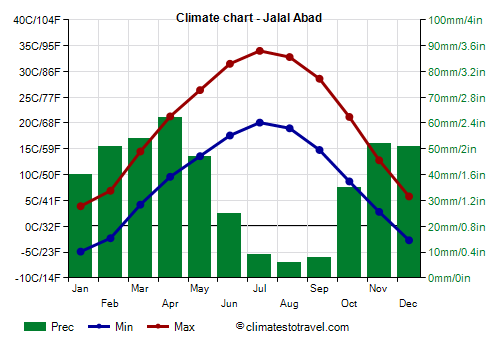
The climate of Jalal-Abad is
continental, with cold winters and very hot, sunny summers.
Jalal-Abad is a city of 130,000 inhabitants, located in the western part of Kyrgyzstan, in the homonymous region (of which it is the capital), at 775 meters above sea level, in the north-eastern part of the Fergana Valley (most of which belongs to Uzbekistan), and at almost 41 degrees north latitude.
About 50 km (30 mi) to the north is Mount Babash-Ata, 4,428 meters (14,528 feet) high, belonging to the Tian Shan range.
Precipitation is not abundant, since it amounts to 440 millimeters per year, however, it is more abundant than in other cities of the Fergana Valley, due to the proximity of the mountains. It occurs mostly from November to May, while in summer it almost never rains.
The
winter, from December to February, is cold, with an average January temperature of around -0.5 °C (31 °F).
During periods of stable weather,
fog can form.
There are quite mild periods, during which the temperature can reach or exceed 10 °C (50 °F).
Precipitation is not abundant, however, snow can occur, as well as rain when the temperature rises above freezing.
During
cold waves, the temperature can drop to -15 °C (5 °F) or below, although this doesn't happen every year. The coldest record is -27.2 °C (-17 °F), set in January 1969. The last time the temperature dropped below -20 °C (-4 °F) was in January 2008, with -21 °C (-6 °F).
Summer, from June to August, is very hot and sunny. The average in July is 27 °C (80.5 °F).
On the hottest days, the temperature reaches or exceeds 38/40 °C (100/104 °F).
The highest record is 41.8 °C (107.2 °F), set in July 2013. In July 2019, the average maximum was 36.8 °C (98.2 °F).
Jalal Abad - Climate data
In Jalal Abad, the
average temperature of the coldest month (January) is of
-0.5 °C, that of the warmest month (July) is of
27 °C. Here are the average temperatures.
Jalal Abad - Average temperatures (1991-2020) |
| Month | Min | Max | Mean |
|---|
| January | -4.9 | 3.9 | -0.5 |
|---|
| February | -2.3 | 6.9 | 2.3 |
|---|
| March | 4.2 | 14.5 | 9.4 |
|---|
| April | 9.6 | 21.3 | 15.4 |
|---|
| May | 13.6 | 26.4 | 20 |
|---|
| June | 17.6 | 31.5 | 24.6 |
|---|
| July | 20.1 | 34 | 27 |
|---|
| August | 19 | 32.8 | 25.9 |
|---|
| September | 14.8 | 28.6 | 21.7 |
|---|
| October | 8.7 | 21.2 | 15 |
|---|
| November | 2.8 | 12.8 | 7.8 |
|---|
| December | -2.7 | 5.8 | 1.5 |
|---|
| Year | 8.4 | 20 | 14.2 |
|---|
amounts to
440 millimeters per year: it is therefore quite scarce. It ranges from
6 millimeters in the driest month (August) to
62 millimeters in the wettest one (April). Here is the average precipitation.
Jalal Abad - Average precipitation| Month | Days |
|---|
| January | 40 | 3 |
|---|
| February | 51 | 4 |
|---|
| March | 54 | 6 |
|---|
| April | 62 | 5 |
|---|
| May | 47 | 5 |
|---|
| June | 25 | 3 |
|---|
| July | 9 | 1 |
|---|
| August | 6 | 1 |
|---|
| September | 8 | 1 |
|---|
| October | 35 | 3 |
|---|
| November | 52 | 5 |
|---|
| December | 51 | 4 |
|---|
| Year | 440 | 40 |
|---|