Select units of measurement for the temperature and rainfall tables (metric or imperial).
Average weather, temperature, rainfall, sunshine hours

The climate of Almaty is
continental, with cold winters and hot summers.
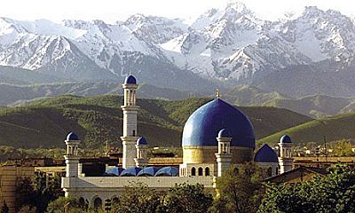
Almaty, formerly Alma-Ata, is a city located in southern Kazakhstan, in the region (oblys) of the same name, of which it is the capital, 800 meters (2,600 feet) above sea level and at 43 degrees north latitude.
With 2,250,000 inhabitants, Almaty is the most populous city in Kazakhstan, and until 1997 it was the capital of the country.
The city is located at the foot of the
Trans-Ili Alatau mountains (or Zailiyskiy Alatau), belonging to the Tian Shan chain, which are covered with perennial snow at high altitudes and whose highest peak is Pik Talgar, at 4,973 meters (16,316 ft).
About 30 km (18 mi) to the south, on the mountain ridge, is the border with Kyrgyzstan, and just to the south, Lake Ysyk-Köl (Issyk-Kul).
In the mountains, a few kilometers from Almaty, are
Medeu, a winter sports complex, at 1,700 meters (5,500 ft), and
Shymbulak (or Chimbulak), a ski resort, at 2,300 meters (7,500 ft).
About 150 kilometers (95 miles) to the east, in an arid area because it is further away from the mountains, is the
Charyn National Park, where a canyon is found.
 Almaty
Precipitation
Almaty
Precipitation is moderate, amounting to 670 millimeters (26.5 inches) per year. Due to the proximity of the mountains, Almaty is rainier than most of Kazakhstan, which is generally an arid country.
The rainiest season is spring, due to the clashes of air masses typical of this season. Sometimes there can be snowfall in April, and more rarely even in May.
Winter, from December to February, is cold: the average temperature in January is about -4 °C (25 °F).
However, unlike in northern Kazakhstan, southerly winds can bring mild air, so much so that temperatures can reach, and sometimes exceed, 10 °C (50 °F).
Fog can form during periods of stable weather.
Precipitation is not abundant, however, snow can occur, as well as rain when the temperature rises above freezing.
During
cold waves, the temperature can drop to -15 °C (5 °F) and even below. Occasionally it can even drop below -30 °C (-22 °F). The coldest record is -36.1 °C (-33 °F), set in February 1951. In February 1931, the daily average was -16.6 °C (2.1 °F).
Summer, from June to August, is hot and quite sunny, with possible rain and thunderstorms. The average for July is 24.5 °C (76 °F).
The altitude moderate the summer temperatures a bit, so much so that Almaty is not as hot as most other cities in southern Kazakhstan.
However, there may be
heat waves, during which the temperature can reach 37/38 °C (99/100 °F), and more rarely 40 °C (104 °F).
The hottest record is 43.5 °C (110.3 °F), set in July 1983.
Almaty - Climate data
In Almaty, the
average temperature of the coldest month (January) is of
-3.8 °C, that of the warmest month (July) is of
24.6 °C. Here are the average temperatures.
Almaty - Average temperatures (1991-2020) |
| Month | Min | Max | Mean |
|---|
| January | -8.1 | 0.5 | -3.8 |
|---|
| February | -6.2 | 2.8 | -1.7 |
|---|
| March | 0 | 10.1 | 5 |
|---|
| April | 6.8 | 17.9 | 12.4 |
|---|
| May | 11.5 | 22.9 | 17.2 |
|---|
| June | 16.4 | 27.9 | 22.2 |
|---|
| July | 18.6 | 30.5 | 24.6 |
|---|
| August | 17.4 | 29.7 | 23.5 |
|---|
| September | 12 | 24.5 | 18.2 |
|---|
| October | 5.4 | 16.9 | 11.1 |
|---|
| November | -0.9 | 8.2 | 3.6 |
|---|
| December | -6 | 2.1 | -2 |
|---|
| Year | 5.6 | 16.2 | 10.9 |
|---|
amounts to
675 millimeters per year: so, it is at an intermediate level. It ranges from
27.8 millimeters in the driest month (September) to
112.4 millimeters in the wettest one (April). Here is the average precipitation.
Almaty - Average precipitation| Month | Days |
|---|
| January | 35 | 6 |
|---|
| February | 43 | 7 |
|---|
| March | 72 | 9 |
|---|
| April | 112 | 10 |
|---|
| May | 99 | 9 |
|---|
| June | 59 | 7 |
|---|
| July | 43 | 7 |
|---|
| August | 34 | 4 |
|---|
| September | 28 | 3 |
|---|
| October | 50 | 6 |
|---|
| November | 55 | 7 |
|---|
| December | 44 | 7 |
|---|
| Year | 675 | 83 |
|---|
There are on average around 2280
sunshine hours per year. Here are the average hours of sunshine per day.
Almaty - Sunshine hours| Month | Average | Total |
|---|
| January | 3.5 | 110 |
|---|
| February | 4 | 120 |
|---|
| March | 5.5 | 165 |
|---|
| April | 6.5 | 190 |
|---|
| May | 7.5 | 235 |
|---|
| June | 8.5 | 260 |
|---|
| July | 9 | 280 |
|---|
| August | 9 | 280 |
|---|
| September | 8 | 245 |
|---|
| October | 6 | 190 |
|---|
| November | 4 | 115 |
|---|
| December | 3 | 95 |
|---|
| Year | 6.2 | 2280 |
|---|
Almaty - Weather by month
Based on the period 1991-2020
January, the coldest month of the year, is generally a very cold month. The average temperature is of
-3.8 °C, with a minimum of
-8.1 °C and a maximum of
0.5 °C.

On the coldest nights of the month, the temperature usually drops to around
-17.5 °C. However, it dropped to
-27.8 °C in January 2018.

On the warmest days of the month, the temperature usually reaches around
10.5 °C. However, it reached
18.2 °C in January 2002.

Precipitation amounts to
34.7 mm, distributed over 6 days.
The day lasts on average 9 hours and 25 minutes.

There are on average 3.5 hours of sunshine per day. So, the sun shines 38% of the time.
The average humidity is 81%. Hence, the air is normally humid.
February is generally a very cold month. The average temperature is of
-1.7 °C, with a minimum of
-6.2 °C and a maximum of
2.8 °C.
On the coldest nights of the month, the temperature usually drops to around
-15 °C. However, it dropped to
-23.9 °C in February 1991.
On the warmest days of the month, the temperature usually reaches around
12.5 °C. However, it reached
21.9 °C in February 2016.
Precipitation amounts to
42.6 mm, distributed over 7 days.
The day lasts on average 10 hours and 30 minutes.
There are on average 4 hours of sunshine per day. So, the sun shines 40% of the time.
The average humidity is 80%. Hence, the air is normally humid.
March is generally a quite cold month. The average temperature is of
5 °C, with a minimum of
0 °C and a maximum of
10.1 °C.
On the coldest nights of the month, the temperature usually drops to around
-9 °C. However, it dropped to
-19.8 °C in March 1995.
On the warmest days of the month, the temperature usually reaches around
22 °C. However, it reached
29.8 °C in March 2018.
Precipitation amounts to
72.4 mm, distributed over 9 days.
The day lasts on average 12 hours and 0 minutes.
There are on average 5.5 hours of sunshine per day. So, the sun shines 44% of the time.
The average humidity is 71%. Hence, the air is normally humid.
April is generally a mild month. The average temperature is of
12.4 °C, with a minimum of
6.8 °C and a maximum of
17.9 °C.
On the coldest nights of the month, the temperature usually drops to around
-2 °C. However, it dropped to
-10.9 °C in April 2003.
On the warmest days of the month, the temperature usually reaches around
28.5 °C. However, it reached
33 °C in April 2020.
Precipitation amounts to
112.4 mm, distributed over 10 days.
The day lasts on average 13 hours and 25 minutes.
There are on average 6.5 hours of sunshine per day. So, the sun shines 47% of the time.
The average humidity is 60%.
May is generally a very mild month. The average temperature is of
17.2 °C, with a minimum of
11.5 °C and a maximum of
22.9 °C.
On the coldest nights of the month, the temperature usually drops to around
4 °C. However, it dropped to
-2.3 °C in May 1991.
On the warmest days of the month, the temperature usually reaches around
30.5 °C. However, it reached
35.8 °C in May 2014.
Precipitation amounts to
98.7 mm, distributed over 9 days.
The day lasts on average 14 hours and 40 minutes. So the days are long.
There are on average 7.5 hours of sunshine per day. So, the sun shines 52% of the time.
The average humidity is 56%.
June is generally a warm month. The average temperature is of
22.2 °C, with a minimum of
16.4 °C and a maximum of
27.9 °C.
On the coldest nights of the month, the temperature usually drops to around
10.5 °C. However, it dropped to
5.3 °C in June 1999.
On the warmest days of the month, the temperature usually reaches around
34 °C. However, it reached
37.6 °C in June 2007.
Precipitation amounts to
59 mm, distributed over 7 days.
The day lasts on average 15 hours and 20 minutes. So the days are long. June 21, the summer solstice, is the longest day of the year in the Northern Hemisphere.
There are on average 8.5 hours of sunshine per day. So, the sun shines 57% of the time.
The average humidity is 50%.
July, the warmest month of the year, is generally a warm to hot month. The average temperature is of
24.6 °C, with a minimum of
18.6 °C and a maximum of
30.5 °C.
On the coldest nights of the month, the temperature usually drops to around
13 °C. However, it dropped to
8.3 °C in July 2003.
On the warmest days of the month, the temperature usually reaches around
37 °C. However, it reached
41.7 °C in July 1997.
Precipitation amounts to
42.9 mm, distributed over 7 days.
The day lasts on average 15 hours and 0 minutes. So the days are long.
There are on average 9 hours of sunshine per day. So, the sun shines 60% of the time.
The average humidity is 45%.
August is generally a warm to hot month. The average temperature is of
23.5 °C, with a minimum of
17.4 °C and a maximum of
29.7 °C.
On the coldest nights of the month, the temperature usually drops to around
10.5 °C. However, it dropped to
4.8 °C in August 1996.
On the warmest days of the month, the temperature usually reaches around
36.5 °C. However, it reached
39.7 °C in August 2002.
Precipitation amounts to
33.5 mm, distributed over 4 days.
The day lasts on average 13 hours and 55 minutes.
There are on average 9 hours of sunshine per day. So, the sun shines 64% of the time.
The average humidity is 44%.
September is generally a warm month. The average temperature is of
18.2 °C, with a minimum of
12 °C and a maximum of
24.5 °C.
On the coldest nights of the month, the temperature usually drops to around
4 °C. However, it dropped to
-0.7 °C in September 2000.
On the warmest days of the month, the temperature usually reaches around
33 °C. However, it reached
38.1 °C in September 1998.
Precipitation amounts to
27.8 mm, distributed over 3 days.
The day lasts on average 12 hours and 30 minutes.
There are on average 8 hours of sunshine per day. So, the sun shines 65% of the time.
The average humidity is 47%.
October is generally a mild month. The average temperature is of
11.1 °C, with a minimum of
5.4 °C and a maximum of
16.9 °C.
On the coldest nights of the month, the temperature usually drops to around
-2 °C. However, it dropped to
-8.9 °C in October 1993.
On the warmest days of the month, the temperature usually reaches around
26.5 °C. However, it reached
32.1 °C in October 2015.
Precipitation amounts to
49.8 mm, distributed over 6 days.
The day lasts on average 11 hours and 0 minutes.
There are on average 6 hours of sunshine per day. So, the sun shines 55% of the time.
The average humidity is 61%.
November is generally a cold month. The average temperature is of
3.6 °C, with a minimum of
-0.9 °C and a maximum of
8.2 °C.
On the coldest nights of the month, the temperature usually drops to around
-9 °C. However, it dropped to
-20 °C in November 1997.
On the warmest days of the month, the temperature usually reaches around
19.5 °C. However, it reached
26.5 °C in November 2017.
Precipitation amounts to
55.3 mm, distributed over 7 days.
The day lasts on average 9 hours and 40 minutes.
There are on average 4 hours of sunshine per day. So, the sun shines 40% of the time.
The average humidity is 76%. Hence, the air is normally humid.
December is generally a very cold month. The average temperature is of
-2 °C, with a minimum of
-6 °C and a maximum of
2.1 °C.
On the coldest nights of the month, the temperature usually drops to around
-15 °C. However, it dropped to
-24.2 °C in December 2001.
On the warmest days of the month, the temperature usually reaches around
12 °C. However, it reached
18.2 °C in December 2000.
Precipitation amounts to
44.3 mm, distributed over 7 days.
The day lasts on average 9 hours and 0 minutes. December 21, the winter solstice, is the shortest day of the year in the Northern Hemisphere.
There are on average 3 hours of sunshine per day. So, the sun shines 34% of the time.
The average humidity is 82%. Hence, the air is normally humid.