Select units of measurement for the temperature and rainfall tables (metric or imperial).
Average weather, temperature, rainfall, sunshine hours

In Trento, the capital of the province of the same name, in the Trentino-Alto Adige region, the climate is
semi-continental, with cold winters and hot summers.
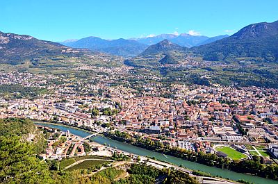
The city is located at 46 degrees north latitude, in the Adige River Valley, almost 200 meters (650 feet) above sea level. About 30 km (18 mi) to the southwest lies Lake Garda. To the north-west is the Paganella, a mountain group whose highest peak reaches 2,125 metres (6,971 ft).
 Winter
, from December to February, is cold, with cold air stagnating in the valley, especially in December and January. The sky is often cloudy, sometimes fog can form, and in any case, the sun can only be seen for a few hours a day because the city is surrounded by mountains.
Snow in Trento varies according to the year, however it is more abundant than in the Po valley, although the city remains dry with the wind from the north. In fact, in some situations with southerly winds, snow can be abundant. On average, about 50 cm (20 in) of snow fall per year. In January 1985, the snow reached one meter and 30 cm (51 in) in height.
Every now and then,
cold air masses from Eastern Europe can bring quite intense frosts, though the temperature rarely drops below -10 °C (14 °F). However, the temperature reached -15 °C (5 °F) in January 1985.
Summer, from June to August, is hot during the day, while nights are generally quite cool. In periods of good weather, the Adige River Valley gets hot, and poor wind conditions make the heat unpleasant.
In these periods, temperatures can reach 35/36 °C (95/97 °F) and sometimes even more. In August 2003, the temperature reached 40 °C (104 °F).
However, because of its northern location, the city is reached with some frequency by the tail of Atlantic fronts, which can bring a bit of cloudiness and even rain, while in the afternoon or in the evening, a thunderstorm may break out. For this reason, the amount of sunshine in summer is not very high.
Best Time
The
best period to visit Trento is that of spring and early summer, and in particular, from mid-April to mid-June. September, too, is a good month. However, you have to take into account some rainy days in both periods.
Summer can be hot, although some days can be acceptable, especially in June. In summer, and sometimes in May, sudden thunderstorms in the afternoon or evening must be put into account.
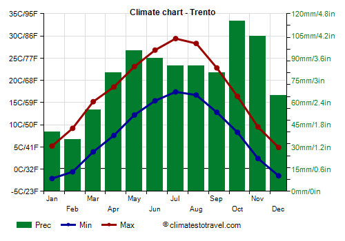
Trento - Climate data
In Trento, the
average temperature of the coldest month (January) is of
1.9 °C, that of the warmest month (July) is of
23.2 °C. Here are the average temperatures.
Trento - Average temperatures (1991-2020) |
| Month | Min | Max | Mean |
|---|
| January | -3.2 | 7 | 1.9 |
|---|
| February | -1.2 | 10.3 | 4.5 |
|---|
| March | 2.9 | 15.8 | 9.4 |
|---|
| April | 6.4 | 19.6 | 13 |
|---|
| May | 10.6 | 24 | 17.3 |
|---|
| June | 14.6 | 27.8 | 21.2 |
|---|
| July | 16.3 | 30 | 23.2 |
|---|
| August | 16.1 | 29.9 | 23 |
|---|
| September | 11.9 | 24.8 | 18.4 |
|---|
| October | 7.4 | 18.7 | 13.1 |
|---|
| November | 1.9 | 11.9 | 6.9 |
|---|
| December | -2.7 | 6.9 | 2.1 |
|---|
| Year | 6.8 | 18.9 | 12.85 |
|---|
amounts to
935 millimeters per year: so, it is at an intermediate level. It ranges from
35 millimeters in the driest month (February) to
115 millimeters in the wettest one (October). Here is the average precipitation.
Trento - Average precipitation| Month | Days |
|---|
| January | 40 | 4 |
|---|
| February | 35 | 3 |
|---|
| March | 55 | 6 |
|---|
| April | 80 | 8 |
|---|
| May | 95 | 10 |
|---|
| June | 90 | 10 |
|---|
| July | 85 | 8 |
|---|
| August | 85 | 8 |
|---|
| September | 80 | 7 |
|---|
| October | 115 | 8 |
|---|
| November | 105 | 7 |
|---|
| December | 65 | 6 |
|---|
| Year | 935 | 84 |
|---|