Select units of measurement for the temperature and rainfall tables (metric or imperial).
Average weather, temperature, rainfall, sunshine hours
In the Valle d'Aosta (Aosta Valley), the smallest Italian region, located in the north-west of the country, on the border with France and Switzerland and without plains, the climate varies according to the
altitude, and it is moderately continental at lower altitudes, while it becomes alpine at high altitudes.
The main valley, where the capital, Aosta, is located, is crossed by the Dora Baltea river.
In the valleys, the
föhn can blow, the wind that comes down from the mountains and brings clear skies, dry air and high temperatures.
Precipitation varies according to the altitude and the orientation of the valleys. In the valleys stretching from west to east, such as the main one, rainfall is not abundant, so much so that it does not reach 600 millimeters (23.5 inches) per year.
The mildest part of the region is the south-eastern one, in the lowest part of the valley (see Pont-Saint-Martin, Donnas), located just above 300 meters (985 feet) above sea level.
In
Donnas, located at an altitude of 340 meters (1,115 ft) and somewhat emphatically called the "Nice of Aosta Valley", the average temperature ranges from 3.5 °C (38.5 °F) in January to 23 °C (73.5 °F) in July. On the other hand, as the city is almost outside the valley and exposed to southerly winds, precipitation is quite abundant, 965 mm (38 in) per year. Here are the average temperatures.
Donnas - Average temperatures (1994-2013) |
| Month | Min | Max | Mean |
|---|
| January | 0.4 | 6.3 | 3.4 |
|---|
| February | 1.6 | 9 | 5.3 |
|---|
| March | 5.7 | 14.2 | 10 |
|---|
| April | 8.8 | 17.3 | 13 |
|---|
| May | 13 | 21.7 | 17.4 |
|---|
| June | 16.7 | 25.6 | 21.2 |
|---|
| July | 18.6 | 27.6 | 23.1 |
|---|
| August | 18.1 | 27.1 | 22.6 |
|---|
| September | 14.4 | 22.7 | 18.5 |
|---|
| October | 10.2 | 16.9 | 13.6 |
|---|
| November | 5.1 | 10.4 | 7.8 |
|---|
| December | 1.2 | 6.3 | 3.8 |
|---|
| Year | 9.5 | 17.1 | 13.3 |
|---|
 Aosta
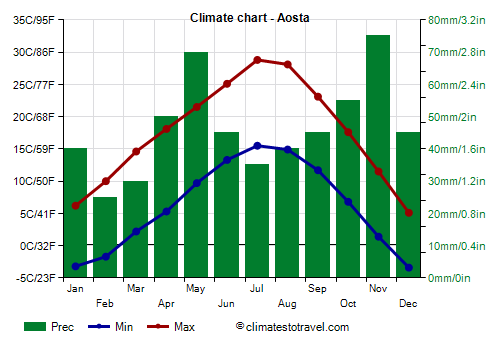
Aosta, the capital, is located in the center of the region, at an altitude of 580 metres (1,900 ft). The average temperature ranges from 1.5 °C (34.5 °F) in January to 22 °C (71.5 °F) in July. Winter is a fairly dry season, however, heavy snowfalls can sometimes occur. In summer it can get very hot, and the temperature can exceed 35 °C (95 °F).
Aosta - Average temperatures (1991-2020) |
| Month | Min | Max | Mean |
|---|
| January | -3.2 | 6.2 | 1.5 |
|---|
| February | -1.7 | 10 | 4.2 |
|---|
| March | 2.2 | 14.6 | 8.4 |
|---|
| April | 5.3 | 18.1 | 11.7 |
|---|
| May | 9.7 | 21.5 | 15.6 |
|---|
| June | 13.3 | 25.1 | 19.2 |
|---|
| July | 15.5 | 28.8 | 22.2 |
|---|
| August | 14.9 | 28.1 | 21.5 |
|---|
| September | 11.7 | 23.1 | 17.4 |
|---|
| October | 6.8 | 17.6 | 12.2 |
|---|
| November | 1.4 | 11.5 | 6.4 |
|---|
| December | -3.4 | 5.1 | 0.8 |
|---|
| Year | 6.1 | 17.5 | 11.75 |
|---|
Precipitation amounts to 550 mm (21.5 in) per year.
 Saint-Vincent
 is located in the eastern part of the main valley, practically at the same altitude, 575 metres (1,885 ft).
Let us now turn to the towns located in the nearby valleys, between 1,000 and 1,500 meters (3,300 - 4,900 feet, see Cogne, Courmayeur, Gressoney-Saint-Jean, La Thuile, Pâquier). At this altitude, the temperature can drop to -15/-20 °C (-4/5 °F) during cold spells, while in summer it can reach 30/32 °C (86/90 °F) on the hottest days.
In
Etroubles, located at an altitude of 1,340 metres (4,395 ft), the average temperature ranges from -0.5 °C (31 °F) in January to 16.5 °C (61.5 °F) in July.
Etroubles - Average temperatures (1994-2013) |
| Month | Min | Max | Mean |
|---|
| January | -3.5 | 2.5 | -0.5 |
|---|
| February | -3.2 | 3.9 | 0.3 |
|---|
| March | -0.4 | 7.6 | 3.6 |
|---|
| April | 2.3 | 10.5 | 6.4 |
|---|
| May | 6.3 | 15.2 | 10.7 |
|---|
| June | 9.6 | 19.4 | 14.5 |
|---|
| July | 11.5 | 21.7 | 16.6 |
|---|
| August | 11.3 | 21.1 | 16.2 |
|---|
| September | 8 | 16.7 | 12.3 |
|---|
| October | 4.6 | 11.8 | 8.2 |
|---|
| November | 0.3 | 6.1 | 3.2 |
|---|
| December | -2.8 | 2.7 | -0.1 |
|---|
| Year | 3.7 | 11.6 | 7.65 |
|---|
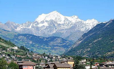
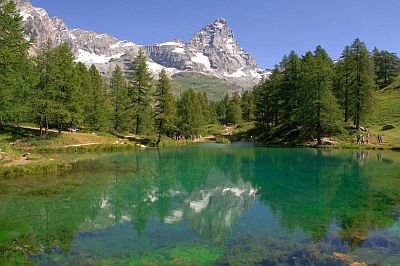
Valle d'Aosta is home to the four highest mountain massifs in Italy. In the north-west, on the border with France, is
Mont Blanc, which with its 4,810 meters (15,781 ft) is the highest mountain in Europe (according to some geographers it is Elbrus, located in the Caucasus). To the north, on the border with Switzerland, we find the
Matterhorn (Cervino), 4,478 metres (14,692 ft) and
Monte Rosa, 4,634 metres (15,203 ft). To the south we find the
Gran Paradiso, 4,061 metres (13,323 ft), protected in a national park.

At higher elevations, temperatures are low even in summer.
At the
Pian Rosà weather station, located at 3,488 meters (11,444 ft) on the Little Matterhorn glacier, on the border with Switzerland, the average temperature ranges from -12 °C (10.5 °F) in February to 2.5 °C (36.5 °F) in July and August. In winter, during cold snaps, the temperature can drop to -30 °C (-22 °F) or below. In March 1971 it dropped to -34.6 °C (-30.3 °F). In summer, during heat waves, which are becoming more frequent and contribute to melting glaciers, the temperature can reach or exceed 10 °C (50 °F). In August 1998 it reached 14 °C (57 °F).
Plateau Rosa - Average temperatures (1991-2020) |
| Month | Min | Max | Mean |
|---|
| January | -13.9 | -8.7 | -11.3 |
|---|
| February | -14.9 | -9.4 | -12.1 |
|---|
| March | -13.1 | -7.6 | -10.3 |
|---|
| April | -10 | -4.5 | -7.3 |
|---|
| May | -6.4 | -0.9 | -3.6 |
|---|
| June | -2.9 | 2.7 | -0.1 |
|---|
| July | -0.3 | 5.6 | 2.6 |
|---|
| August | -0.2 | 5.1 | 2.5 |
|---|
| September | -2.9 | 2 | -0.5 |
|---|
| October | -5.4 | -0.8 | -3.1 |
|---|
| November | -10.6 | -5.7 | -8.2 |
|---|
| December | -13.6 | -8.4 | -11 |
|---|
| Year | -7.8 | -2.5 | -5.15 |
|---|
At the
Capanna Regina Margherita, located in Piedmont, on the border with Switzerland and a short distance from the Aosta Valley, at 4,560 meters (14,961 ft) on Monte Rosa, the average temperature ranges from -19.5 °C (-3 °F) in February to -4 °C (25 °F) in July and August, when the maximum reaches around 0 °C (32 °F). However, when the African anticyclone arrives, the temperature can go above freezing. In February 2012, the temperature dropped to -37 °C (-34.5 °F), while at the end of June 2019 it reached 10 °C (50 °F).
Capanna Margherita - Average temperatures (2002-2020) |
| Month | Min | Max | Mean |
|---|
| January | -21.9 | -15.6 | -18.8 |
|---|
| February | -22.8 | -16.2 | -19.5 |
|---|
| March | -20.8 | -13.9 | -17.4 |
|---|
| April | -17.5 | -10 | -13.8 |
|---|
| May | -14.2 | -6.3 | -10.2 |
|---|
| June | -9.4 | -2.2 | -5.8 |
|---|
| July | -7.7 | -0.3 | -4 |
|---|
| August | -7.7 | -0.5 | -4.1 |
|---|
| September | -10 | -3.3 | -6.6 |
|---|
| October | -12.9 | -6.9 | -9.9 |
|---|
| November | -17.4 | -11.8 | -14.6 |
|---|
| December | -21.2 | -15.2 | -18.2 |
|---|
| Year | -15.2 | -8.5 | -11.85 |
|---|
When to go
You can go to Valle d'Aosta both in winter, perhaps for skiing, and in summer, perhaps for trekking in the mountains and to escape the heat of the plains.
See also the
temperatures by month.