Select units of measurement for the temperature and rainfall tables (metric or imperial).
Average weather, temperature, rainfall, sunshine hours
Summit Camp has a
polar (ice cap) climate, with temperatures below freezing all year round.
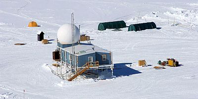
Summit Camp, or Summit Station, is a research station founded in 1989 and located in the center of Greenland, at the highest point of the ice sheet, at 3,216 meters (10,551 feet) above sea level and 72 degrees north latitude.

The average
temperature ranges from about -39 °C (-38 °F) from December to February to -12 °C (10.4 °F) in July.
On the
coldest days of the year, which can occur from December to March, the temperature drops to around -58/-60 °C (-72/-76 °F). The coldest record is -64.9 °C (-84.8 °F).
However, on 22 December 1991, in the same area, a temporary American station called Klinck, at 3,105 meters (10,187 ft) above sea level, measured a temperature of -69.6 °C (-93.3 °F), close to the lowest values recorded in Siberia (where, however, they were recorded in plain or hill locations).
In summer, from June to August, the temperature can occasionally reach or slightly exceed freezing. The highest record is around 2 °C (35.5 °F).
Here are the average temperatures.
Summit Camp - Average temperatures (1991-2020) |
| Month | Min | Max | Mean |
|---|
| January | -43.9 | -34.3 | -39.1 |
|---|
| February | -44.2 | -34.2 | -39.2 |
|---|
| March | -44.4 | -32.5 | -38.4 |
|---|
| April | -38.3 | -24.9 | -31.6 |
|---|
| May | -29.3 | -17.3 | -23.3 |
|---|
| June | -19.6 | -9.9 | -14.8 |
|---|
| July | -17 | -8 | -12.5 |
|---|
| August | -21.5 | -11.2 | -16.4 |
|---|
| September | -29.4 | -18.9 | -24.2 |
|---|
| October | -36.8 | -26.8 | -31.8 |
|---|
| November | -41.9 | -31.7 | -36.8 |
|---|
| December | -43.8 | -34.3 | -39 |
|---|
| Year | -34.1 | -23.6 | -28.8 |
|---|
The altitude is so high because a thick
layer of ice of about 3,000 meters (9,800 ft) has formed over the millennia.
The accumulation of ice from one year to the next is equivalent to about 24 cm (9.4 in) per year. Ice is snow that has settled on the ground, which is then compressed by gravity.
Due to the cold and the distance from the sea,
precipitation is very low, and is estimated at about 90 mm (3.5 in) per year, with a maximum in summer. As is also the case in Antarctica, the amount of snow that actually falls can only be estimated, because it is often light snow that is carried away by the wind.
Precipitation almost always occurs in the form of snow. In August 2021, the automatic weather station's sensors detected rain instead of snow for the first time.
As for the
length of the days, since we are north of the Polar Circle, there is a period, called
polar night, in which the sun does not rise, and which goes from November 14 to January 27.
Instead, the period of the
midnight sun, during which the sun never sets, goes from May 7 to August 6. Before and after this period, the
white nights, in which it is not completely dark all night, last more than six months, from April 4 to September 8.