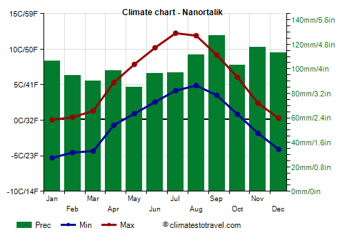
Select units of measurement for the temperature and rainfall tables (metric or imperial).
Average weather, temperature, rainfall, sunshine hours

In Nanortalik, there is a
polar tundra climate, although with maritime influences, with cold winters, during which the temperature is a few degrees below zero, and quite mild summers.
Nanortalik (Bjørnsted in Danish) is a town of 1,100 inhabitants, located in the extreme south of Greenland, in the municipality of Kujalleq, on a small island at the mouth of Tasermiut fjord, a few kilometers from the Labrador sea coast, and at 60 degrees north latitude.
About 40 km (25 mi) to the northeast is the
Qinngua valley, which is home to the only natural forest in Greenland. Evidently, the surrounding mountains shelter the valley, which must therefore have a subarctic climate, with an average in the warmest months above 10 °C (50 °F), and with fairly frequent föhn winds.
North of this valley are
steep mountains, such as Ketil and Ulamertorsuaq, which reach almost 2,000 meters (6,500 feet) and are a destination for climbers and mountaineers from all over the world.
The name Nanortalik means "place with bears", because sometimes, rarely to be honest,
polar bears can arrive, brought by the ice coming from the east coast of Greenland, where a cold current flows. Icebergs cover the sea in the area from January to June.
In fact, about 80 km (50 mi) to the southeast is
Cape Farvel, the southernmost point of Greenland, from where the ice arrives after having traveled along the east coast down to this latitude.
 Precipitation
 is quite abundant, since it amounts to 1,200 millimeters (47 inches) per year, with a maximum in autumn and winter.
The
winter is cold, but it is significantly less cold and long than in central-northern Greenland. The average temperature in January is around -2.5 °C (27.5 °F).
During the day the average temperature is around freezing from December to March, however, it can sometimes exceed this value, and it can rain even in this season. On the other hand, the humidity is high and the wind blows often, increasing the feeling of cold. Sometimes snowfall can be heavy.
During
cold waves, the temperature drops below -10 °C (14 °F), and sometimes to -15 °C (5 °F). In the past it may have reached lower values (we do not have data regarding records).
Summer, from June to August, is quite mild. The average in August is around 8.5 °C (47.5 °F).
Rainfall is quite frequent, and it practically never snows, except occasionally in the first half of June.
In this season,
fog forms quite often.
Sometimes there can be short
very mild periods, from one to three days, during which the temperature can reach or exceed 20 °C (68 °F).
In Nanortalik the
sea is always very cold, and drops to around 0 °C (32 °F) at the end of winter. As we have said, this area receives icebergs from the east coast of Greenland.
As for the
length of the days, since we are south of the Arctic Circle, the sun rises even on the shortest days of the year, and sets on the longest.
However, the
white nights, in which it is not completely dark all night, occur from May 11 to August 1.
Nanortalik - Climate data
In Nanortalik, the
average temperature of the coldest month (January) is of
-2.6 °C, that of the warmest month (August) is of
8.4 °C. Here are the average temperatures.
Nanortalik - Average temperatures (2005-2017) |
| Month | Min | Max | Mean |
|---|
| January | -5.3 | 0.1 | -2.6 |
|---|
| February | -4.5 | 0.4 | -2.1 |
|---|
| March | -4.3 | 1.3 | -1.5 |
|---|
| April | -0.7 | 5.3 | 2.3 |
|---|
| May | 0.9 | 7.9 | 4.4 |
|---|
| June | 2.6 | 10.2 | 6.4 |
|---|
| July | 4.2 | 12.3 | 8.2 |
|---|
| August | 4.9 | 11.9 | 8.4 |
|---|
| September | 3.5 | 9.2 | 6.4 |
|---|
| October | 0.9 | 6.1 | 3.5 |
|---|
| November | -1.8 | 2.4 | 0.3 |
|---|
| December | -4.1 | 0.3 | -1.9 |
|---|
| Year | -0.3 | 5.6 | 2.65 |
|---|
amounts to
1240 millimeters per year: it is therefore quite abundant. It ranges from
85.3 millimeters in the driest month (May) to
127.4 millimeters in the wettest one (September). Here is the average precipitation.
Nanortalik - Average precipitation| Month | Days |
|---|
| January | 106 | 13 |
|---|
| February | 95 | 12 |
|---|
| March | 90 | 13 |
|---|
| April | 99 | 12 |
|---|
| May | 85 | 11 |
|---|
| June | 96 | 11 |
|---|
| July | 97 | 14 |
|---|
| August | 112 | 11 |
|---|
| September | 127 | 13 |
|---|
| October | 103 | 12 |
|---|
| November | 118 | 12 |
|---|
| December | 113 | 13 |
|---|
| Year | 1240 | 146 |
|---|
The
sea temperature ranges from
0 °C in March, April to
4.5 °C in August. Here are the average sea temperatures.
Nanortalik - Sea temperature| Month |
|---|
| January | 1 |
|---|
| February | 0.5 |
|---|
| March | 0 |
|---|
| April | 0 |
|---|
| May | 1 |
|---|
| June | 2.5 |
|---|
| July | 4 |
|---|
| August | 4.5 |
|---|
| September | 4 |
|---|
| October | 3 |
|---|
| November | 2"> |
|---|
| December | 1.5 |
|---|
| Year | 2 |
|---|